
Public Lands · Mining Claims · Real Adventures
See BLM Mining Claims, Public Land & Mineral Data on One Simple Map
Staked Maps brings mining claim records, public land information, historical claims and mineral data together in one easy map built for U.S. prospectors. Research an area at home, save the maps you need, and head into the field better informed.
No credit card required.
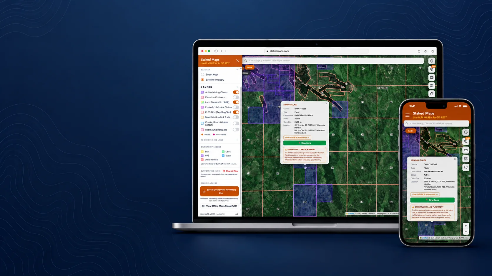
Current mining claim data across 13 Western states
Includes BLM federal claims plus Alaska state-recorded claims where applicable. “Current” means not marked closed: of 593,210 current BLM federal records, BLM’s case disposition labels 425,366 Active; the rest are Filed, Under Review or another non-closed status.
633,509
Current / Not-Closed Claim Records
3,754,660
Historical Claims
172,278
Documented Mineral Occurrences
30-Day Claim Activity Tracking
Tracking began September 10, 2026. The first complete 30-day activity report will be available after October 10, 2026.
BLM data last synchronized
What Is Staked Maps?
Staked Maps is a U.S. prospecting and mining claim research application that combines federal BLM mining claim records, Alaska state claim records where applicable, surface management information, historical claims and USGS mineral occurrence data in one interactive map. It's built for recreational and serious gold prospectors, people researching existing claims before staking their own, and rockhounds looking for documented collecting sites. Instead of working directly with BLM's raw case-recordation system or a separate state GIS portal for each layer, you can find your area, review recorded claim activity and land status, and open individual claim details from a phone or desktop — at home or in the field.
How It Works
From Question to Map in Minutes
Find Your Area
Pick your state, search by county, or use your device's location — free accounts get core map access for one state.
See What's Recorded
Recorded mining claims, surface management overlays, and relevant research layers appear on the same map — no switching between government sites.
Prepare for the Field
Open a claim's details, download the map for offline use, and take your research with you before you head out.
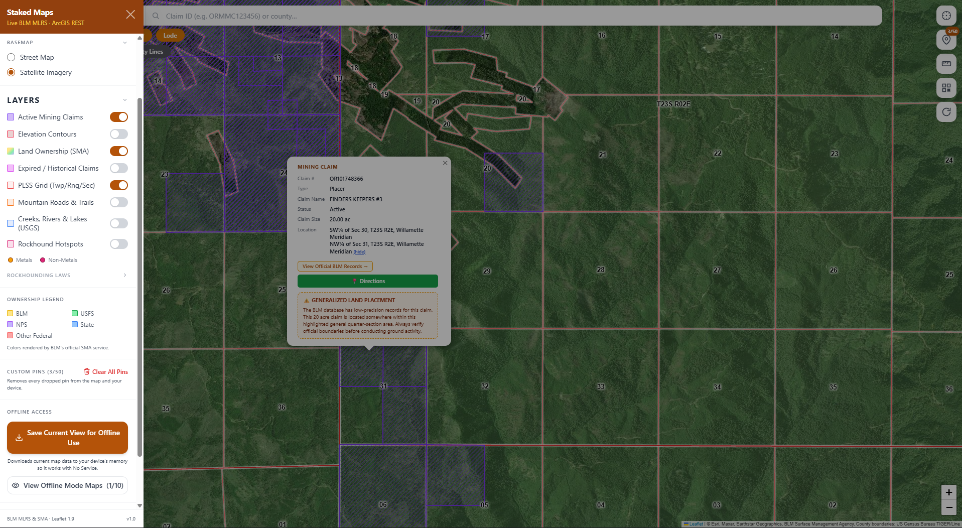
Answer the Questions Prospectors Actually Have
Is this area heavily claimed?
See current and historical mining claim activity for any area you're researching, not just a single pin.
What does the recorded claim cover?
Open a claim to see its interpreted map polygon alongside the recorded claim information behind it.
Who manages the land?
See which agency manages the surface (BLM, USFS, NPS and other mapped public-land categories) alongside claim data. Surface management doesn't by itself establish mineral ownership or whether prospecting is permitted.
Has mining occurred here before?
Historical claim records and USGS-sourced mineral occurrences show where mining activity and documented mineral occurrences have been recorded before.
What should I research before going?
Every claim links back to the source record, and paid plans let you download the map for offline field use.
How Staked Maps Turns BLM Records Into Useful Claim Maps
BLM's Mineral & Land Records System (MLRS) — which replaced the legacy LR2000 mining claim system in 2021 — is the authoritative federal record and does include its own mapping tools. But researching a prospecting area usually means working across claim records, PLSS information, land management data, historical records and other datasets spread across separate systems. Staked Maps brings those sources into one prospecting-focused map and interprets each claim's recorded legal description — something like "NE¼ NW¼ Sec. 12, T5N R3W" — into a practical research polygon, always linking back to the official MLRS record.
The Public Land Survey System (PLSS) the BLM still uses today divides the West into a grid of townships and ranges, each split into one-mile-square sections (640 acres). A legal description narrows that down with "aliquot parts" — NE, NW, SE, SW — where each added code quarters the area again: a quarter section is nominally 160 acres and a quarter-quarter (e.g. "NE NW") is nominally 40 acres. These successive divisions identify an increasingly specific portion of the section, but they're a legal subdivision, not necessarily the physical footprint of the claim itself. A lode claim is typically limited to roughly 20.66 acres (1,500 by 600 feet) and a placer claim to 20 acres per locator. Our parsing engine walks that code out from the real origin point of your specific meridian and computes the resulting rectangle mathematically as the recorded area associated with the claim. It's a close, genuinely useful approximation, not a survey-grade boundary, and BLM's own source description isn't always precise either. For boundary-sensitive decisions, review the official BLM record, recorded county location documents and maps where applicable, and on-the-ground claim monuments. If an exact legal boundary must be established, professional surveying or legal guidance may be necessary.
Legal Disclaimer
Staked Maps is a research and navigation tool. Claim polygons are derived from recorded legal land descriptions and may not match surveyed claim corners. Always verify current land status, official records, applicable regulations and on-the-ground claim markers before prospecting or staking a claim.
Information hosted on Staked Maps is compiled from publicly available data streams provided by the Bureau of Land Management (BLM) and relevant state geographic clearinghouses. Staked Maps accepts no liability for the content of this geospatial data, or for the consequences of any real-world exploration, land entry, or staking actions taken on the basis of the information provided via this application interface.
These mapping layers and related graphics are visual convenience aids only; they are not legal documents and must never be used as such. The data may not be used to legally determine title, mineral ownership, valid description boundaries, jurisdictional authorities, or land restrictions in place on public or private land. Federal records are dynamic and change constantly — the end user is exclusively responsible for validating current land classifications with local BLM field offices and managing compliance accordingly.
See Where the Information Comes From
Staked Maps isn't crowd-sourced guesswork. Every layer traces back to an authoritative government dataset, not a generic scrape.
Mineral & Land Records System (MLRS)
BLM data last synchronized
Source for current and historical federal mining claim records. MLRS replaced the legacy LR2000 mining claim system in 2021.
U.S. Geological Survey
Mineral Resources Data System (MRDS)
Nationwide snapshot, last ingested August 2026
Source for Rockhound Hotspots, cross-referenced by material — documented occurrences, not a guarantee of legal or accessible collecting.
Bureau of Land Management
Surface Management Agency (SMA)
Nationwide snapshot, built August 2026
Displays federally mapped surface-management categories, including BLM, USFS, NPS and other agencies. Surface management doesn't by itself establish mineral ownership or whether prospecting is permitted.
For legal filings, always confirm current status directly with your BLM state office of record; Staked Maps is a research and navigation tool, not a substitute for the official record.
Before You Prospect: Check More Than One Layer
A claim polygon alone doesn't answer every question. Staked Maps helps you organize the research — it isn't a substitute for it.
- 1.Check recorded mining claim activity for the area, both active and historical.
- 2.Review surface management information to see which agency manages the surface. Surface management doesn't by itself establish mineral ownership or whether prospecting is permitted.
- 3.Open the claim record and history for full legal description and status.
- 4.Review applicable local rules or restrictions with your BLM state office.
- 5.Verify current official records and on-the-ground claim markings when it matters.
No single map layer can determine every legal access or prospecting question — Staked Maps helps you research recorded claims, land information and other relevant data, but you should verify current regulations, official records and field conditions yourself.
What the Current Mining-Claim Data Shows
Every BLM claim parses down to a real legal type: lode, placer, or mill/tunnel site. Every Rockhound Hotspot traces back to a real USGS record.
499,209
Lode Claims
77,978
Placer Claims
163,234
Metallic Rockhound Sites
9,044
Non-Metallic Rockhound Sites
States with the most current (not-closed) claim records right now: Nevada (278,969), Arizona (65,619), Wyoming (49,395), Utah (43,423), Idaho (41,368).
The current/not-closed total (above) also includes 16,023 mill/tunnel-site claims and 40,299 Alaska state-recorded claims, tracked separately under Alaska's own system rather than BLM's federal lode/placer/mill-tunnel classification. Together with Lode and Placer, that fully accounts for the current/not-closed total.
BLM data last synchronized
30-Day Claim Activity Tracking
Tracking began September 10, 2026. The first complete 30-day activity report will be available after October 10, 2026.
What You Can Do With Staked Maps
Understand claim activity
Current and historical claims, lode vs. placer, and claim status at a glance.
Understand the land
Surface management overlays, street/satellite basemaps, and PLSS grid layers.
Research mining history
Expired and historical claims plus USGS-sourced Rockhound Hotspots by material.
Take your research into the field
Offline map downloads, compass, custom pins, and distance measurement.
Why Not Just Use the Raw Government Records?
| Staked Maps | BLM MLRS | |
|---|---|---|
| Official federal claim record | Links to it | Yes, authoritative source |
| Prospecting-focused interface | Yes | General federal land/mineral system |
| Claim + SMA + historical + mineral-occurrence research together | Yes | Requires broader research workflow |
| Interpreted research polygons | Yes | Official BLM spatial representation |
| Offline field map | Yes, paid plans | Not its primary purpose |
| Built specifically for prospectors | Yes | No |
Mining Claim Maps by State
Alaska (AK), Arizona (AZ), California (CA), Colorado (CO), Idaho (ID), Montana (MT), Nevada (NV), New Mexico (NM), Oregon (OR), South Dakota (SD), Utah (UT), Washington (WA), Wyoming (WY).
Rockhound Hotspots and the offline basemap layers (elevation contours, trails, water) extend beyond these 13 to all 50 states nationwide.
Built for the Creek Bed, Not the Desk
Staked Maps was born out of backcountry frustration with the government's clunky public databases on a mobile browser, standing in remote canyons with no connection. Standard mapping apps cater broadly to hikers or hunters, leaving miners and rockhounds with flat, outdated mine points.
Staked Maps is operated by Phi McRee Designs LLC. Read the full story on the About page →
Product data and research methodology maintained by Staked Maps.
Getting Started
Creating Your Free Account
Create a Free Account
Sign up in seconds — just an email and password, no card required.
Verify Your Email
Click the confirmation link we send you — you'll land right back here automatically.
Choose Your Home State
Pick the state you prospect in most — free accounts get core map access for one state.
Plans
Choose Your Plan
Basic
Free
Try Staked Maps in one state.
$0/mo
- ✓Interactive mining claims map — pick your state (or use your location)
- ✓Surface management overlays & current mining claims
- ✓Claim type, name, status & size in claim popups
Paid plans unlock full claim details, historical claims, research layers and offline tools.
Local Miner
Single State
For prospectors who mostly work one state.
$29.99/yr
Everything in Free, plus:
- ✓1 state of your choice, full premium data
- ✓Full legal location (aliquot description) for every claim
- ✓Offline map downloads
Adventure Miner
Tri-State
For prospectors who cross nearby state lines.
$49.99/yr
Everything in Free, plus:
- ✓3 states of your choice, full premium data
- ✓Full legal location (aliquot description) for every claim
- ✓Offline map downloads
Pro Prospector
All-West
For serious Western prospectors.
$99.99/yr
Everything in Free, plus:
- ✓All 13 Western states, full premium data
- ✓Full legal location (aliquot description) for every claim
- ✓Offline map downloads
Just here to rockhound?
Rockhound Enthusiast
National Rockhound Pass
For nationwide rockhounding research.
$29.99/yr
Gem & crystal hunters, Midwest/East users — everything in Free, plus:
- ✓All 50 states, nationwide coverage
- ✓Nationwide Rockhound Hotspots + Metals/Non-Metals filters
- ✕Claim serial number, owner intel, BLM Records & historical claims
Single State, Tri-State and All-West all unlock the exact same features — nothing is pay-gated between them, they differ only in how many states you get.
Paid plans renew automatically at the monthly or annual rate you choose until you cancel. Cancel anytime and keep access through the end of your paid period. See our Terms of Use.
Frequently Asked Questions
What is Staked Maps?
A U.S. prospecting and mining claim research application that combines BLM mining claim records, land information, historical claims and mineral data in one interactive map.
Where does Staked Maps get its mining claim data?
Directly from the Bureau of Land Management's official MLRS (Mineral & Land Records System) case-recordation records, synced into our database on a regular schedule — not scraped or crowd-sourced.
How current is the mining claim data?
Current claim data syncs on a nightly schedule; historical/closed claim counts are revalidated monthly. Each data-source section on this page shows the actual last-synced date.
Are Staked Maps claim boundaries exact?
No. Claim polygons are computed from BLM's recorded legal land descriptions (PLSS aliquot parts), not surveyed GPS boundaries. They are useful research approximations and should not be treated as professional surveys. For boundary-sensitive decisions, review the official BLM record, recorded county location documents and maps where applicable, and on-the-ground claim monuments; if an exact legal boundary must be established, professional surveying or legal guidance may be necessary.
Does Staked Maps show public land?
Yes. Surface management overlays (BLM, USFS, NPS and other mapped public-land categories) are included alongside claim data, so you can see which agency manages the ground. Surface management doesn't by itself establish mineral ownership or whether prospecting is permitted.
Can Staked Maps tell me whether an area is legally open for prospecting?
No single map layer can determine every legal access or prospecting question. Staked Maps helps you research recorded claims, land information and other relevant data, but you should verify current regulations, official records and field conditions before prospecting or staking a claim.
Is Staked Maps free to use?
Yes. The free tier gives you the interactive claims map, surface management overlays, and basemap layers for one state you choose — no subscription required. Paid plans add more states plus premium data like full legal descriptions, historical claims, offline downloads, and Rockhound Hotspots.
Does Staked Maps track or share my location?
No. You can pick your state manually, or optionally use your device's location to do it for you — either way, your location is only ever used in your browser to find your state and center the map. It's never sent to our servers or shared with anyone.
What's the difference between current, Active and historical claims?
Current (not-closed) claims are records not marked closed in BLM's MLRS data. They include records with BLM's Active case disposition plus Filed, Under Review and other pending statuses, so “current” and “Active” are not the same count. Historical claims are records shown as closed, expired or otherwise no longer in force, still useful for understanding an area's mining history and past activity. Record status shouldn't be interpreted as a legal determination of claim validity or exact field boundaries.
Can I use Staked Maps offline?
Yes — paid plans support offline map downloads, so claim boundaries, surface management data, topography, and trails stay available with zero cell service.
Does Staked Maps work on phones?
Yes. Staked Maps runs in any mobile browser with no app install required, and paid plans support offline downloads for use without cell service.
How is Staked Maps different from BLM MLRS?
BLM MLRS is the authoritative federal record and includes its own mapping tools. But researching a prospecting area often means working across claim records, PLSS information, land management data, historical records and other datasets spread across separate systems. Staked Maps brings those sources into one prospecting-focused map, interprets recorded claim locations into practical research polygons, and layers in surface management data, historical claims and Rockhound Hotspots — always linking back to the official MLRS record for legal purposes.
Which states does Staked Maps cover?
Live BLM mining claims and surface management data are tracked across the 13 core public domain mining states: Alaska, Arizona, California, Colorado, Idaho, Montana, Nevada, New Mexico, Oregon, South Dakota, Utah, Washington, and Wyoming. Rockhound Hotspots and the offline basemap layers now cover all 50 states nationwide.
What are Rockhound Hotspots?
A premium map layer built from documented USGS mineral occurrences, labeled by material where available (e.g. turquoise, opal, jasper). It's a research lead for rockhounds, not a verified collecting-access directory.
Is my payment information secure?
Yes — all payments are processed by Stripe. Staked Maps never sees or stores your card details directly.
Check the Ground Before You Go
See mining claims, land information and historical mining data in one straightforward prospecting map.
No credit card required.