Colorado Mining Claims Map: Current BLM Claims, Counties & Land Status
Staked Maps tracks Colorado's current, not-closed federal mining claim and site records from BLM-derived data and combines them with land-management, PLSS, historical-claim and mineral-occurrence research layers. As of the data date above, Colorado has 14,935 current/not-closed records; BLM's own case disposition currently labels 13,179 of those Active, with the remainder Filed, Under Review, Submitted, On Appeal or Draft. Current is not the same thing as BLM Active — the full breakdown is below.
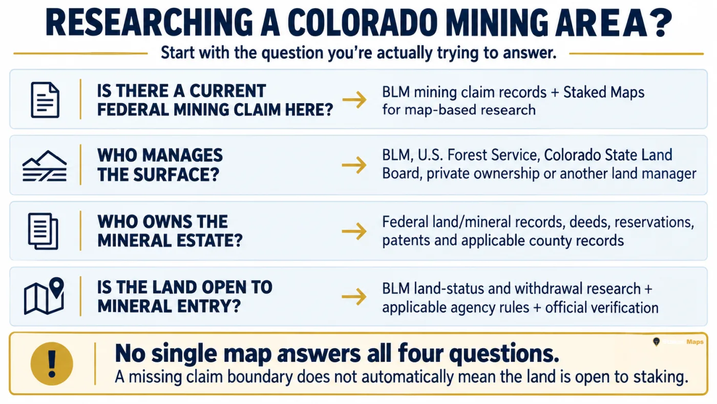
A gap between mapped claims does not automatically mean the ground is open for prospecting or claim location. Mineral ownership, surface management, withdrawals, existing rights and other land-status rules still need to be verified.
Free account · No credit card required · Opens directly to the Colorado map
Colorado Mining Claims at a Glance
14,935
Current / Not-Closed Federal Claim & Site Records
13,179
BLM Disposition: Active
288,571
Historical Claim Records
13,624
Documented Mineral Occurrences
Mining claim data synchronized: . Records sync from BLM on a regular schedule, not live with every visit.
What Does a Current Colorado Mining Claim Record Mean?
Staked Maps uses “current” for federal mining claim and site records that are not marked closed in its reconciliation process. That is not the same thing as the BLM case disposition “Active.” Current Colorado records can carry any of several BLM dispositions:
BLM Status
Records
Share of Current Records
Active
13,179
88.2%
Filed
1,658
11.1%
Under Review
75
0.5%
Submitted
20
0.1%
On Appeal
2
<0.1%
Draft
1
<0.1%
Current does not mean the same thing as BLM Active. Filed, Under Review, Submitted, On Appeal and Draft records all have a pending or distinct BLM case status and shouldn't be treated as identical to a fully Active claim. Staked Maps is not independently judging legal claim validity — verify a specific claim's exact status through BLM MLRS before relying on it.
What Types of Mining Claims and Sites Are Current in Colorado?
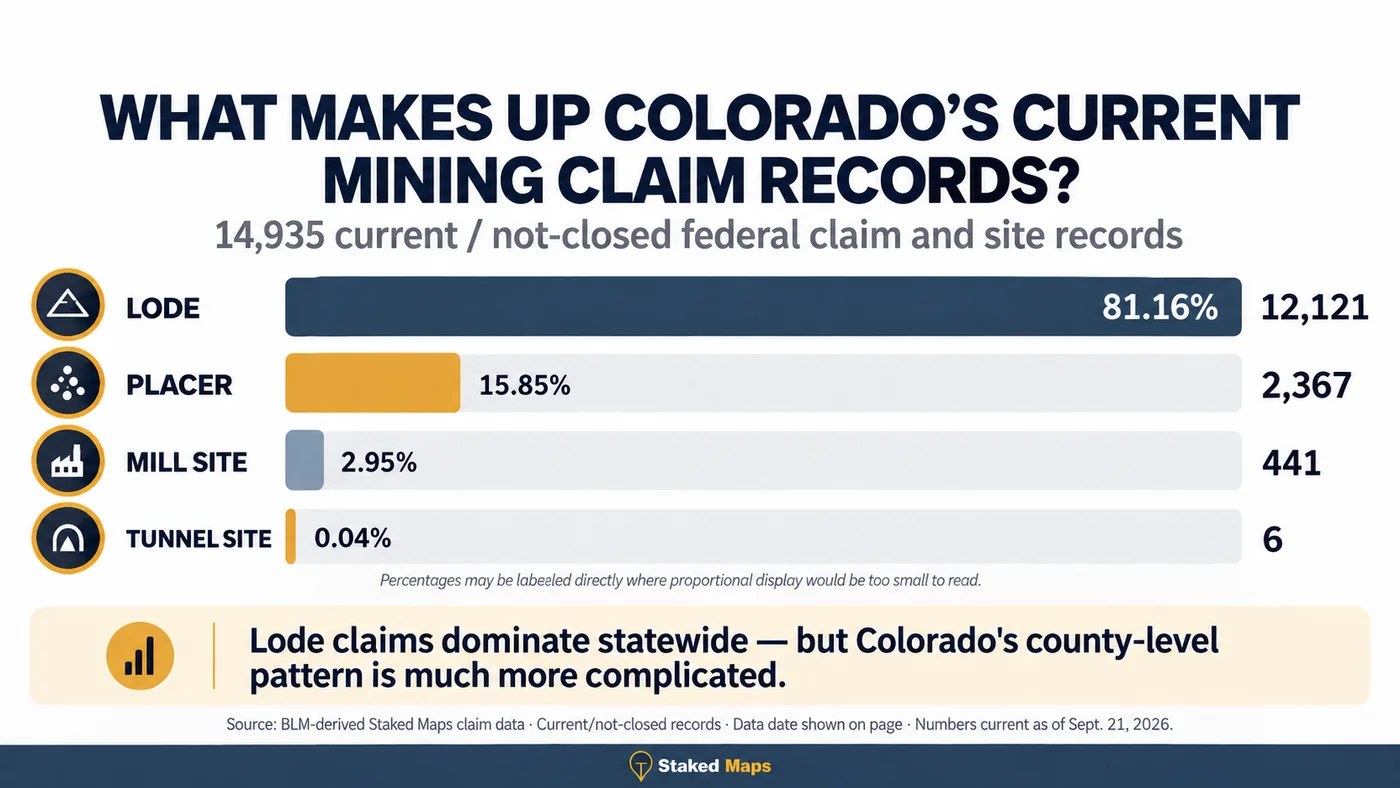
Colorado's current federal record population is heavily lode-dominant, but it also includes placer claims, Mill Sites and Tunnel Sites.
12,121
Lode Claims
2,367
Placer Claims
441
Mill Site Claims
6
Tunnel Site Claims
Lode and placer records describe different forms of mineral location; mill sites and tunnel sites are separate location types under the Mining Law, not a third mineral-claim category. The mix is useful for understanding the character of recorded activity, but it doesn't determine whether surrounding land is open to new claim location.
Colorado Claims by Type, Visualized
Claim Type
Current Claims
Lode Claims
12,121 (81.2%)
Placer Claims
2,367 (15.8%)
Mill Site Claims
441 (3.0%)
Tunnel Site Claims
6 (<0.1%)
Where Are Current Colorado Mining Claims Concentrated?
The table shows Colorado's ten counties with the most current records. Separately, 322 current records in this snapshot could not be assigned to a Colorado county by the spatial county-boundary join.
Montrose County currently contains the largest share of Colorado's mapped current claim/site records, followed by Gunnison County and Moffat County. Together, Montrose County, Gunnison County and Moffat County account for 35% of the statewide total. Lode records make up 81.2% of current claims statewide and placer records 15.8%, with the remaining 3.0% recorded as tunnel or mill sites. Montrose County has the most lode records and Eagle County has the most placer records. Claim density alone does not establish mineral potential or whether nearby ground is open to location, but it provides a useful starting point for researching where mining activity is concentrated.
The top four counties, Montrose County, Gunnison County, Moffat County and San Miguel County, account for 45.0% of Colorado's current/not-closed federal mining claim and site records.
Remaining Colorado Counties With Current Mining Claim Records
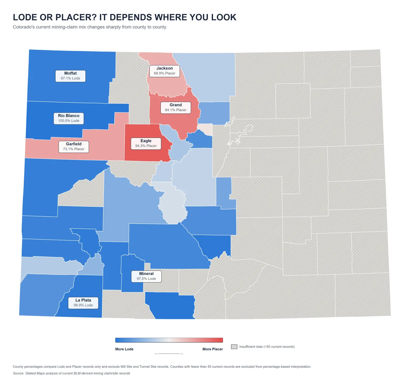
Colorado's Lode and Placer Claims Follow Different Geographic Patterns
Colorado is overwhelmingly lode-dominant statewide — 81.2% of current claim and site records are Lode versus 15.8% Placer — but that statewide figure hides large county-level differences.
Among counties with at least 50 current records, the most placer-oriented are Eagle County (94.3% placer), Grand County (84.1% placer), Garfield County (73.1% placer), Jackson County (68.9% placer) and Gilpin County (53.5% placer). At the other end, the most lode-oriented among current lode-and-placer records are Rio Blanco County (100.0% lode), Conejos County (100.0% lode), Custer County (99.1% lode), La Plata County (98.9% lode), Ouray County (98.5% lode), Mineral County (97.5% lode), Mesa County (97.2% lode) and Hinsdale County (97.2% lode).
For county percentage comparisons, Staked Maps used counties with at least 50 current records and compared Placer records against the combined Lode + Placer population. Mill Site and Tunnel Site records are excluded from that specific lode-versus-placer percentage calculation.
County claim-type comparison using Staked Maps current-record data.
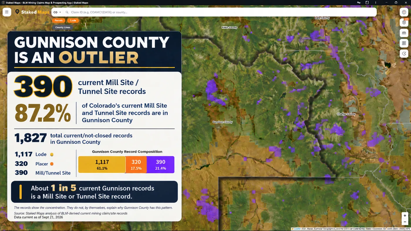
Why Gunnison County Looks Different in the Claim-Type Data
Gunnison County has 1,827 current/not-closed federal mining claim and site records: 1,117 Lode, 320 Placer, and 390 Mill Site or Tunnel Site records. That Mill/Tunnel share, about 21.3% of Gunnison's own current records, is unusual: Gunnison County alone accounts for 390 of Colorado's statewide 447 current Mill Site and Tunnel Site records, or about 87.2%.
The data shows the concentration. It does not, by itself, explain why Gunnison County has this unusually large share of Colorado's current Mill Site and Tunnel Site records.
Gunnison County claim-type composition in Staked Maps.
Colorado's Historic Mining Geography Still Matters for Research
Colorado's hard-rock mining history concentrates along the Colorado Mineral Belt, a roughly diagonal zone of historic metal-mining districts running from the San Juan Mountains in the southwest toward Boulder County on the Front Range, plus major historic mineralized districts such as Cripple Creek outside that belt. Colorado Geological Survey publishes maps of these historic mining districts.
Colorado Geological Survey's historic-mining-district boundaries are interpretive and estimated rather than legal boundaries. Staked Maps has not performed a spatial analysis of current claims against the Mineral Belt, the Leadville district, Cripple Creek, or any historic mining district — treat district geography as historical context for research, not as a statement about where current claims are located.
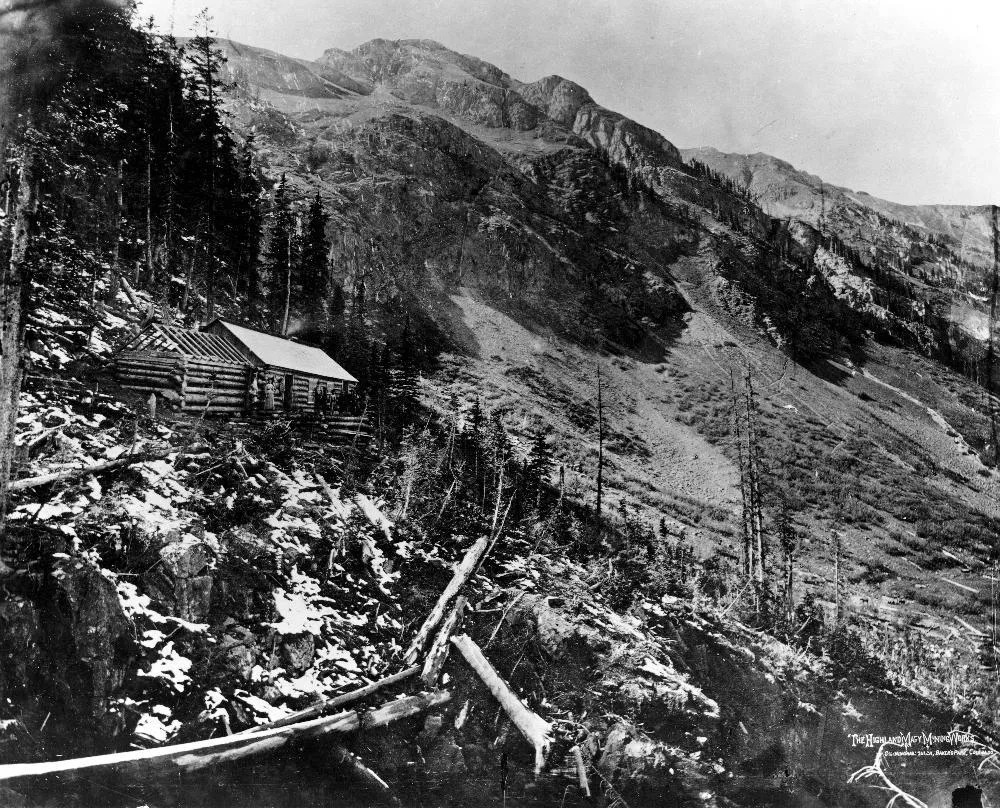
Historical mining photograph. U.S. Geological Survey, Public Domain. Jackson, W. H. — The Highland Mary Mining Works, Cunningham Gulch, Bakers Park, San Juan County, Colorado.
An Abandoned Mine Is Not the Same as a Closed Mining Claim
An abandoned mine is a physical mine feature or site. A historical or closed mining claim is a case/record status. Those are different things.
Colorado Geological Survey estimates 23,000 abandoned mine sites on public and private land statewide (CGS, Abandoned Mine Lands). An abandoned mine does not prove that the land is open to mineral entry, that there is no current claim, that the public has legal access, that prospecting is permitted, that mineral rights are federal, or that the site is safe to enter.
Abandoned mine workings can be dangerous and should not be entered.
If No Current Claim Appears, Is the Land Open to Staking?
No. The absence of a current mining claim record is only one part of the land-status research. You still need to determine mineral ownership, surface management, whether the land is open to mineral entry, withdrawals, special designations, wilderness restrictions where applicable, the private-surface/federal-mineral split estate, Colorado state trust land, and agency-specific restrictions.
A useful Colorado example: BLM manages 8.3 million acres of public land in Colorado and 27 million acres of federal mineral estate (BLM, What We Manage in Colorado). Surface ownership and mineral ownership are not the same thing and cannot be treated as identical.
Who Handles Mining Claims, Land Status and Mining Regulation in Colorado?
Question
Agency / Record Source
What It Handles
Federal mining claim records & mineral estate
Bureau of Land Management (BLM)
Federal mining claim records, federal mineral estate, and land-status/withdrawal research.
Mining/reclamation permits
Colorado Division of Reclamation, Mining and Safety (DRMS)
Regulates mining and reclamation permits within the state. Does not administer federal mining claims.
Geology & historic districts
Colorado Geological Survey (CGS)
Geology, mineral resources, historic mining districts, and abandoned-mine information.
State trust land
Colorado State Land Board
State trust surface and mineral estate, and applicable state mineral leasing.
National Forest surface management
U.S. Forest Service (USFS)
Surface-management requirements on National Forest System lands.
Deeds & title records
County Clerk & Recorder
Deeds, title-related records, and private property/mineral reservations where applicable.
Colorado State Trust Land Uses a Different System
Colorado State Land Board manages 2.8 million surface acres and 4.0 million acres of mineral estate (Colorado State Land Board, About). State trust land is not automatically open public recreation land, and federal BLM mining-claim procedures do not simply apply to Colorado state trust mineral estate.
What it is: The official federal Bureau of Land Management Colorado State Office portal governing public domain mineral entry, land records, and unpatented claim filings across Colorado.
Use case: Submitting new location notices, paying annual federal claim maintenance fees, filing Small Miner's Maintenance Fee Waivers (Form 3830-002), and getting filing assistance from the Denver Public Room.
What it is: The official state geological survey providing state geological maps, mineral resource reports, and historical mining district data.
Use case: Accessing state geological publications, researching historical mining district records, downloading digital geologic maps, and evaluating state mineral land classifications.
What it is: The primary state-level portal for the Bureau of Land Management in Colorado, overseeing 8.3 million acres of public domain surface land and over 27 million acres of subsurface mineral estate across the state.
Use case: Accessing district and field office contact directories, verifying regional fire restrictions and land closures, reviewing statewide land use planning projects, and obtaining general administrative information for public land entry across Colorado.
Source records sometimes use broad or overlapping commodity labels; counts above preserve the underlying record classifications.
Colorado Top Rockhounding Materials, Visualized
Material
Sites Recorded
Feldspar
76
Quartz
36
Gemstone
31
Mica
13
Fluorine-Fluorite
8
Abrasive, Garnet
7
Staked Maps filtering keeps point features, excludes DEV_STAT = Plant, and excludes selected bulk/industrial commodity groups; the dataset is a mix of prospects, occurrences, producers, past producers and other MRDS development statuses.
These records are research context, not a directory of verified public collecting sites. They do not establish public access, permission to collect, open mineral-entry status, mineral ownership, or the absence of mining claims.
How Staked Maps Builds the Colorado Mining Claims Map
Staked Maps processes publicly available Bureau of Land Management claim records and synchronizes them into a map optimized for field research. It isn't a substitute for the official record.
Current/not-closed records: Records in Staked Maps' current dataset that have not been marked closed through the reconciliation process. Synced from BLM's MLRS/NLSDB ArcGIS service through nightly incremental sync plus periodic full reconciliation.
BLM disposition: Retained separately as source data from BLM and may be Active, Filed, Under Review, Submitted, On Appeal or Draft. BLM case-type values are normalized into Lode, Placer, Mill Site and Tunnel Site.
Historical claims: Sourced from BLM's historical/closed claims layer. Staked Maps does not represent its local historical cache as a complete archival mirror of BLM's own records.
Sync schedule: Nightly incremental sync plus periodic full reconciliation against BLM MLRS/NLSDB.
Claim geometry: Claim boundaries are derived from each record's legal (aliquot) description under the Public Land Survey System; some claims use BLM's own coarser aliquot-level approximation rather than a fully surveyed footprint.
Counties: County assignment is a spatial match against U.S. Census TIGER/Line county boundaries, not a field BLM provides directly. 322 current Colorado records could not be resolved to a single county by that match as of the data date above.
Rockhound / mineral data: Sourced from USGS MRDS. Filtered to point features, excluding processing plants and selected bulk/industrial commodity groups.
Land / PLSS: Public Land Survey System and land-management research layers are sourced from BLM's own published GIS layers.
Limitations: Staked Maps is a research tool. It does not establish legal claim validity, mineral ownership, surface-access rights, or whether land is open to mineral entry — verify any specific parcel through BLM MLRS and the applicable land-management agency before relying on it.
A Practical Colorado Mining-Claim Research Workflow
Identify the area you want to research.
Review current claim/site records and claim types.
Compare historical claims and mineral-occurrence context where useful.
Determine surface manager, mineral ownership, withdrawals, and whether the land is open to mineral entry.
Verify the applicable official BLM, state, county, or land-management record before relying on the result.
Staked Maps is a research tool that helps bring map-based context together — not a legal determination, a title search, proof that land is open, or proof that land is unclaimed.
Research Colorado Mining Areas in Staked Maps
See current mining claim records alongside land-management, PLSS, historical-claim and mineral-occurrence layers in one map-based research workflow.
How Do You View Colorado BLM Mining Claims Offline?
Save any map area while you have cell service, then navigate active BLM mining claims, surface-management boundaries, and optional layers like elevation contours, roads, and creeks — with zero connectivity out in the field. Offline downloads are included on every paid plan. See plans below →
What Premium Adds to Your Colorado Map
Historical Claims. See where mining activity existed before today's current records.
Full Claim Details. Serial number, legal location and a direct BLM record link.
Research Layers. PLSS, roads/trails, waterways and Colorado mineral occurrences.
Offline Maps. Save your Colorado research before losing cell service.
Field Tools. Directions, custom pins, measurements and claim-drafting tools.
Single State unlocks all premium features for Colorado for $29.99/year.
Plans
Choose Your Plan
Basic
Free
Try Staked Maps in one state.
$0/mo
✓Interactive mining claims map — pick your state (or use your location)
✓Surface management overlays & current mining claims
✓Claim type, name, status & size in claim popups
Paid plans unlock full claim details, historical claims, research layers and offline tools.
Single State, Tri-State and All-West all unlock the exact same features — nothing is pay-gated between them, they differ only in how many states you get.
Paid plans renew automatically at the monthly or annual rate you choose until you cancel. Cancel anytime and keep access through the end of your paid period. See our Terms of Use.
Single State, Tri-State and All-West unlock the identical feature set — only the number of states differs.
National Rockhound Pass is a separate, nationwide-but-lighter product built for rockhounds outside the core mining states.
Free
Single State
Tri-State
All-West
Rockhound Pass
Geographic coverage
1 state (view only)
1 state, full data
3 states, full data
13 Western states, full data
All 50 states, safety layer only
Interactive claims map, basemaps, compass, county search
✓
✓
✓
✓
✓
Surface management (public/private land) overlay
✓
✓
✓
✓
✓
Claim type, name, status & size in popups
✓
✓
✓
✓
✓
Full legal location (aliquot description)
✕
✓
✓
✓
✕
Claim serial number, owner intel, BLM Records & 'Directions' button
✕
✓
✓
✓
✕
Search by claim number
✕
✓
✓
✓
✕
Custom pins & distance measure tool
✕
✓ (up to 50)
✓ (up to 50)
✓ (up to 50)
✓
Expired & historical claims layer
✕
✓
✓
✓
✕
Placer/Lode claim filters & latest synchronized data
Directly from the Bureau of Land Management's official MLRS (Mineral & Land Records System) case-recordation records, synced into our database on a regular schedule — not scraped or crowd-sourced.
What's the difference between active and historical claims?
Staked Maps displays the status reported by BLM. Records with a case disposition of Active are labeled Active; historical records come from BLM's closed-claims dataset. These statuses are research information, not a Staked Maps legal determination of claim validity, discovery, ownership or compliance. Verify the current record through MLRS before acting on it.
Can I search by claim number?
Free users can search by county. Paid plans add search by claim serial number, plus each claim's full legal (aliquot) description and BLM records link.
How many active mining claims are in Colorado?
As of September 22, 2026, BLM records in Staked Maps show 13,179 Colorado mining claim and site records with a case disposition of Active. Another 1,658 are Filed, 75 are Under Review, 20 are Submitted, 2 are On Appeal and 1 is Draft, bringing Colorado's total current/not-closed federal claim and site records to 14,935. These database statuses are not a legal determination that an individual claim contains a valid mineral discovery.
What are Rockhound Hotspots?
A premium map layer of documented mineral occurrences, prospects and mines sourced from USGS MRDS and labeled by material where available. These records are research leads, not a directory of verified public collecting sites.
Where are most mining claims in Colorado?
Colorado's current federal mining-claim records are concentrated in a handful of counties. As of the data date above, Montrose County ranks first, followed by Gunnison County and Moffat County. Together, those counties account for about 35% of Colorado's current mapped claim/site records. Claim concentration indicates recorded mining activity, not whether adjacent land is open for prospecting or whether it has mineral potential.
Does the Colorado map cover the whole state?
Yes. Staked Maps covers Colorado statewide. Dedicated research pages are currently available for Teller County, Chaffee County, Clear Creek County, Gilpin County and Park County, while the interactive map covers claims and surface management throughout Colorado.
Which agency manages federal mining claims in Colorado?
BLM Colorado State Office Mining & Minerals is Colorado's primary office for filing and researching mining claims — see the Official Filing & Information Links section above for the direct link and more resources.
What is the difference between a current record and a BLM Active claim in Colorado?
Current/not-closed means Staked Maps has not marked the record closed in its own reconciliation process. BLM Active is a specific case disposition BLM itself assigns. As of the data date above, 13,179 of Colorado's 14,935 current records carry a BLM disposition of Active; the rest are Filed, Under Review, Submitted, On Appeal or Draft. All of them are current — only some are literally Active.
Are most Colorado mining claims lode or placer?
As of September 22, 2026, Colorado's current claim and site records are heavily lode-dominant: 81.2% Lode versus 15.8% Placer, with the remainder Mill Site and Tunnel Site records. That statewide split varies sharply by county: among counties with at least 50 current records, the most placer-oriented are Eagle, Grand, Garfield, Jackson and Gilpin counties, while the most lode-oriented include Rio Blanco, Conejos, Custer, La Plata and Ouray counties.
Are abandoned mines the same as abandoned or closed mining claims?
No. An abandoned mine is a physical mine feature or site. A historical or closed mining claim is a case/record status. An abandoned mine does not prove land is open to mineral entry or that no current claim exists — abandoned mine workings can be dangerous and should not be entered.
Does no claim on the map mean the land is open to staking?
No. The absence of a current mining claim record is only one part of the land-status research. Mineral ownership, surface management, withdrawals, special designations and the private-surface/federal-mineral split estate all still need to be verified before assuming ground is open.
Does Colorado DRMS manage federal mining claims?
No. The Colorado Division of Reclamation, Mining and Safety regulates mining and reclamation permits within the state — it does not administer federal mining claims. BLM is the federal agency responsible for federal mining claim records.
What are Colorado Documented Mineral Occurrences in Staked Maps?
A dataset of 13,624 filtered USGS MRDS records for Colorado — 13,418 metallic and 206 non-metallic — covering prospects, occurrences, producers and past producers. They are research leads, not a directory of verified public collecting sites, and don't establish public access, permission to collect, or the absence of mining claims.
Information hosted on Staked Maps is compiled from publicly available data
streams provided by the Bureau of Land Management (BLM) and relevant state
geographic clearinghouses. Staked Maps accepts no liability for the content of
this geospatial data, or for the consequences of any real-world exploration,
land entry, or staking actions taken on the basis of the information provided
via this application interface.
Staked Maps makes no warranty, expressed or implied, including the warranties of
merchantability and fitness for a particular purpose, nor assumes any legal
liability or responsibility for the pinpoint accuracy, reliability, completeness,
latency, or programmatic utility of these geospatial data layers, or for the
improper interpretation of these data grids.
These mapping layers and related graphics are visual convenience aids only; they
are not legal documents and must never be used as such. The data may not be used
to legally determine title, mineral ownership, valid description boundaries,
jurisdictional authorities, or land restrictions in place on public or private
land. Natural backcountry hazards may or may not be depicted on topographies, and
land users are strictly mandated to exercise caution. Federal records are dynamic
and change constantly. The end-user is exclusively responsible for validating
current land classifications with local BLM field offices and managing compliance
accordingly.