Wyoming Mining Claims Map: Current BLM Claims, Counties & Land Status
Staked Maps currently tracks 49,392 Wyoming federal mining claim and site records that are not marked closed in its reconciliation process. Of those, BLM's case disposition labels 28,189 Active; most of the remainder are Filed, with smaller numbers in other pending or distinct BLM statuses. Current/not-closed is therefore not the same thing as BLM Active.
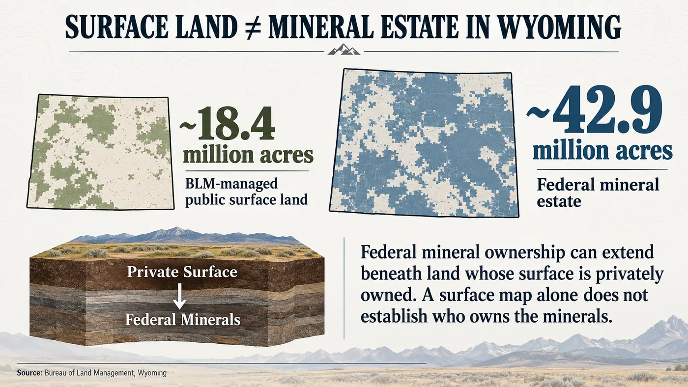
Wyoming also presents an important land-status problem: surface ownership and mineral ownership are not always the same. The Bureau of Land Management reports managing approximately 18.4 million acres of public surface land in Wyoming but approximately 42.9 million acres of federal mineral estate. A blank area on a mining-claim map does not establish that the surface is public, that the federal government owns the minerals, or that the land is open to mineral entry.
Free account · No credit card required · Opens directly to the Wyoming map
Staked Maps combines Wyoming mining-claim records with surface-management and field-research layers in one interactive map.
Wyoming Mining Claims at a Glance
49,392
Current / Not-Closed Federal Claim & Site Records
28,189
BLM Disposition: Active
289,940
Historical Claim Records
999
Documented Mineral Occurrences
Mining claim data synchronized: . Records sync from BLM on a regular schedule, not live with every page visit. Mineral-occurrence data checked: September 24, 2026.
What Does a Current Wyoming Mining Claim Record Mean?
Staked Maps uses “current” for federal mining claim and site records that are not marked closed in its reconciliation process. That is not the same thing as the BLM case disposition “Active.” Wyoming's current records can carry several different BLM statuses.
BLM Status
Records
Share of Current Records
Active
28,189
57.1%
Filed
20,481
41.5%
Under Review
704
1.4%
Submitted
18
<0.1%
Current does not mean the same thing as BLM Active. Filed, Under Review, Submitted and any other distinct BLM statuses should not be treated as legally identical to an Active record. Staked Maps reports the source status; it does not independently determine whether an individual claim contains a valid mineral discovery, satisfies all legal requirements or remains legally enforceable. Verify a specific record through BLM MLRS before relying on it.
What Types of Mining Claims and Sites Are Current in Wyoming?
Wyoming's current federal record population is strongly lode-dominant, but it also includes placer claims, Mill Sites and a small number of Tunnel Sites.
41,183
Lode Claims
7,752
Placer Claims
456
Mill Site Records
1
Tunnel Site Records
Claim Type
Current Records
Share of Current Records
Lode Claims
41,183
83.4%
Placer Claims
7,752
15.7%
Mill Site Records
456
0.9%
Tunnel Site Records
1
<0.1%
Lode and placer records describe different forms of mineral location. Mill Sites and Tunnel Sites are separate location types under the Mining Law, not additional mineral commodities. The mix helps describe the character of recorded activity, but it does not determine the commodity being sought and does not establish whether surrounding land is open to new mineral location.
See where Wyoming's current claim records are located
Open the free Wyoming map to inspect recorded claims alongside surface-management boundaries.
Separately, 7,068 current Wyoming records in this snapshot could not be assigned to a county because they have no usable map location in the BLM source data. They are still counted in the statewide total.
Sweetwater County currently contains the largest share of Wyoming's mapped current claim/site records, followed by Fremont County and Converse County. Together, those three counties account for 44.6% of the statewide current/not-closed record population.
Claim concentration shows where federal claim and site records are concentrated. It does not establish mineral potential, mineral ownership, public access or whether nearby ground is open to location.
Remaining Wyoming Counties With Current Mining Claim Records
This comparison uses each county's current Lode and Placer records only. Placer share is Placer ÷ (Lode + Placer), and lode share is Lode ÷ (Lode + Placer); Mill Site and Tunnel Site records are left out of that denominator. Only counties with at least 50 current Lode and Placer records are compared.
Most placer-oriented: Park County, where 100.0% of 148 current Lode and Placer records are placer claims.
Most lode-oriented: Campbell County, where 100.0% of 3,882 current Lode and Placer records are lode claims.
Largest placer count: Big Horn County, with 2,500 current placer records.
Largest lode count: Fremont County, with 8,162 current lode records.
Mill Sites and Tunnel Sites: Sweetwater County holds 410 of Wyoming's 457 current Mill Site and Tunnel Site records (89.7%).
These are counts of recorded claim types, not commodities. A placer-heavy county is not necessarily a gold county, and a lode-heavy county is not necessarily a uranium or metals county. County figures include only records that could be placed in a county; 7,068 current records have no usable map location and are not included.
Research Sweetwater, Fremont and Converse counties on the map
Move from statewide totals to the claim locations and land context for the area you are researching.
Current and Historical Claims Answer Different Questions
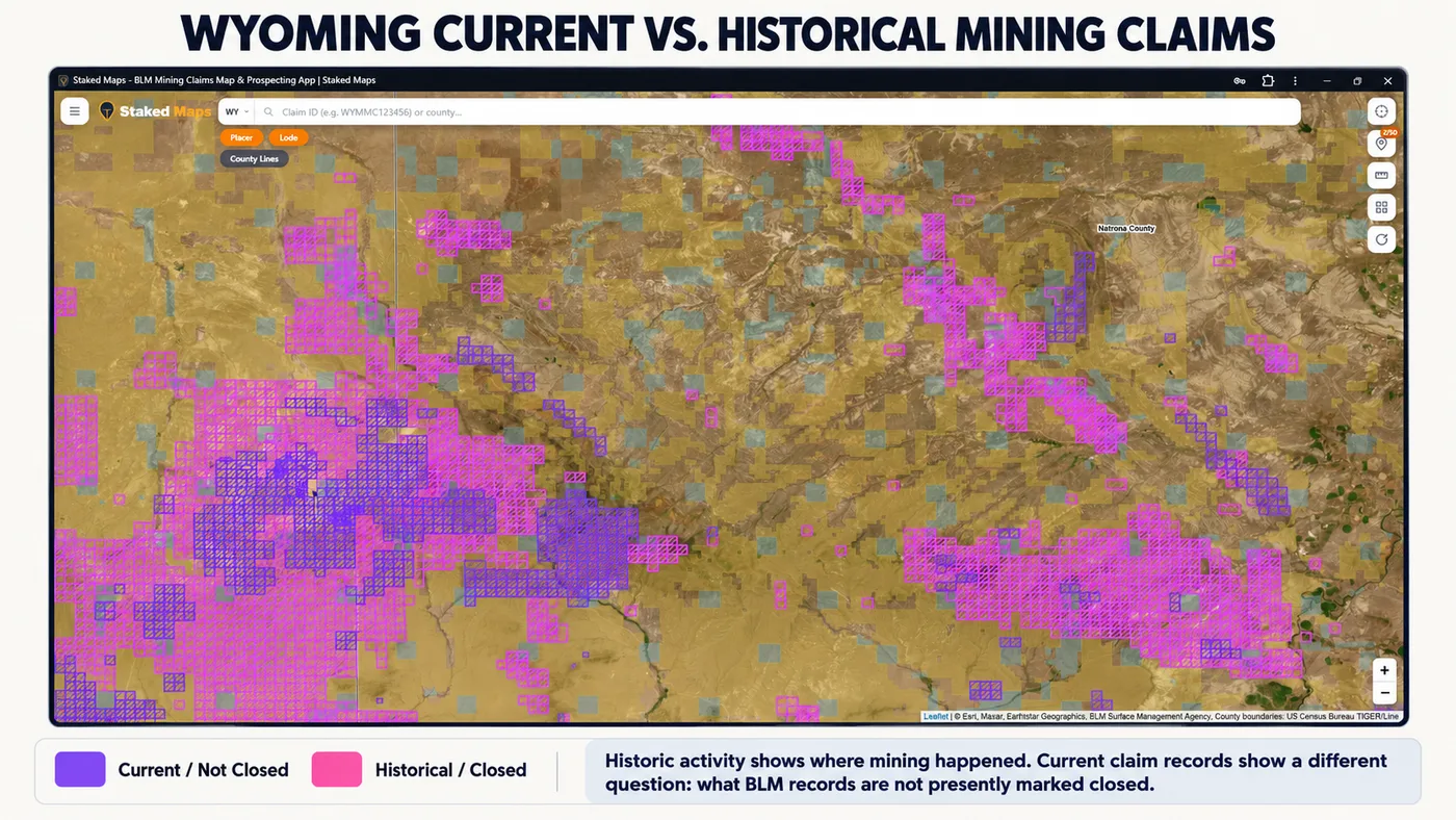
Current/not-closed records help identify federal mining claim and site records that have not been marked closed in Staked Maps' reconciliation process. Historical/closed records show earlier recorded claim activity.
Historical activity can be useful research context because it shows where claim activity occurred in the past. It does not prove that mineral rights remain available, that the land is open to entry, that the public has access or that a historical mine or claim location is safe to enter.
Likewise, the absence of a current claim polygon does not prove that the ground is open to new claim location.
Current/not-closed and historical/closed records answer different research questions. Neither layer by itself determines whether land is legally open to mineral entry.
Why Federal Mineral Estate Is Larger Than BLM Surface Land in Wyoming
The Bureau of Land Management reports managing approximately 18.4 million acres of public surface land and approximately 42.9 million acres of federal mineral estate in Wyoming (BLM, What We Manage: Wyoming). Those numbers are different because surface ownership and mineral ownership are not always the same.
In a split-estate situation, the surface may be privately owned while some or all subsurface mineral rights remain federally owned. BLM specifically documents private-surface/federal-mineral split estate associated with lands patented under laws including the Stock Raising Homestead Act.
That means a surface-management map alone cannot establish who owns the minerals beneath a parcel. It also does not establish whether federal minerals are open to mining-claim location.
BLM reports substantially more federally managed mineral estate than BLM-managed surface acreage in Wyoming. Federal mineral ownership does not, by itself, mean land is open to mining-claim location.
Wyoming State Trust Land Is Not BLM Public Land
Wyoming state trust land is administered by the Wyoming Office of State Lands and Investments (OSLI), not by the Bureau of Land Management. Wyoming received approximately 4.2 million acres of trust land at statehood, and OSLI is required by law to manage state trust lands to produce income to support public schools and other public institutions.
Public recreational use of state trust land is subject to Wyoming's own rules, and the land must be legally accessible. OSLI states that off-road vehicle use, overnight camping and open fires are prohibited on state trust lands, and activities outside the scope of its general recreation rules must be authorized under a temporary use permit or special use lease.
Mineral development on Wyoming state trust land also uses Wyoming's state mineral-leasing system. BLM federal mining-claim procedures should not be assumed to apply to state mineral estate.
If No Current Claim Appears, Is the Land Open to Staking?
No.
The absence of a current mining-claim record answers only one part of the land-status question. Before treating an area as potentially open to mineral entry, research at least:
mineral ownership
surface ownership and managing agency
federal withdrawals or segregations
special designations and closures
existing rights
state, tribal or private ownership
applicable BLM and land-management records
access restrictions
A blank area on Staked Maps is not a legal determination that land is open, unclaimed, publicly accessible or available for prospecting. For how owning minerals differs from holding a claim, see Mineral Rights vs. Mining Claims.
A Wyoming Mining-Claim Map Does Not Show Every Kind of Mineral Development
Wyoming has major coal, oil and gas, uranium, bentonite, trona and other mineral resources. Not every form of mineral development is represented by a federal mining-claim polygon. Different commodities and land interests can be administered through leasing, permitting or other federal and state systems.
For that reason, use the Staked Maps claim layer for mining-claim research, not as a statewide inventory of every mine, mineral lease, mineral right or permitted mineral operation.
Wyoming's Mineral Geography Is More Than a Gold Story
Wyoming's modern mineral geography includes major uranium districts as well as precious metals, base metals, industrial minerals and gemstones. The Wyoming State Geological Survey documents uranium deposits in areas including the Powder River, Great Divide, Wind River and Shirley basins, along with additional districts elsewhere in the state.
Modern Wyoming uranium production uses in-situ recovery rather than conventional hard-rock mining; WSGS reports that it has been the only uranium extraction method used in the state since 1993.
Mining-claim type does not identify commodity. A Lode or Placer record should not be labeled a “uranium claim,” “gold claim” or any other commodity-specific claim unless the underlying source record independently supports that conclusion.
This history is useful research context, but historic mining districts are not current land-status boundaries. Historical mining activity does not establish current claim ownership, public access, mineral ownership or whether ground is presently open to mineral entry.
Wyoming Documented Mineral Occurrences
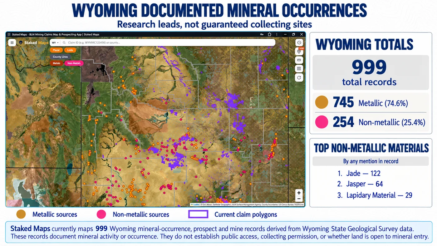
Staked Maps currently maps 999 Wyoming mineral-occurrence, prospect and mine records derived from Wyoming State Geological Survey data. These records are research leads, not a directory of verified public collecting sites.
745
Metallic-classified records
74.6%
254
Non-metallic / gem-lapidary-classified records
25.4%
These two groups follow the classification Staked Maps applied when building this layer from WSGS data: a record is grouped as non-metallic / gem-lapidary if WSGS flags any gem or lapidary material there, and as metallic otherwise. They are not a perfect commodity taxonomy. In the data checked September 24, 2026, 57 of the 254 records in the non-metallic / gem-lapidary group also flag a metal, including 31 that list gold.
Leading Wyoming Gem and Lapidary Materials
Counts below are records that list each material (data checked September 24, 2026). A record can list more than one material, so the rows do not add up to 254.
Material
Records Listing Material
Jade
122
Jasper
64
Lapidary Material
29
Other Gemstones
23
Garnet
15
Kimberlite Indicator Minerals
12
Beryl
6
Corundum
6
Diamond
6
“Other Gemstones” is an unspecified gem category, while “Lapidary Material” is a broader cutting-and-polishing material category. These labels are useful for finding source records but do not identify a specific mineral species.
Mineral-occurrence records do not establish public access, collecting permission, mineral ownership, the absence of a mining claim or whether land is open to mineral entry.
Wyoming mineral-occurrence records shown with current claim and surface-management context. Research the underlying land status before field use.
Who Handles Mining Claims, Land Status and Mining Regulation in Wyoming?
Question
Agency / Record Source
What It Handles
Federal mining claims & federal mineral estate
Bureau of Land Management
Federal mining-claim records, federal mineral estate and federal land-status/withdrawal research.
State trust land & state mineral leasing
Wyoming Office of State Lands and Investments
State trust surface lands, state mineral interests and applicable state mineral leasing.
Mining & reclamation permits
Wyoming Department of Environmental Quality, Land Quality Division
Mining, licensing, permitting and reclamation requirements within its jurisdiction. Does not administer federal mining claims.
Geology & mineral resources
Wyoming State Geological Survey
State geology, mineral resources, historic mining districts, uranium and other mineral-resource research.
National Forest surface management
U.S. Forest Service
Surface-management requirements on National Forest System lands.
Private deeds & title records
Applicable Wyoming county records
Deeds, title history and recorded private-property/mineral reservations where applicable.
Different records answer different questions. A BLM mining-claim record does not substitute for a title search, and a surface-management layer does not establish mineral ownership.
Official Wyoming Mining and Land Research Resources
U.S. Forest Service: surface-management requirements and restrictions on National Forest System lands.
How Staked Maps Builds the Wyoming Mining Claims Map
Staked Maps processes publicly available Bureau of Land Management claim records and synchronizes them into a map designed for field research. It is not a substitute for the official record.
Current/not-closed records: Records in Staked Maps' current dataset that have not been marked closed through the reconciliation process. Synced from BLM's MLRS/NLSDB ArcGIS service through nightly incremental sync plus periodic full reconciliation.
BLM disposition: Retained separately as source data from BLM and may include Active, Filed, Under Review, Submitted or other BLM statuses present in the current source data. BLM case-type values are normalized into Lode, Placer, Mill Site and Tunnel Site.
Historical claims: Sourced from BLM's historical/closed-claims layer. Staked Maps does not represent its local historical cache as a complete archival mirror of every BLM record.
Sync schedule: Nightly incremental sync, a weekly full reconciliation, and a monthly cross-check against BLM's closed-claims layer.
Claim geometry: Claim polygons are derived from legal land descriptions under the Public Land Survey System. Some source records can be represented at coarser aliquot or section-level resolution rather than as surveyed claim footprints. Where BLM supplies no polygon, Staked Maps draws an approximate rectangle from the record's legal description; this includes Wyoming records whose BLM range is written in a nonstandard form (for example “0102W” for Range 102 West), which Staked Maps places using BLM's own PLSS township boundaries.
Counties: County assignment is a spatial match against U.S. Census TIGER/Line county boundaries, not a county field supplied directly by BLM. 7,068 Wyoming current records have no usable map location in the BLM source data yet, so they cannot be assigned to a county; they are still counted in statewide totals.
Rockhound / mineral data: Sourced from Wyoming State Geological Survey. Staked Maps keeps 999 of WSGS's mineral records: those flagging a metal or a gem/lapidary material, excluding industrial and energy commodities such as coal, trona, bentonite and aggregate. These are occurrence, prospect and mine research records, not verified public collecting sites.
Land / PLSS: Public Land Survey System and surface-management research layers use the site's existing published government GIS sources.
Limitations: Staked Maps does not establish legal claim validity, mineral ownership, surface-access rights, title, collecting permission or whether land is open to mineral entry. Verify the applicable official records before relying on a location.
A Practical Wyoming Mining-Claim Research Workflow
Identify the Wyoming area you want to research.
Review current claim/site records and BLM status.
Compare claim types, historical records and mineral-occurrence context where useful.
Determine the surface manager and investigate mineral ownership separately.
Check withdrawals, special designations, state trust land and other restrictions that may affect mineral entry or access.
Verify the applicable BLM, state, county or land-management record before relying on the result.
Staked Maps helps bring map-based research layers together. It is not a legal determination, title search, proof that land is open or proof that land is unclaimed.
Research Wyoming Mining Areas in Staked Maps
See current mining-claim records alongside surface-management, PLSS, historical-claim and mineral-occurrence layers in one map-based research workflow.
Save the Wyoming area you need while you still have service, then use your downloaded Staked Maps view in the field when connectivity is unavailable. Offline map downloads are included with paid plans. See plans below →
What Premium Adds to Your Wyoming Map
Historical Claims. See where mining activity existed before today's current records.
Full Claim Details. Serial number, legal location and direct BLM-record access where available.
Research Layers. PLSS, roads/trails, waterways and Wyoming mineral occurrences.
Offline Maps. Save your Wyoming research before losing cell service.
Field Tools. Directions, custom pins, measurements and claim-drafting tools.
Single State unlocks all premium features for Wyoming for $29.99/year.
Plans
Choose Your Plan
Basic
Free
Try Staked Maps in one state.
$0/mo
✓Interactive mining claims map — pick your state (or use your location)
✓Surface management overlays & current mining claims
✓Claim type, name, status & size in claim popups
Paid plans unlock full claim details, historical claims, research layers and offline tools.
Single State, Tri-State and All-West all unlock the exact same features — nothing is pay-gated between them, they differ only in how many states you get.
Paid plans renew automatically at the monthly or annual rate you choose until you cancel. Cancel anytime and keep access through the end of your paid period. See our Terms of Use.
Single State, Tri-State and All-West unlock the identical feature set — only the number of states differs.
National Rockhound Pass is a separate, nationwide-but-lighter product built for rockhounds outside the core mining states.
Free
Single State
Tri-State
All-West
Rockhound Pass
Geographic coverage
1 state (view only)
1 state, full data
3 states, full data
13 Western states, full data
All 50 states, safety layer only
Interactive claims map, basemaps, compass, county search
✓
✓
✓
✓
✓
Surface management (public/private land) overlay
✓
✓
✓
✓
✓
Claim type, name, status & size in popups
✓
✓
✓
✓
✓
Full legal location (aliquot description)
✕
✓
✓
✓
✕
Claim serial number, owner intel, BLM Records & 'Directions' button
✕
✓
✓
✓
✕
Search by claim number
✕
✓
✓
✓
✕
Custom pins & distance measure tool
✕
✓ (up to 50)
✓ (up to 50)
✓ (up to 50)
✓
Expired & historical claims layer
✕
✓
✓
✓
✕
Placer/Lode claim filters & latest synchronized data
What's the difference between active and historical claims?
Staked Maps displays the status reported by BLM. Records with a case disposition of Active are labeled Active; historical records come from BLM's closed-claims dataset. These statuses are research information, not a Staked Maps legal determination of claim validity, discovery, ownership or compliance. Verify the current record through MLRS before acting on it.
Where are most mining claims in Wyoming?
Wyoming's current federal mining-claim records are concentrated in a handful of counties. As of the data date above, Sweetwater County ranks first, followed by Fremont County and Converse County. Together, those counties account for about 45% of Wyoming's current mapped claim/site records. Claim concentration indicates recorded mining activity, not whether adjacent land is open for prospecting or whether it has mineral potential.
Which agency manages federal mining claims in Wyoming?
The Bureau of Land Management administers federal mining claims in Wyoming through its Wyoming State Office and the MLRS records system. State trust land and state mineral leasing are handled separately by the Wyoming Office of State Lands and Investments.
How many active mining claims are in Wyoming?
As of September 24, 2026, BLM source records in Staked Maps show 28,189 Wyoming mining claim and site records with a case disposition of Active. Wyoming has 49,392 total current/not-closed federal claim and site records when other non-closed BLM statuses are included. 'Current/not-closed' and BLM 'Active' are not the same thing.
What does "current/not-closed" mean in Staked Maps?
It means the record is in Staked Maps' current dataset and has not been marked closed through the reconciliation process. The underlying BLM disposition is shown separately and may be Active, Filed, Under Review, Submitted or another source status.
Does an empty area on the Wyoming claim map mean the land is open to staking?
No. A missing current claim is only one part of the research. Mineral ownership, withdrawals, surface management, state or private ownership, special restrictions and whether the federal mineral estate is open to mineral entry must still be checked.
Why does Wyoming have more federal mineral estate than BLM surface land?
Surface and mineral ownership can be separated. BLM reports approximately 18.4 million acres of managed public surface land in Wyoming and approximately 42.9 million acres of federal mineral estate. Some federal minerals lie beneath surface land owned or managed by someone else.
What are Wyoming's documented mineral occurrences?
They are mineral-occurrence, prospect and mine records derived from Wyoming State Geological Survey data and used as research leads in Staked Maps. They are not a directory of guaranteed public collecting sites and do not establish collecting permission or land status.
Can I search Wyoming by claim number?
Free users can search by county. Paid mining plans add claim-number search and additional claim details, including legal-location and BLM-record information where available.
Does Staked Maps cover all of Wyoming?
Yes. The interactive map covers Wyoming statewide. Dedicated county research pages are available for selected Wyoming counties, while the map itself is not limited to those county pages.
Where does Staked Maps get Wyoming mining-claim data?
Staked Maps uses Bureau of Land Management mining-claim source records synchronized into its own research database. BLM remains the official source for verifying a specific federal mining-claim record.
Information hosted on Staked Maps is compiled from publicly available data
streams provided by the Bureau of Land Management (BLM) and relevant state
geographic clearinghouses. Staked Maps accepts no liability for the content of
this geospatial data, or for the consequences of any real-world exploration,
land entry, or staking actions taken on the basis of the information provided
via this application interface.
Staked Maps makes no warranty, expressed or implied, including the warranties of
merchantability and fitness for a particular purpose, nor assumes any legal
liability or responsibility for the pinpoint accuracy, reliability, completeness,
latency, or programmatic utility of these geospatial data layers, or for the
improper interpretation of these data grids.
These mapping layers and related graphics are visual convenience aids only; they
are not legal documents and must never be used as such. The data may not be used
to legally determine title, mineral ownership, valid description boundaries,
jurisdictional authorities, or land restrictions in place on public or private
land. Natural backcountry hazards may or may not be depicted on topographies, and
land users are strictly mandated to exercise caution. Federal records are dynamic
and change constantly. The end-user is exclusively responsible for validating
current land classifications with the BLM Wyoming State Office and field offices, or the Wyoming Office of State Lands and Investments for state trust land and managing compliance
accordingly.