

Most claim research ends up in pieces. A claim popup you took a screenshot of. Coordinates texted to yourself. A notes app with half a plan in it. A BLM record open in a browser tab on a computer you left at home. Then you reach the trailhead, the phone shows no bars, and the one detail you needed is somewhere you can't reach.
There's a second problem that starts after you leave. Claim records keep changing. A claim you ruled out can close, and someone can stake ground you were planning to come back to. Unless you check the records again, you won't know.
My Research is the research workspace in Staked Maps that keeps all of it together. You build a project for each area you're investigating and save claims, pins, research areas, offline maps, notes and claim drafts to it. The project syncs automatically to every device you're signed in to, so the research you did on your computer is on your phone when you head out, and it opens without cell service.
Claim Sluice, the monitoring side of My Research, checks the claims and areas you're watching each night against updated BLM and Alaska DNR claim records and tells you when something changes. My Research is included with the Single State, Tri-State and All-West plans, with the same features on all three.
Research at Home, Open It in the Field
My Research saves to your Staked Maps account and to the device you're using at the same time. Syncing happens automatically whenever you're connected, and changes usually reach your other signed-in devices within a few seconds. You don't need to start it yourself, although a Sync now option is there if you want it.
A typical week looks like this:
- At home on your computer, you find a stretch of creek, save the claims along it, draw a research area around the ground you care about, drop pins on a turnout and a gravel bar, and write notes.
- On your phone, the same project is already there. You download the offline maps you'll need while you still have a connection.
- In the field with no signal, you open the project, look at your saved claims and notes, and add what you find. Those edits are saved on the phone.
- Back in range, the phone sends your field notes to your account, and they show up on your computer.
If two devices change the same item while one of them is offline, nothing is silently thrown away. The earlier version is kept under Older Edits so you can review it and decide which to keep.
Three things to know before you go out of service:
- Offline maps are downloaded per device. Your account remembers which offline maps belong to a project, but the map files themselves have to be downloaded on each phone, tablet or computer where you want to use them.
- Saved research works offline; new information doesn't arrive offline. Claim Sluice alerts, research area claim counts and current claim statuses all need a connection to update.
- The map layers you see offline come from your downloads. Claim boundaries, surface management, topography and trails are available offline for the areas you downloaded.
One Project for Each Piece of Ground
A project holds everything about one area. You can have up to 25 projects, and anything you haven't filed in a project waits in Unfiled. Each project can hold:
- Saved claims (up to 200 across your account). Each saved claim shows its current recorded status, and the card tells you when a claim has closed since you saved it.
- Pins (up to 50) with a short note, like "Turnout parking" or "Gravel bar above the bend."
- Research areas. A whole township, chosen sections (up to 36), or an area you draw on the map. Each area shows how many current claims are mapped in or near it and how many were new, closed or changed in the last 30 days. You can save up to 10 research areas for each state in your plan.
- Offline maps tied to the project, so you know which downloads go with which trip.
- Notes. One long note per project (up to 10,000 characters). Claim numbers and pin coordinates in your notes become links that take you to that spot on the map.
- Claim drafts from Draft A Claim. These are planned claim layouts saved for your own reference, not anything filed with BLM.
Claim Sluice: Know When Claim Records Change
Claim Sluice watches your saved claims and research areas for you. New saves and new research areas are watched automatically, and each one has a switch if you'd rather not watch it. You can watch up to 100 saved claims plus every research area you've saved.
Each night, after Staked Maps processes the latest BLM claim records and Alaska DNR state claim records, Claim Sluice compares them with what you're watching. It flags three kinds of changes:
- New claim records in a watched research area. A claim that appears in the records for the first time and is mapped in or near your area.
- Status changes on a watched claim. A change to the claim's recorded status in BLM or Alaska DNR records.
- Confirmed closures. A watched claim that the records now show as closed.
Alerts appear in My Research. When a watched claim closes, you can choose Watch this ground instead, which turns the claim's location into a research area in the same project. That matters because anyone who stakes that ground later does it with a new claim, and a new claim gets its own new serial number. Watching the area catches those new claims; watching the old claim number wouldn't.
What Claim Sluice can and can't tell you:
- "New" means newly showing in the records. Federal rules give a claimant until the 90th day after locating a claim to file it with BLM (43 CFR 3833.11(a)), so a claim that appears in your alerts may have been staked on the ground weeks earlier.
- A closure doesn't mean the ground is open. It means that claim is closed in the records. Whether the land is open to new claims still depends on land status, withdrawals and any other claims, which you confirm with BLM and the county.
- It runs once a night. A change shows up after the nightly update that brings it into the records.
The Cleanup: One Weekly Email, Only When There's Something to Report
The Cleanup is an email sent on Thursday mornings (Pacific time) that summarizes watched activity you haven't already been emailed about, grouped by project, with links that open each claim on the map. Weeks with nothing to report send nothing.
The first time you start watching a claim or area, Staked Maps asks whether you'd like The Cleanup, with the box already checked. You can uncheck it then, turn it off anytime in Claim Sluice, and every email includes an unsubscribe link.
With The Cleanup on, you also get one reminder each August before the BLM annual maintenance fee deadline. Holders of federal mining claims and sites have to pay the annual maintenance fee, or file a small miner's waiver if they qualify, on or before September 1 every year, and BLM says missing it subjects the claims to forfeiture. The reminder links to BLM's annual maintenance fee page, which explains the fee, the waiver and how to pay. Alaska state claims (Alaska DNR) follow Alaska's own rules and dates.
An Example Project From Start to Finish
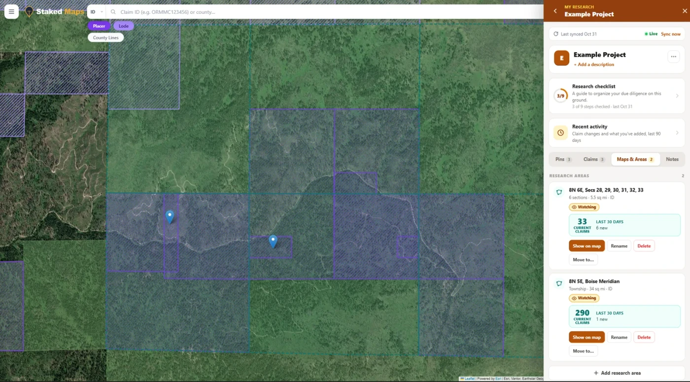
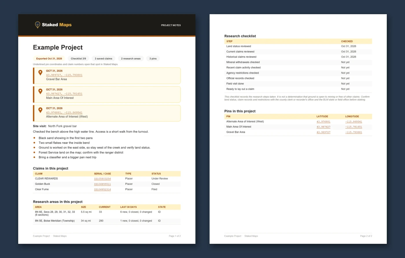
Here's how the pieces work together, using the Example Project shown in this article's screenshots. The ground is real (Boise Meridian, Idaho); the notes are sample notes written for this example.
- Find the ground. On the map, the Placer filter shows current placer claims along a creek drainage.
- Start a project and add research areas. One area covers sections 28 to 33 of Township 8 North, Range 6 East. The other covers all of Township 8 North, Range 5 East. On October 31, 2026, they showed 33 and 290 current claims, with 6 new and 1 new in the previous 30 days.
- Save the claims that matter. Three placer claims went into the project. One was already closed in BLM's records when it was saved. It stays in the project for its history, and the research areas around it will flag any new claims staked on that ground.
- Work through the research checklist. Land status, current claims and historical claims are checked off. Withdrawals, agency restrictions and the official records come next, before any field visit. If you're new to checking records, How to Find Out if a Mining Claim Exists walks through the official sources.
- Drop pins and write notes at home. Three pins mark the main area of interest, an alternate area to the west, and a gravel bar.
- Take it into the field. The project is already on the phone. With the offline maps downloaded, the pins, claims and notes are all there without signal, and the site visit notes go straight into the project.
- Keep watching. Back home, the notes sync to the computer, and Claim Sluice keeps checking both areas and the saved claims every night.
Already on Single State, Tri-State or All-West? Open My Research to start a project. New to Staked Maps? Explore what My Research includes, or compare plans.
Explore My Research Open My Research Compare PlansChecklists, Activity History and PDF Reports
The research checklist is a nine-step guide to due diligence on a piece of ground:
- Land status reviewed
- Current claims reviewed
- Historical claims reviewed
- Mineral withdrawals checked
- Recent claim activity checked
- Agency restrictions checked
- Official records checked
- Field visit done
- Ready to lay out a claim
You can add up to five steps of your own. The checklist records the steps you've taken. It doesn't decide whether ground is open to mining or free of other claims; the official records do.
Recent activity is a 90-day timeline for each project: claim changes on the ground you're watching, plus what you added and when. It answers "what's happened here since I last looked?" without digging through each claim.
PDF export turns a project into a report you can print, file or share. It includes your notes, pins, saved claims with their current status, research areas with current claim counts, and the checklist with the date each step was checked. Underlined claim numbers and pin coordinates in the PDF open that spot in Staked Maps. The export fetches current claim statuses and area counts when you make it, so the report reflects the records on the day you export.
Who Gets My Research and How to Start
My Research and Claim Sluice are included with every Staked Maps mining claim plan: Single State, Tri-State and All-West. All three get exactly the same features. The difference between the plans is geographic: your plan's states are where you can add research areas, watch claims and areas, and check current claim statuses.
Free accounts can see what My Research includes, and open the example project, from the My Research section of the app. Using it requires one of the three mining plans.
To start, sign in and open My Research from the menu or the book icon on the map. Create a project, then save claims from their popups, add a research area, or move pins and offline maps you already have into the project.
If your plan ends later, your saved research stays readable and exportable for 12 months, and you'll get an email warning before anything is deleted.
For a look at the kind of claim activity Claim Sluice watches for, see New Mining Claims in the West, our report on where the last 30 days of claim activity landed.
Common Questions
Can I use Staked Maps offline?
Yes. Paid plans support offline map downloads, so claim boundaries, surface management data, topography and trails stay available with no cell service. On Single State, Tri-State and All-West, your saved My Research projects work offline too, and changes you make offline sync when you're back online. Download the maps you need on each device before you head out.
What is My Research?
My Research is the research workspace included with Single State, Tri-State and All-West. Create projects, save claims, pins, research areas and offline maps, keep notes, follow a research checklist, watch claims and areas with Claim Sluice, and export your findings to PDF.
Does my research sync between my computer and phone?
Yes. My Research syncs automatically to your Staked Maps account on every device you're signed in to, whenever you're connected. You can research an area on your computer at home and open the same project on your phone or tablet in the field. Offline map files need to be downloaded on each device where you want to use them.
How does Claim Sluice work?
Claim Sluice checks your watched claims and research areas each night against updated BLM and Alaska DNR claim records. It flags new claims in watched areas, qualifying status changes and confirmed closures. Alerts appear in My Research. The first time you watch something, you're offered The Cleanup, a weekly email summary that you can turn off anytime. With it on, you also get a reminder each August before the September 1 BLM annual maintenance fee deadline. Checking for new alerts needs an internet connection, so nothing new arrives while your device is offline.
Before Your Next Trip
The research you do before a trip is only useful if it's with you when you get there and still accurate after you leave. My Research puts the claims, notes, maps and checklist for each piece of ground in one project that's on your phone without signal, and Claim Sluice keeps an eye on the records while you're away. It's a research tool: the official records at BLM and the county still decide what's claimed and what's open, and the checklist is there to make sure you check them.
Open My Research if you're on Single State, Tri-State or All-West. If you're not, explore what it includes or compare plans.
Explore My Research Open My Research Compare PlansThis guide describes My Research and Claim Sluice as of November 6, 2026. Example project figures are from October 31, 2026. The BLM filing deadline was checked against 43 CFR 3833.11 on October 31, 2026, and the annual maintenance fee deadline against BLM's annual maintenance fee page on November 6, 2026.
Sources
- Code of Federal Regulations, 43 CFR 3833.11, Recording mining claims and sites with BLM (filing by the 90th day after location).
- Bureau of Land Management, Annual Maintenance Fees for mining claims and sites (fee or small miner's waiver due on or before September 1), checked November 6, 2026.
- Staked Maps Example Project (screenshots and PDF export, October 31, 2026).