Montana Mining Claims Map: Current BLM Data & Public Land
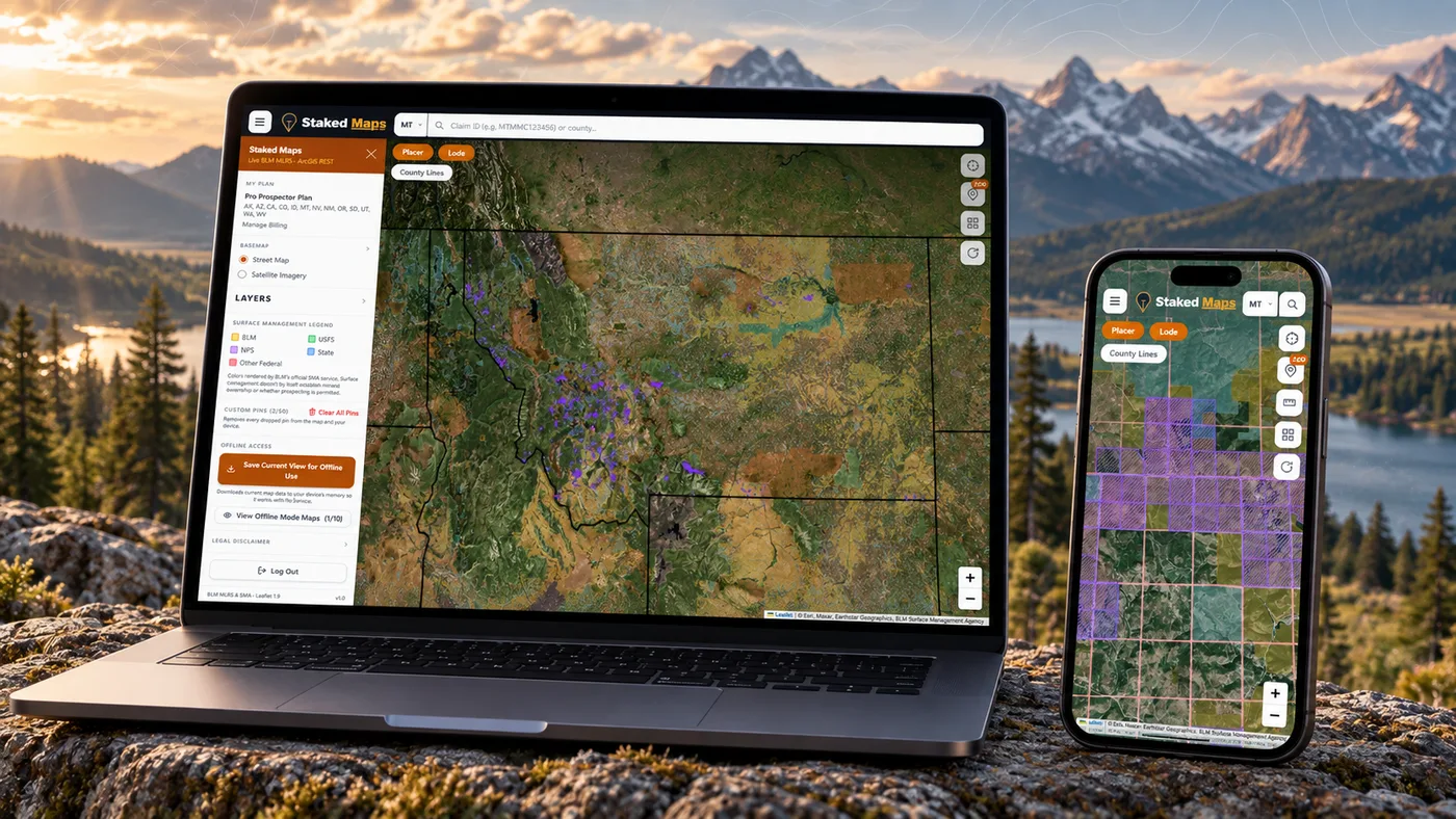
Staked Maps combines current and historical federal mining-claim records from the Bureau of Land Management with public-land research layers for Montana, including surface management, mineral-occurrence data and Montana State Trust Land — a distinct ownership category covered in detail below.
As of September 22, 2026, Staked Maps shows 20,737 current federal claim and site records and 226,935 historical records for Montana, plus 8,776 documented mineral-occurrence records. An area with no current claim shown is not, by itself, proof that the ground is open — that distinction is covered further down this page.
Free account · No credit card required · Opens directly to the Montana map
Montana Mining Claims at a Glance
20,737
Current Federal Claim & Site Records
226,935
Historical Claim Records
8,776
Mineral Occurrence / Rockhound Records
Mining claim data synchronized: . Federal BLM claim records synchronize on a regular schedule, not live with every visit.
How Many Montana Mining Claims Are BLM-Status Active?
The current Montana dataset presently contains Active, Filed, Under Review and Submitted records; Staked Maps groups these together as current/not-closed. That grouping isn't the same thing as BLM's own "Active" status label, and treating the two as interchangeable overstates how many Montana records have fully cleared BLM's review.
BLM Status
Records
Share of Current Records
Active
20,221
97.5%
Filed
484
2.3%
Under Review
30
0.1%
Submitted
2
<0.1%
Why this matters: at the latest synchronization, 20,737 Montana records are current/not-closed, but only 20,221 of those (97.5%) carry BLM's own Active case disposition. Another 484 (2.3%) are Filed, 30 (0.1%) are Under Review, and 2 are Submitted. Filed, Under Review and Submitted records have a pending BLM case action and shouldn't be treated as identical to a fully Active claim. Verify a specific claim's exact status through BLM MLRS before relying on it.
Montana Lode, Placer, Mill Site & Tunnel Site Claims
Montana's current federal dataset is not just lode and placer claims. Mill site and tunnel site records are a genuine part of the total — the previous version of this page counted only lode and placer, which is why its own numbers never reconciled to its headline claim count. Staked Maps includes every current Montana claim/site type in the source data so the statewide total adds up.
16,209
Lode Claims
3,084
Placer Claims
1,416
Mill Site Claims
28
Tunnel Site Claims
Lode claims cover valuable mineral deposits occurring in rock in place, such as a vein or lode. Placer claims cover valuable mineral deposits in loose material — gravel, sand or similar — rather than a vein in place. A placer claim is generally limited to 20 acres per locator, but federal law also allows an association placer claim of up to 160 acres when eight or more locators join it — a flat 20-acre cap doesn't apply to every placer claim. Mill sites support ore-processing operations and tunnel sites support underground access; both are located separately from lode and placer ground and aren't the same type of claim. Montana's 16,209 lode, 3,084 placer, 1,416 mill site and 28 tunnel site records add up to the full current total of 20,737. See the official BLM Mining Claims resource.
Montana Claims by Type, Visualized
Claim Type
Current Claims
Lode Claims
16,209 (78.2%)
Placer Claims
3,084 (14.9%)
Mill Site Claims
1,416 (6.8%)
Tunnel Site Claims
28 (0.1%)
See where Montana's current claim records are located
Open the free Montana map to inspect recorded claims alongside surface-management boundaries.
The table shows Montana's 10 counties with the most current records. Separately, 2,227 records in the statewide total cannot currently be assigned to a specific county because their BLM source geometry is incomplete or unresolved.
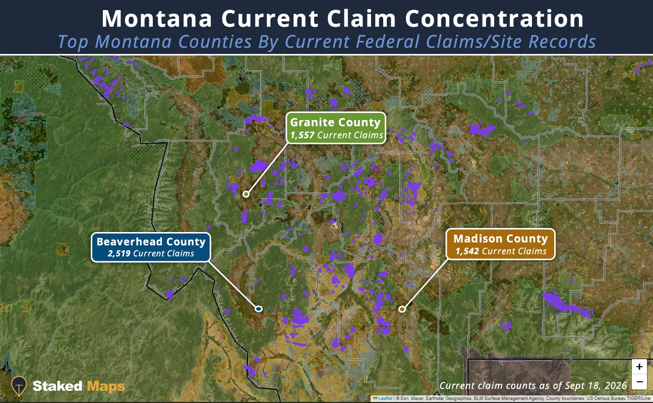
Montana's three leading counties by current federal claim/site records, in Staked Maps.
Montana's current records concentrate in a relatively small number of counties. Beaverhead County leads with 2,519 current records (12.1% of the statewide total), followed by Granite County (1,557, 7.5%), Madison County (1,542, 7.4%), Sweet Grass County (1,486, 7.2%) and Lincoln County (1,432, 6.9%). Together these five counties hold 41.2% of Montana's current statewide total (8,536 of 20,737).
Montana's dataset also includes 2,227 current records, about 10.7% of the statewide total, that BLM's own source geometry can't resolve to a specific county boundary. Those records are counted in the statewide total above but not in any county's row in the table, which is why the county rows don't sum to the full statewide figure.
Claim-type composition differs sharply by county. Beaverhead (95.7% lode) and Granite (95.2% lode) are both dominated by hard-rock lode claims, consistent with hard-rock mining activity in both counties (see the geology section below for local context) — though claim type alone doesn't identify which commodity or project drives that pattern. Lincoln County stands apart: 855 of its 1,432 current records (59.7%) are mill site claims, a far higher mill-site share than any other leading county, consistent with modern underground development in the Cabinet Mountains rather than a historic gold-placer pattern — again, the claim data doesn't identify the specific project.
Claim concentration is not a measure of mineral richness or value. A dense cluster of current federal records shows where claims and sites are concentrated in the BLM dataset. It does not prove production, mineral value, legal access, or that nearby unclaimed-looking land is open to mineral entry.
Remaining Montana Counties With Current Mining Claim Records
Montana's map is a mix of several different land-management contexts, and they don't work the same way. Seeing public land on a map does not, by itself, tell you whether it's open to mineral entry, and seeing no current claim does not mean the ground is available to stake.
Context
What It Actually Tells You
BLM-managed surface
BLM manages the surface. Locatable federal minerals may or may not be open to entry at that specific location — withdrawals and other restrictions can still apply.
National Forest System land
The U.S. Forest Service manages the surface. Much of it sits over federal mineral estate that is open to mining claims, but not all of it, and USFS applies its own surface-use rules to any mining activity.
Montana State Trust Land
Managed by DNRC for the benefit of public schools and other trust beneficiaries — not ordinary federal public land. Covered in its own section below.
Private surface
Access and mineral ownership require permission and separate verification from the landowner, regardless of who (if anyone) holds the mineral rights.
Split estate
Surface ownership and mineral ownership don't always match. Montana's State Trust Land is the clearest statewide example (see below), but split estates also occur on some private and federal land.
Use the map to research. Use official records to verify.
Staked Maps shows recorded claim activity and surface-management context in one place. It does not determine that a parcel is open to mineral entry, available for claim location, accessible across surrounding land, or free of withdrawals and other restrictions.
Does No Mining Claim Mean the Ground Is Open?
No. An area with no current mining claim record is not automatically open to mineral entry. A blank spot on Staked Maps' claim layer only means the source BLM data doesn't show a current claim there — it says nothing about several other questions that still need answers:
The mineral estate at that location may not be federal locatable mineral estate at all — it could be state-owned (Montana State Trust Land), privately owned, or a leasable mineral like phosphate or coal rather than a locatable one.
Land or minerals can be withdrawn or reserved from mineral entry even where no claim is currently on file.
Special land designations — wilderness study areas, areas of critical environmental concern, and similar restrictions — can limit or bar new claim location.
State or private mineral interests can apply even where the surface looks like ordinary public land.
An apparently empty claim layer reflects Staked Maps' own synchronized dataset, not an official BLM determination that the ground is available.
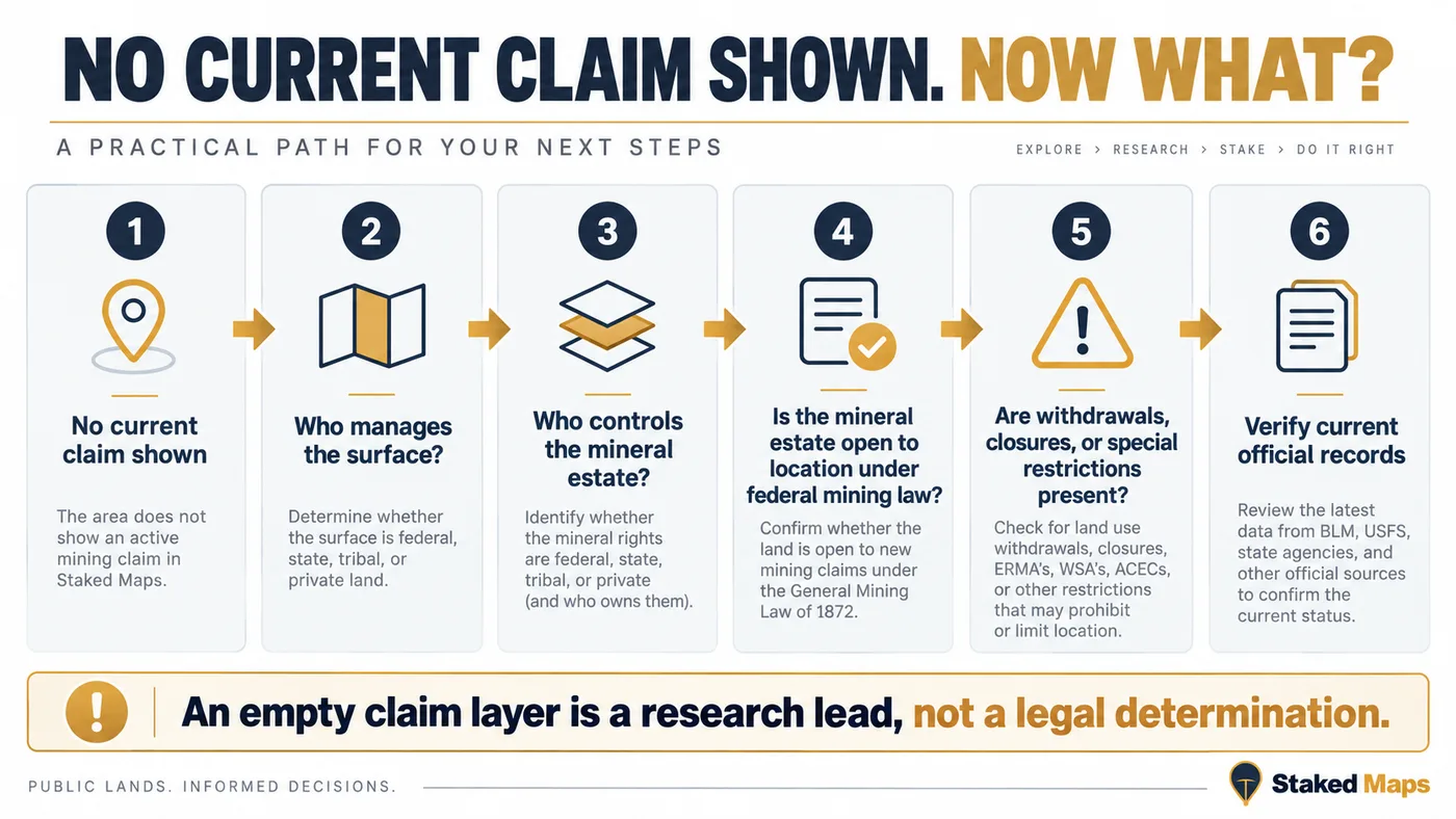
A practical research path for ground with no current claim shown — see the full workflow section below.
An empty claim layer is a research lead, not a legal determination. Treat it as the start of land-status research, not the end of it.
Why Montana State Trust Land Requires Extra Research
Montana State Trust Land is one of the most misunderstood categories on a Montana map, and it isn't simply interchangeable with ordinary federal public land. The Montana Department of Natural Resources and Conservation (DNRC) manages Montana's trust lands under a constitutional mandate: generating revenue for public schools and other state institutions, primarily through leases, timber and mineral development — not managing land as general-purpose public recreation ground the way BLM or the Forest Service does.
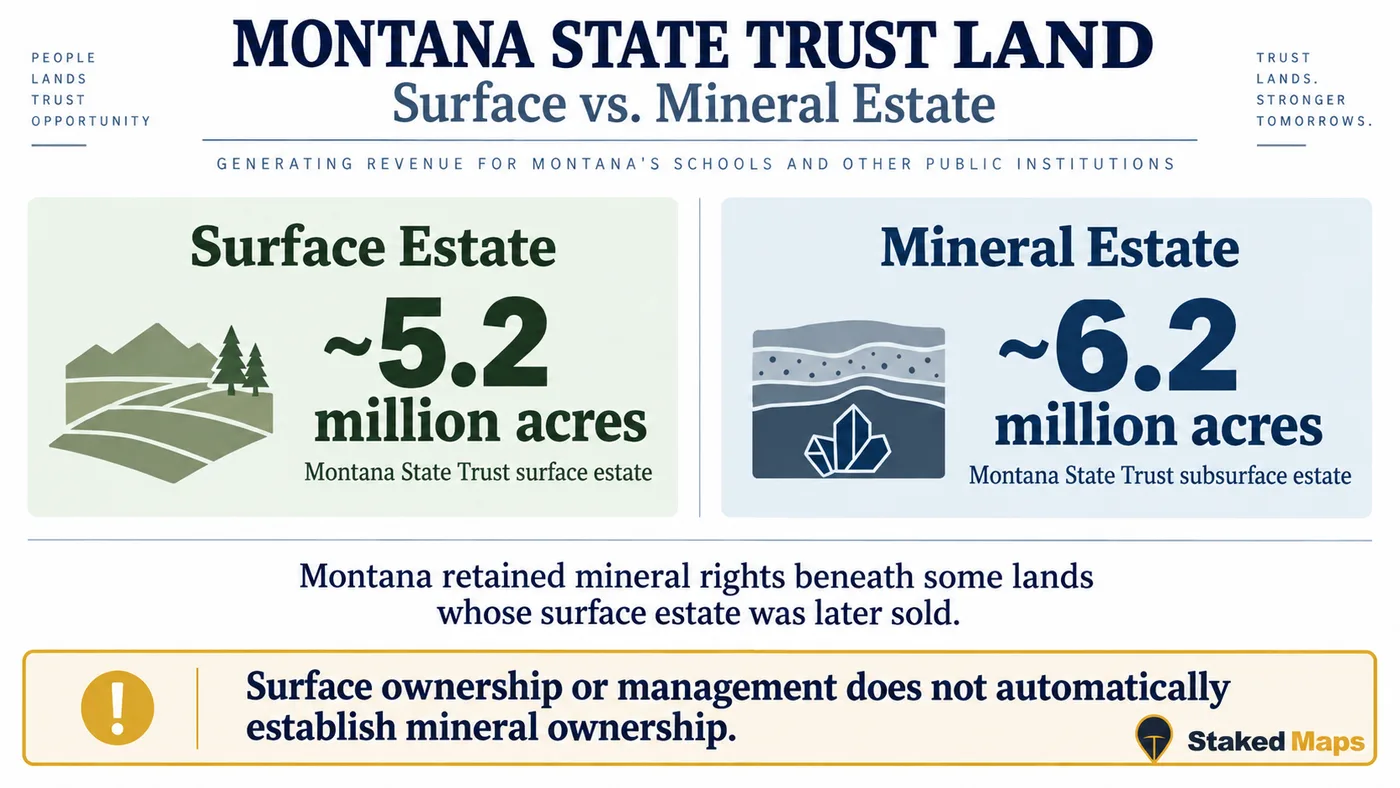
Montana State Trust surface estate (~5.2 million acres) versus subsurface/mineral estate (~6.2 million acres). Source: Montana DNRC.
Surface Ownership and Mineral Ownership Can Differ
DNRC's own figures show why the two acreage totals above don't match: Montana's trust surface estate covers about 5.2 million acres, while its trust subsurface/mineral estate covers about 6.2 million acres — roughly a million acres more. The larger mineral-estate figure reflects mineral rights Montana retained beneath some land whose surface was later sold into private ownership. In plain terms: on some parcels, the state owns the minerals underneath ground it no longer owns (or never owned) on the surface. A surface-management map alone does not establish mineral ownership, and it does not establish whether land is open to mineral entry.
Collecting Rocks or Minerals on Trust Land Needs Its Own Authorization
Most legally accessible Montana trust land is open to general recreation under a Conservation License. Collecting valuable rocks or minerals, and mineral exploration, are not covered by that general recreational-use authorization — DNRC's own recreational use guide lists them, alongside trapping and commercial or group uses, as activities that require separate, additional authorization directly from DNRC. Comprehensive rules are codified at Montana Code Annotated §§77-1-801 through 77-1-815 and Administrative Rules 36.25.143 through 36.25.167.
This is not legal advice.
DNRC has an active administrative-rule review of trust-land recreational use underway, with public comment periods running into late September 2026. Rules referenced here can change. Verify current DNRC rules for the specific land office and activity before collecting, exploring or otherwise disturbing trust land.
How to Research a Potential Montana Prospecting Area
Identify the area in Staked Maps. Start with the current federal claim layer to see what BLM has on record nearby.
Examine current and historical records together. Prior claim activity can point toward a documented mining history without proving current availability.
Identify surface management. Determine whether the surface is BLM, USFS, Montana State Trust Land, or private before assuming anything about the minerals underneath it.
Review the individual BLM case, where one exists. A specific claim's case information and legal description are the authoritative record, not the map polygon alone.
Research mineral estate, land status and withdrawals where the ground looks open. An absence of current claims is a starting point, not a conclusion — see the section above.
Check applicable BLM, USFS or DNRC rules for the specific activity. What's required differs by land manager and by activity (recreational panning is not the same question as mechanized equipment or trust-land mineral collecting).
Verify official records before relying on the result. Staked Maps speeds up the research above; it does not replace BLM MLRS, DNRC, USFS or county records as the official answer.
Free account · No credit card required · Opens directly to Montana
Why Montana's Current Claims Concentrate Where They Do
Montana's current claim concentration lines up with a handful of specific districts — some historic, some still active today — rather than one statewide gold-rush narrative. Historical mineral activity in any of these districts does not establish present-day access, mineral rights, or openness to claim location.BLM claim type (lode, placer, mill site, tunnel site) also does not by itself identify a commodity or a specific project — the district connections below are reasonable hypotheses grounded in known local geology and mining history, not conclusions the claim database itself proves.
Beaverhead County: Bannack Placer Gold and the Ruby Range Talc District
Montana's first major gold strike came at Grasshopper Creek in 1862, drawing prospectors to what became the town of Bannack — now Bannack State Park. That 19th-century placer history sits alongside a very different, still-active mineral industry in the same county: the Ruby Range talc district south of Dillon, hosted in marble along the Ruby Range. USGS data cited by MBMG put Montana's share of U.S. talc mine production at about 40% as of the early 1990s, almost all of it from Ruby Range mines — a more recent statewide percentage isn't published in the sources checked for this page. Beaverhead County's current claim mix (95.7% lode, only 4.2% placer) is consistent with hard-rock mining activity like the talc district far more than the 1862 placer rush — though BLM claim-type data alone doesn't identify talc, or any specific commodity, as the cause of that pattern.
Granite County: Philipsburg Silver and Rock Creek Sapphires
Philipsburg grew up around the Granite Mountain Mine, whose silver ore, discovered in the 1880s, made it one of Montana's richest 19th-century silver producers before the market crashed in 1893. Nearby Rock Creek is a separate, still-collected alluvial sapphire deposit, discovered in the 1890s during gold placer work and now one of the largest sapphire-producing localities in North America. Like Beaverhead, Granite County's current records are overwhelmingly lode claims (95.2%), consistent with hard-rock mining activity rather than placer gravels — again, claim-type data alone doesn't identify silver, sapphire, or any other specific commodity as the reason.
Madison County: Alder Gulch and the Ruby Range
Alder Gulch's 1863 gold strike built Virginia City, which became Montana Territory's second capital in 1865 — Bannack held that role first, from 1864, before Helena took over in 1875. The county's current placer share (12.1%, higher than Beaverhead's or Granite's) still reflects that placer-gravel history. The Ruby Range talc district discussed above also extends into Madison County, contributing to its lode-dominant overall mix.
Sweet Grass County: The Stillwater Complex
Sweet Grass and neighboring Stillwater County sit along the Stillwater Complex, a layered igneous intrusion exposed along the north flank of the Beartooth Mountains. USGS's own Mineral Commodity Summaries identify the Stillwater and East Boulder Mines, both worked within this complex, as the only primary platinum-group-metal production sites in the United States. Sweet Grass County's current claim data is consistent with that ongoing industrial-scale operation: 174 of its 1,486 current records (11.7%) are mill site or tunnel site claims, a far higher share than most Montana counties, matching the kind of infrastructure a modern underground operation requires — though the claim data itself doesn't identify PGM, or any commodity, as what that infrastructure supports.
Lincoln County: Modern Silver-Copper Exploration in the Cabinet Mountains
Lincoln County's current claim mix is the most distinctive in the state: 855 of its 1,432 current records (59.7%) are mill site claims, far more than its 521 lode claims. Lincoln County has a long silver-copper mining history — including the Troy Mine, an underground silver-copper producer south of Troy — and has also seen more recent underground silver-copper project proposals in the Cabinet Mountains. Either can drive a high mill-site count, since a processing operation files mill site claims separately from the lode claims covering the ore body itself; the current data doesn't distinguish which specific project accounts for Lincoln's total.
Staked Maps includes 8,776 documented Montana mineral-occurrence records, drawn from the USGS Mineral Resources Data System (MRDS) — 8,575 classified as metallic and 201 as non-metallic. These records describe mines, prospects and occurrences; which label a given record carries depends on what USGS's source data recorded there, not a Staked Maps judgment call.
Montana's non-metallic materials list is dominated by kyanite, quartz, corundum and garnet — industrial and abrasive minerals more than gem rough — with sapphire also appearing among the state's more commonly recorded materials, consistent with the Rock Creek and Yogo districts discussed above. Staked Maps preserves the underlying MRDS commodity labels as recorded rather than re-sorting them into simplified categories.
A Documented Occurrence Is Not an Authorized Collecting Location
An MRDS record means USGS has documentation of material found at that location at some point. It does not establish current public access, permission to collect, presence of collectible material today, or current land status. If the location falls on Montana State Trust Land, remember that collecting rocks or minerals there needs its own DNRC authorization — see the Trust Land section above.
Source records sometimes use broad or overlapping commodity labels; counts above preserve the underlying record classifications.
Montana Top Rockhounding Materials, Visualized
Material
Sites Recorded
Kyanite
52
Quartz
41
Abrasive, Corundum
17
Gemstone
14
Abrasive, Garnet
14
Gemstone, Sapphire
12
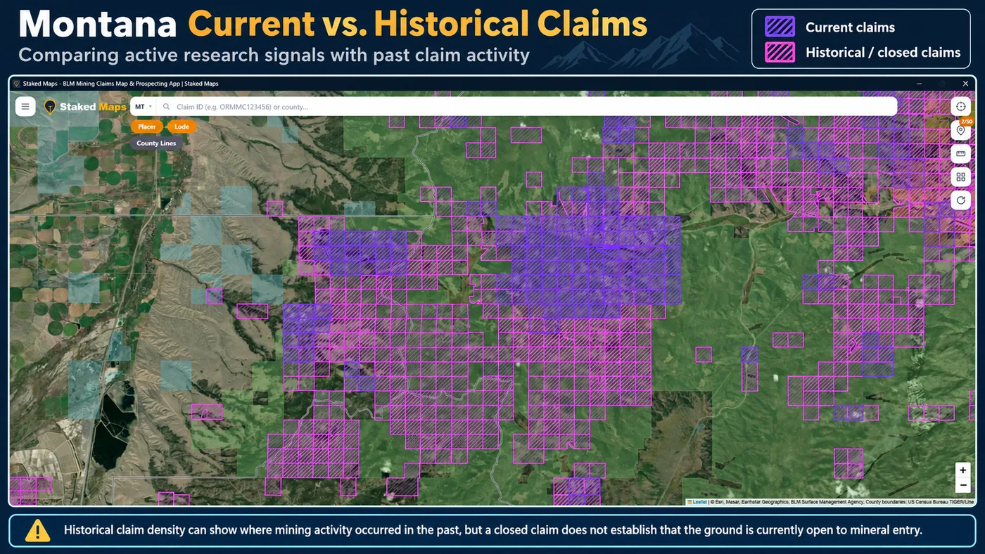
Current vs. Historical Montana Claims
Staked Maps' current dataset (20,737 records) reflects BLM MLRS case dispositions that are not part of BLM's separate closed-claims dataset. The historical dataset (226,935 records) comes from that closed-claims dataset directly — claims and sites BLM itself reports as closed or expired. The two datasets use BLM's own case-disposition field, not a Staked Maps-invented status.
Current (purple) and historical/closed (pink) claim records over the same area of Montana in Staked Maps.
Montana's historical dataset, at 226,935 records, is more than ten times the size of its current dataset — a reminder of just how much ground across Montana has seen some past claim activity. A closed historical claim does not establish that the land is currently open to mineral entry. Prior claim activity can be a useful signal that a district was worked before; it says nothing about today's land status, mineral ownership, or whether new claim location is currently permitted there.
How Staked Maps Builds the Montana Mining Claims Map
Current and Historical Federal Claims
Current Montana claim and site records come from BLM's Mineral & Land Records System (MLRS). "Current" is a Staked Maps grouping, not a BLM status label itself — the Montana dataset presently contains Active, Filed, Under Review and Submitted records under that grouping. See the status breakdown above for the exact split. Historical records come from BLM's own separate closed-claims dataset. Staked Maps synchronizes this data on a regular schedule, not live with every visit; the sync date is shown above.
Mapped Claim Geometry
Staked Maps converts BLM's available legal/PLSS location data into map features for research and field reference. Mapped claim boundaries are not professional cadastral surveys and shouldn't be treated as a legal determination of a claim's exact position. Where exact legal position matters, review the official BLM case record.
Surface Management and Montana State Trust Land
The surface-management layer shows who manages or owns the surface — BLM, USFS, the State of Montana, or private ownership. It does not by itself determine mineral ownership or whether land is open to mineral entry, a distinction that matters most for Montana State Trust Land, where the surface and mineral estates are managed under an entirely different framework than BLM public land (see the Trust Land section above).
Mineral Occurrence Records
Montana's mineral-occurrence layer is derived from the USGS Mineral Resources Data System (MRDS). These are documented occurrences, prospects and mines, not a curated list of legally accessible public collecting sites.
How Staked Maps Fits Into Official Montana Research
Used well, Staked Maps can speed up the early stages of Montana mineral research: visualizing current and historical claim records together, layering surface management alongside claim data, looking up individual claim details and BLM record links, searching by claim serial number on paid plans, reviewing legal/aliquot information where available, and downloading map areas for offline field use.
Staked Maps does not replace BLM MLRS, Montana DNRC, the U.S. Forest Service, county records, a title search, or professional legal advice. It does not verify mineral rights and does not determine legal access. For an official determination about a specific parcel, the responsible agency's own record is the answer — not this page or the Staked Maps map.
Montana Mining Claims Map: What It Can and Cannot Tell You
Can help you
See mapped current BLM mining claim and site records, including Active, Filed, Under Review and Submitted cases.
Compare current and historical claim activity.
Identify recorded claim names and types where available.
Research counties and historic mining areas before a trip.
Navigate saved map areas in the field with applicable paid features.
Cannot by itself
Prove that land is legally open to mineral entry.
Establish mineral ownership or legal title.
Guarantee that every mapped boundary is survey-grade.
Give permission to cross private property.
Give permission to prospect on someone else's valid mining claim.
Replace current BLM, USFS, state or county records.
Determine which mining or in-stream activities require permits.
Use Staked Maps as a research and navigation tool, then confirm legal status with the agencies that manage the land and mineral estate.
How Do You View Montana BLM Mining Claims Offline?
Save any map area while you have cell service, then navigate active BLM mining claims, surface-management boundaries, and optional layers like elevation contours, roads, and creeks — with zero connectivity out in the field. Offline downloads are included on every paid plan. See plans below →
Official Prospecting Resources for Montana
Official Montana Mining and Land Research Resources
Forest Service rules for recreational gold panning and prospecting on National Forest System land in Montana.
Frequently Asked Questions
What's the difference between active and historical claims?
Staked Maps displays the status reported by BLM. Records with a case disposition of Active are labeled Active; historical records come from BLM's closed-claims dataset. These statuses are research information, not a Staked Maps legal determination of claim validity, discovery, ownership or compliance. Verify the current record through MLRS before acting on it.
Can I search by claim number?
Free users can search by county. Paid plans add search by claim serial number, plus each claim's full legal (aliquot) description and BLM records link.
How many active mining claims are in Montana?
As of September 22, 2026, BLM records in Staked Maps show 20,221 Montana mining claim and site records with a case disposition of Active. Another 30 are Under Review, 484 are Filed and 2 are Submitted, bringing Montana's total current/not-closed federal claim and site records to 20,737. These database statuses are not a legal determination that an individual claim contains a valid mineral discovery.
What are Rockhound Hotspots?
A premium map layer of documented mineral occurrences, prospects and mines sourced from USGS MRDS and labeled by material where available. These records are research leads, not a directory of verified public collecting sites.
Where are most mining claims in Montana?
Montana's current federal mining-claim records are concentrated in a handful of counties. As of the data date above, Beaverhead County ranks first, followed by Granite County and Madison County. Together, those counties account for about 27% of Montana's current mapped claim/site records. Claim concentration indicates recorded mining activity, not whether adjacent land is open for prospecting or whether it has mineral potential.
Does the Montana map cover the whole state?
Yes. Staked Maps covers Montana statewide. Dedicated research pages are currently available for Madison County, Granite County, Broadwater County, Jefferson County and Lewis and Clark County, while the interactive map covers claims and surface management throughout Montana.
Which agency manages federal mining claims in Montana?
The Bureau of Land Management Montana/Dakotas office administers federal mining-claim records for Montana through MLRS. Montana DNRC separately administers Montana State Trust Land, including its own mineral leasing and recreational-use authorization rules. See the Official Filing & Information Links section above for direct links to both.
How many current mining claims are in Montana?
Staked Maps currently shows 20,737 current (not-closed) federal claim and site records for Montana. Of those, 20,221 carry BLM's own Active case disposition; the rest are Filed, Under Review or Submitted. See the status breakdown above for the full split.
Does land without a current mining claim mean I can prospect there?
No. An area with no current claim may still be unavailable because of mineral ownership, land withdrawals, special designations, or because it's Montana State Trust Land or private land rather than open federal public domain. Treat a blank area as a place to research further, not proof the ground is open.
Can you prospect on Montana State Trust Land?
General recreation on legally accessible trust land requires a Conservation License, but collecting valuable rocks or minerals and mineral exploration are excluded from that general authorization and require separate, additional approval directly from Montana DNRC. Contact the relevant DNRC land office before collecting or exploring on trust land.
How is Montana State Trust Land different from BLM land?
BLM manages federal public land primarily for multiple use, including mineral entry under the General Mining Law. Montana DNRC manages State Trust Land under a constitutional mandate to generate revenue for public schools and other beneficiaries, mainly through leasing, timber and mineral development. The two are administered under different laws with different rules, and a Montana State Trust Land parcel is not simply a state-flagged version of BLM public land.
Can surface ownership and mineral ownership differ in Montana?
Yes. Montana DNRC's own figures show about 5.2 million surface acres in its trust estate against about 6.2 million subsurface/mineral acres — roughly a million more mineral acres than surface acres — because Montana retained mineral rights beneath some land whose surface was later sold. A surface-management map alone doesn't establish who owns the minerals underneath.
What is the difference between lode and placer claims?
A lode claim covers a valuable mineral deposit in rock in place, such as a vein. A placer claim covers valuable minerals in loose material like gravel or sand. Placer claims are generally capped at 20 acres per locator, though an association placer claim can run up to 160 acres with eight or more locators. Mill site and tunnel site claims are separate claim types that support processing and underground access rather than covering a mineral deposit directly.
Where does Staked Maps get Montana mining-claim data?
Current and historical federal claim and site records come from the Bureau of Land Management's MLRS, synced into Staked Maps' database on a regular schedule. Documented mineral-occurrence records come separately from the USGS Mineral Resources Data System (MRDS). Neither dataset covers Montana State Trust Land mineral leasing, which DNRC administers separately.
Does a historical/closed mining claim mean an area is open?
No. A closed or historical claim shows past claim activity at that location. It doesn't establish current land ownership, mineral-entry status, access rights, or whether the ground can legally be claimed today.
How should I verify a Montana claim or potential prospecting area?
For a specific federal claim, verify directly through BLM MLRS. For Montana State Trust Land questions, contact the relevant Montana DNRC land office. Staked Maps is a research and navigation tool, not the official system of record for either agency.
Single State, Tri-State and All-West all unlock the exact same features — nothing is pay-gated between them, they differ only in how many states you get.
Paid plans renew automatically at the monthly or annual rate you choose until you cancel. Cancel anytime and keep access through the end of your paid period. See our Terms of Use.
Single State, Tri-State and All-West unlock the identical feature set — only the number of states differs.
National Rockhound Pass is a separate, nationwide-but-lighter product built for rockhounds outside the core mining states.
Free
Single State
Tri-State
All-West
Rockhound Pass
Geographic coverage
1 state (view only)
1 state, full data
3 states, full data
13 Western states, full data
All 50 states, safety layer only
Interactive claims map, basemaps, compass, county search
✓
✓
✓
✓
✓
Surface management (public/private land) overlay
✓
✓
✓
✓
✓
Claim type, name, status & size in popups
✓
✓
✓
✓
✓
Full legal location (aliquot description)
✕
✓
✓
✓
✕
Claim serial number, owner intel, BLM Records & 'Directions' button
✕
✓
✓
✓
✕
Search by claim number
✕
✓
✓
✓
✕
Custom pins & distance measure tool
✕
✓ (up to 50)
✓ (up to 50)
✓ (up to 50)
✓
Expired & historical claims layer
✕
✓
✓
✓
✕
Placer/Lode claim filters & latest synchronized data
Information hosted on Staked Maps is compiled from publicly available data
streams provided by the Bureau of Land Management (BLM) and relevant state
geographic clearinghouses. Staked Maps accepts no liability for the content of
this geospatial data, or for the consequences of any real-world exploration,
land entry, or staking actions taken on the basis of the information provided
via this application interface.
Staked Maps makes no warranty, expressed or implied, including the warranties of
merchantability and fitness for a particular purpose, nor assumes any legal
liability or responsibility for the pinpoint accuracy, reliability, completeness,
latency, or programmatic utility of these geospatial data layers, or for the
improper interpretation of these data grids.
These mapping layers and related graphics are visual convenience aids only; they
are not legal documents and must never be used as such. The data may not be used
to legally determine title, mineral ownership, valid description boundaries,
jurisdictional authorities, or land restrictions in place on public or private
land. Natural backcountry hazards may or may not be depicted on topographies, and
land users are strictly mandated to exercise caution. Federal records are dynamic
and change constantly. The end-user is exclusively responsible for validating
current land classifications with local BLM field offices and managing compliance
accordingly.