Oregon Mining Claims Map: Active BLM Claims & Land Ownership
Oregon has 11,328 current federal mining claim and site records in the Staked Maps database as of September 22, 2026. Of those, BLM currently labels 8,722 Active; the remainder are Under Review, Filed or Pending. Mining activity is not spread evenly across the state: historic and current claim activity is concentrated in several distinct mineral regions, including Malheur County in far eastern Oregon, the Blue Mountains around Baker and Grant Counties, and southwestern Oregon's Josephine and Jackson Counties. Staked Maps combines BLM claim records with surface-management and field-navigation layers so you can research an area before heading into the field.
A mapped gap between current claims does not automatically mean the ground is open for prospecting or claim location. Land ownership, mineral ownership, withdrawals, existing rights, access restrictions and other land-status rules still need to be verified.
Free account · No credit card required · Opens directly to the Oregon map
Oregon Mining Claims at a Glance
11,328
Current / Not-Closed Federal Claim & Site Records
173,293
Historical Claim Records
9,701
Rockhound / Mineral Records
Mining claim data synchronized: . Records sync from BLM on a regular schedule, not live with every visit.
Oregon Records by BLM Status
"Current / not-closed" records include every BLM case disposition that isn't Closed, not only claims BLM itself labels "Active." Here's the actual breakdown:
BLM Status
Records
Active
8,722
Filed
2,572
Under Review
33
Pending
1
Filed and Under Review records have a pending BLM case action and shouldn't be treated as identical to a fully Active claim. Verify a specific claim's exact status through BLM MLRS before relying on it.
Oregon Current Claims and Sites by Type
7,515
Lode Claims
3,730
Placer Claims
81
Mill Site Claims
2
Tunnel Site Claims
Lode and placer records describe different forms of mineral location; mill sites and tunnel sites are separate location types under the Mining Law, not a third mineral-claim category. The mix is useful for understanding the character of recorded activity, but it doesn't determine whether surrounding land is open to new claim location.
Oregon Claims by Type, Visualized
Claim Type
Current Claims
Lode Claims
7,515 (66.3%)
Placer Claims
3,730 (32.9%)
Mill Site Claims
81 (0.7%)
Tunnel Site Claims
2 (<0.1%)
See where Oregon's current claim records are located
Open the free Oregon map to inspect recorded claims alongside surface-management boundaries.
The table shows Oregon's five counties with the most current records. Separately, 96 records in the statewide total cannot currently be assigned to a specific county because their BLM source geometry is incomplete or unresolved.
Malheur County currently contains the largest share of Oregon's mapped current claim/site records, followed by Baker County and Josephine County. Together, Malheur County, Baker County and Josephine County account for 73% of the statewide total. Lode records make up 66.3% of current claims statewide and placer records 32.9%, with the remaining 0.7% recorded as tunnel or mill sites. Malheur County has both the most lode and the most placer records. Claim density alone does not establish mineral potential or whether nearby ground is open to location, but it provides a useful starting point for researching where mining activity is concentrated.
One example of what's driving Malheur County's numbers is the Grassy Mountain gold and silver project near Vale. BLM approved the federal mine plan on January 29, 2026. The approved project involves about 469 acres of BLM-administered land, while the developer's broader mineral position includes 419 unpatented lode claims and 9 mill-site claims. State permits are still pending. A county's claim count can therefore reflect concentrated modern mineral development as well as widespread individual staking.
Remaining Oregon Counties With Current Mining Claim Records
Navigating Oregon prospecting means tracking both claim status and land status, which aren't the same thing. An unpatented federal mining claim is not ownership of the land itself. A valid claim is a possessory mineral interest that can give the claimant rights to develop and extract a discovered valuable mineral deposit, subject to federal and state law. The United States retains title to the land, and a claimant does not automatically receive exclusive use of the surface; surface use necessary for lawful mining operations is protected, while other public uses may continue when they don't materially interfere with those operations. That's why both claim status and land status matter: a place can appear free of mapped active claims and still be unavailable for prospecting or new claim location. Beyond gold, Oregon public land also holds recorded gem and mineral occurrences like sunstone, thunderegg and agate, covered in the rockhounding section below.
Oregon's Major Mining Regions
Southwestern Oregon
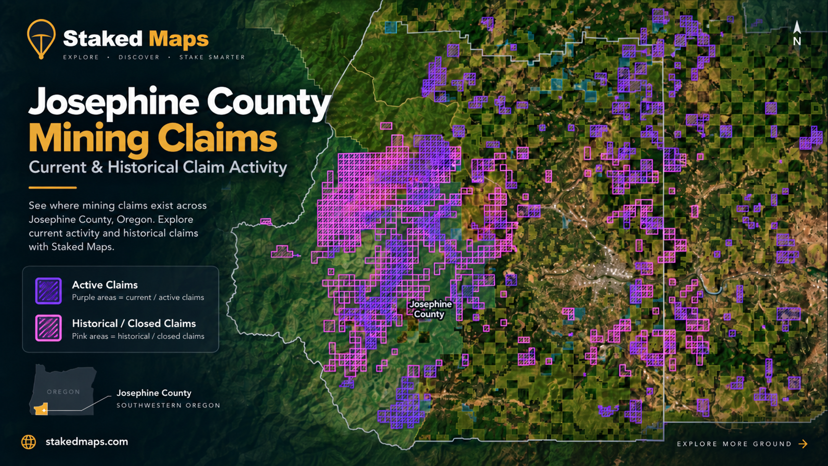
Southwestern Oregon runs along the heavily accreted Klamath Mountains terrane, where ancient oceanic crust produced placer gold along the Rogue, Illinois and Applegate River drainages. Josephine County ranks among Oregon's most heavily claimed counties and remains the center of current claim activity in southwestern Oregon, reflecting the alluvial gravels first worked at Josephine Creek and Jacksonville in 1851. Jackson and Douglas Counties round out the region, the latter mostly placer ground. Grave Creek, Cow Creek and the Illinois River remain the best-documented placer drainages. Lode mining is present but secondary here compared to the placer gravels; the area's mineral wealth is tied more to the Klamath terrane's structure than to a single hard-rock belt. See the county table above for exact current record counts.
Blue Mountains & Eastern Oregon
Northeastern and far-eastern Oregon hold Oregon's largest concentration of current claims by a wide margin. Malheur County alone accounts for the largest share of any Oregon county, with more lode and more placer claims than anywhere else in the state (the Grassy Mountain project, discussed above, is one driver of that concentration). Baker County covers the historic Blue Mountains gold belt, where an 1861 strike at Griffin Gulch built mining camps like Auburn, Sumpter and Canyon City on Jurassic granitic batholiths that intruded gold-bearing quartz veins into the Elkhorn and Greenhorn ranges. Grant County adds further recorded activity around the same belt. Together, these three counties hold well over half of Oregon's current claim records; see the county table above for exact figures.
Western Cascades: The Bohemia Mining District
A third historic district sits in the Western Cascades roughly 25 miles southeast of Cottage Grove, in Lane County. Placer gold turned up on Sharps Creek in 1858, but the strike that built the district came in 1863, when James Henry Sharp's find drew hundreds of prospectors through 1864 and 1865. The Champion, Helena, Musick, and Noonday mines consolidated under the Calapooya Mining and Tunnel Company in 1902, and Bohemia's output at the time helped fund the founding of Cottage Grove itself. The district sits at roughly 5,840 feet and closes under snow through the winter; pavement ends on Forest Service Road 22 and Sharps Creek Road well before Bohemia Saddle, with the final approach turning to gravel and dirt.
Oregon Coast: Beach Placer Gold
Oregon's coastline had its own gold rush, distinct from the interior belts. Fine gold turned up in black beach sands at Whiskey Run, about ten miles north of Bandon in Coos County, in the winter of 1852-1853; by 1854 hundreds of miners were working the sands and the boomtown of Randolph had sprung up along the shore. A single winter storm in 1855 stripped the beach clean and ended the rush almost as fast as it began, though color still shows up today in black-sand stringers along the coast and in the Sixes River drainage in neighboring Curry County, the source that fed gold onto those beaches in the first place.
Terrain, Elevation & Seasonal Access
Access varies sharply by elevation and season. Southwestern Oregon's river-bottom placer ground sits at low elevation along the Rogue, Illinois, and Applegate drainages and can remain accessible for longer stretches of the year, while the higher lode country of the Blue Mountains and the roughly 5,840-foot Bohemia Mining District close under snow through the winter months. Forest Service roads reach much of the public-domain ground in both regions, though the final approach to higher districts like Bohemia turns to gravel or dirt, and some stream-adjacent claims require a walk in from the nearest pullout. Whiskey Run Beach is reached via Seven Devils Road to a small paved parking area, though the beach access road itself is steep, rocky, and can be muddy enough to call for a high-clearance vehicle. Check current BLM, Forest Service and county road conditions before relying on backcountry routes; snow, wildfire, washouts, gates and seasonal closures can all affect access without notice.
Historical & Geological Sources
The historical accounts above draw on DOGAMI's own mining archives. For deeper research on a specific district:
Oregon Rockhounding & Recorded Mineral Occurrences
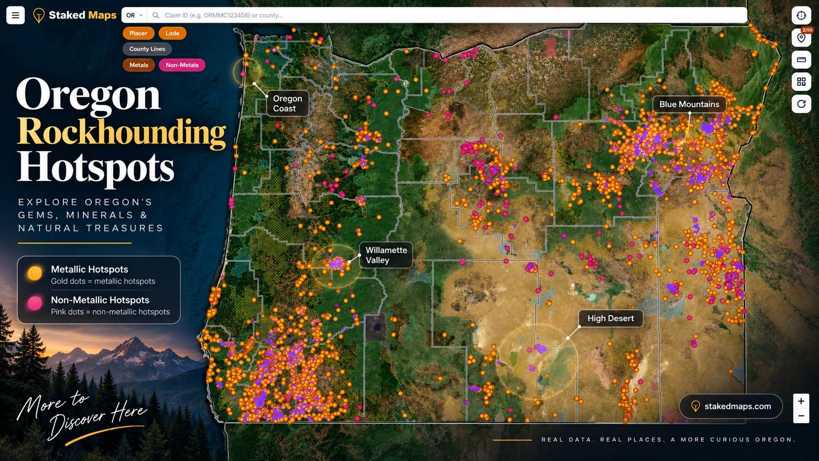
Staked Maps' Rockhound Hotspots layer for Oregon draws from the Oregon Department of Geology and Mineral Industries' Mineral Information Layer for Oregon (MILO-4), the state's own geospatial database of mineral occurrences, prospects and mines, rather than the USGS Mineral Resources Data System (MRDS) that most other states' Rockhound layers use. DOGAMI's current MILO-4 dataset contains 24,664 documented mineral occurrences, prospects and mines statewide. Staked Maps' 9,701 Oregon Rockhound Hotspots are derived from that dataset after filtering bulk and industrial materials that are less relevant to recreational mineral research. A recorded mineral occurrence is not automatically a public collecting site, an access guarantee, or proof of current mineral availability. It documents that DOGAMI has a record of material found at that location.
Why Oregon's Mineral Layer Is Different
Unlike Staked Maps' nationwide mineral-occurrence layer, Oregon uses DOGAMI's state-specific MILO-4 database because it provides richer Oregon mining and mineral information than the national dataset alone.
Staked Maps Oregon Rockhound Hotspots. Gold markers represent metallic mineral records; pink markers represent non-metallic mineral records derived from DOGAMI MILO-4. Locations document recorded mineral occurrences and do not by themselves establish public collecting access.
Oregon Sunstone
The Oregon Sunstone Public Collection Area in Lake County is managed by the Bureau of Land Management for noncommercial sunstone collecting. BLM currently charges no collecting fee, but sunstones collected there may not be collected for trade or commercial purposes. Private mining claims surround the public collection area and also occur within it, making accurate location awareness especially important. Before collecting, use the current BLM map and boundary markers to confirm you're inside the public collection area and not on a private claim. Sunstone, a calcium-rich feldspar gem that formed in basalt lava flows roughly 13 to 14 million years ago, was named Oregon's official state gemstone by the 1987 Oregon Legislature.
Historic Oregon Mining Districts Referenced on This Page
Oregon's mining history spans nearly the entire state, from the coastline to the high desert. The table below summarizes the historic districts named above.
Region
District
County
Era
Primary Commodity
Southwestern Oregon
Josephine Creek / Jacksonville
Josephine
1851
Placer gold
Blue Mountains & Eastern Oregon
Griffin Gulch / Blue Mountains
Baker
1861
Lode and placer gold
Western Cascades
Bohemia Mining District
Lane
1858-1902
Gold, silver, copper
Oregon Coast
Whiskey Run
Coos
1852-1855
Placer gold (black sand)
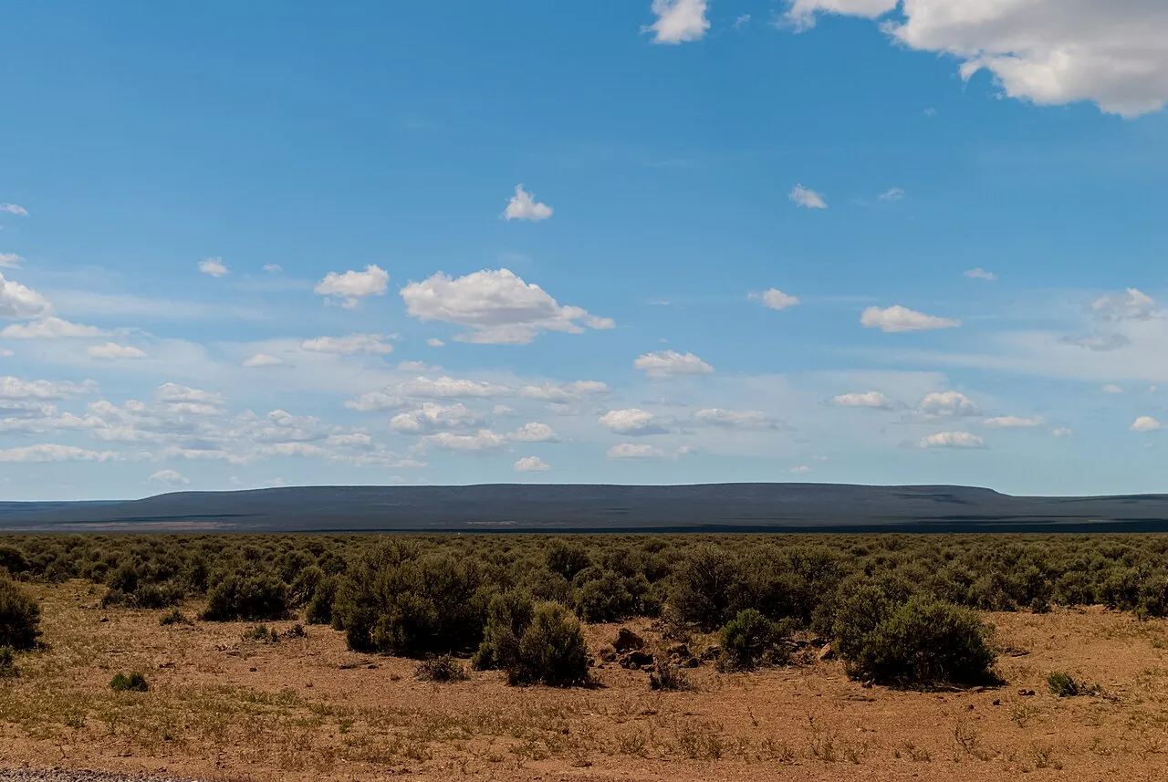
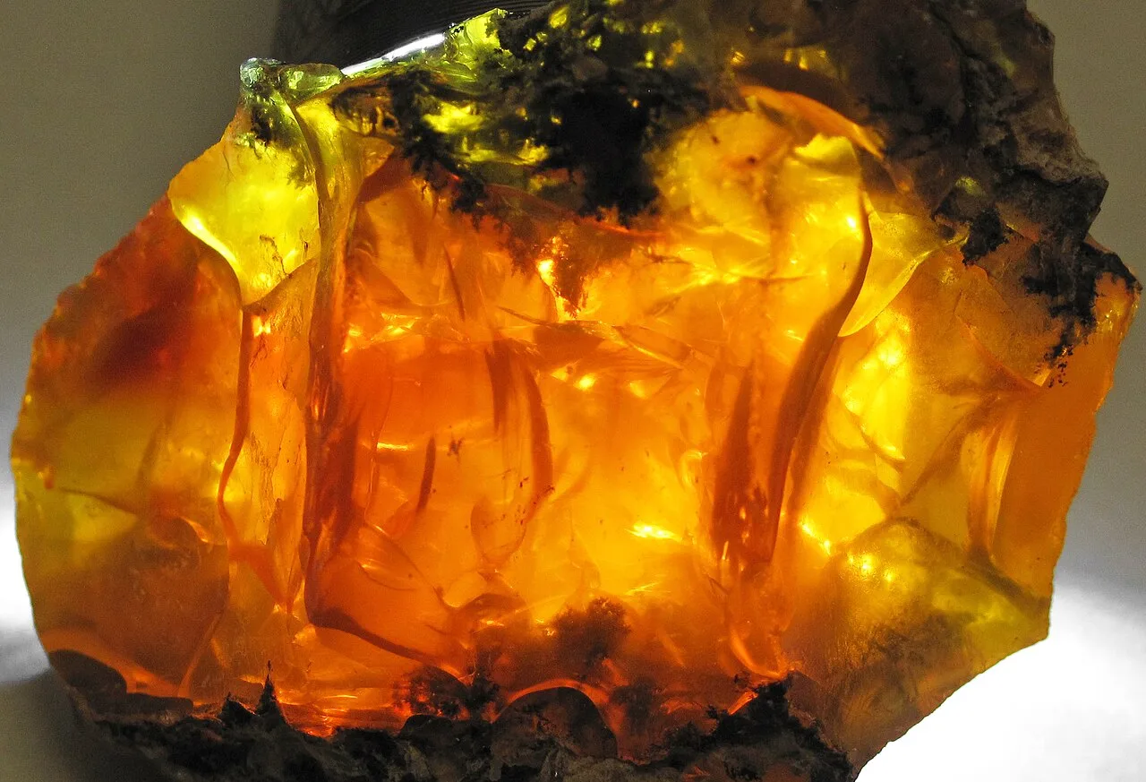
Sunstone mining quarry, Lake County, Oregon. Photo by Shadowmeld Photography, CC BY-SA 4.0, resized for web, via Wikimedia Commons.Fire opal in matrix, Juniper Ridge, Lake County, Oregon. Photo by James St. John, CC BY 2.0, resized for web, via Wikimedia Commons.
Before You Prospect or Mine in Oregon
Mining and prospecting rules in Oregon depend on the land manager, mineral estate, location and equipment being used. Recreational hand panning does not require Oregon DEQ permit coverage; it's the one form of recreational prospecting that's exempt. Other in-stream equipment is treated differently.
Oregon DEQ's current 700-PM general permit regulates motorized suction dredges, gravity/siphon suction dredges, and certain non-motorized in-stream equipment like hand sluices, rocker boxes and hand-suction devices. Motorized and gravity/siphon dredges need to register through Oregon DEQ's online system; non-motorized equipment doesn't need registration but must carry a copy of the permit and follow its conditions. Suction dredging is limited to daylight hours and to the in-water work season set by the Oregon Department of Fish and Wildlife, with hose-size and stream-distance restrictions that vary by location.
Additional requirements may involve the Bureau of Land Management, U.S. Forest Service, Oregon Department of State Lands, Oregon Department of Fish and Wildlife, DOGAMI, local government or other agencies depending on the location and activity.
Do not assume that an active mining claim, public surface ownership, or the absence of a mapped claim determines what equipment you may legally use.
Oregon Rockhounding Material Breakdown
9,110
Metallic Sites
591
Non-Metallic Sites
Notable finds:
Jasper · Agate · Thunderegg · Picture rock or petrified wood (DOGAMI category) · Obsidian · Petrified Wood
Source records sometimes use broad or overlapping commodity labels; counts above preserve the underlying record classifications.
What it is: The official Bureau of Land Management Mineral & Land Records System (MLRS) online portal.
Use case: Researching official federal claim serial numbers, verifying recorded claim holders, and submitting maintenance fees or annual filings online.
What it is: Oregon's own statewide geospatial database of mineral occurrences, prospects and mines, and the source behind Staked Maps' Oregon Rockhound Hotspots.
Use case: Researching recorded mineral occurrences, historical mining records and published geology for a specific Oregon area.
What it is: Oregon DEQ's official water-quality permitting page for metal mining and in-stream mining equipment.
Use case: Current 700-PM permit requirements, fees and registration for suction dredges and other in-stream mining equipment.
How to Research a Prospecting Area in Oregon Before You Go
Check current claims and filings. Start with the current claim layer to see whether current federal mining claim records are mapped in or around your target area.
Check land ownership. Turn on land-ownership boundaries. Public surface ownership does not automatically mean the mineral estate is open to claim location.
Research historical activity. Compare historical claims and recorded mineral occurrences to understand where mining or mineralization has previously been documented.
Verify official land status. Confirm current claim status, mineral entry, withdrawals and restrictions through BLM MLRS and the agency managing the land.
Check activity-specific rules. Before digging, dredging, highbanking or using other equipment, check the current state and federal requirements that apply to that location and method.
Free account · No credit card required · Opens directly to the Oregon map
How Do You View Oregon BLM Mining Claims Offline?
Save any map area while you have cell service, then navigate active BLM mining claims, surface-management boundaries, and optional layers like elevation contours, roads, and creeks — with zero connectivity out in the field. Offline downloads are included on every paid plan. See plans below →
What Premium Adds to Your Oregon Map
Historical Claims. See where mining activity existed before today's current records.
Full Claim Details. Serial number, legal location and a direct BLM record link.
Research Layers. PLSS, roads/trails, waterways and Oregon mineral occurrences.
Offline Maps. Save your Oregon research before losing cell service.
Field Tools. Directions, custom pins, measurements and claim-drafting tools.
Single State unlocks all premium features for Oregon for $29.99/year.
Plans
Choose Your Plan
Basic
Free
Try Staked Maps in one state.
$0/mo
✓Interactive mining claims map — pick your state (or use your location)
✓Surface management overlays & current mining claims
✓Claim type, name, status & size in claim popups
Paid plans unlock full claim details, historical claims, research layers and offline tools.
Single State, Tri-State and All-West all unlock the exact same features — nothing is pay-gated between them, they differ only in how many states you get.
Paid plans renew automatically at the monthly or annual rate you choose until you cancel. Cancel anytime and keep access through the end of your paid period. See our Terms of Use.
Single State, Tri-State and All-West unlock the identical feature set — only the number of states differs.
National Rockhound Pass is a separate, nationwide-but-lighter product built for rockhounds outside the core mining states.
Free
Single State
Tri-State
All-West
Rockhound Pass
Geographic coverage
1 state (view only)
1 state, full data
3 states, full data
13 Western states, full data
All 50 states, safety layer only
Interactive claims map, basemaps, compass, county search
✓
✓
✓
✓
✓
Surface management (public/private land) overlay
✓
✓
✓
✓
✓
Claim type, name, status & size in popups
✓
✓
✓
✓
✓
Full legal location (aliquot description)
✕
✓
✓
✓
✕
Claim serial number, owner intel, BLM Records & 'Directions' button
✕
✓
✓
✓
✕
Search by claim number
✕
✓
✓
✓
✕
Custom pins & distance measure tool
✕
✓ (up to 50)
✓ (up to 50)
✓ (up to 50)
✓
Expired & historical claims layer
✕
✓
✓
✓
✕
Placer/Lode claim filters & latest synchronized data
How Staked Maps Builds the Oregon Mining Claims Map
Staked Maps processes publicly available Bureau of Land Management claim records and synchronizes them into a map optimized for field research. It isn't a substitute for the official record.
Current/not-closed records: BLM MLRS claim and site records currently on file in Staked Maps' database that our reconciliation process hasn't identified as closed. Reconciliation catches claims that drop out of BLM's own active feed and runs on a regular schedule, so a very recently closed claim can briefly still appear active until the next pass.
Historical claims: Records from BLM MLRS's own Closed Mining Claims layer: claims BLM itself reports as closed or expired. This isn't a blend with the legacy LR2000 system BLM retired in 2021; MLRS is the only source. Historical claims use BLM's full Closed Mining Claims dataset (the service's entire multi-decade closed-claims history), not a separate BLM feed limited to recently updated closed cases — this is why Staked Maps' historical total can differ substantially from a site using that kind of recent-change feed.
Sync schedule: Active claim records sync nightly, with a full reconciliation sweep weekly; the historical (closed-claims) figure is revalidated on a monthly schedule.
Claim geometry: Claim boundaries are mapped representations derived from BLM's own legal/PLSS location data, not independently re-surveyed by Staked Maps. Treat them as accurate to BLM's source data, not as survey-grade boundaries in the field.
Rockhound / mineral data: Sourced from DOGAMI MILO-4. Oregon's Rockhound Hotspots come from DOGAMI's own state geological survey database, not the USGS MRDS dataset most other states' Rockhound layers cite.
Limitations: Figures reflect Staked Maps' own processing of public BLM and DOGAMI records, not a live feed. Always verify current status directly with the responsible agency before making a filing or access decision.
Frequently Asked Questions
Where does Staked Maps get its mining claim data?
Directly from the Bureau of Land Management's official MLRS (Mineral & Land Records System) case-recordation records, synced into our database on a regular schedule — not scraped or crowd-sourced.
What's the difference between active and historical claims?
Staked Maps displays the status reported by BLM. Records with a case disposition of Active are labeled Active; historical records come from BLM's closed-claims dataset. These statuses are research information, not a Staked Maps legal determination of claim validity, discovery, ownership or compliance. Verify the current record through MLRS before acting on it.
Can I search by claim number?
Free users can search by county. Paid plans add search by claim serial number, plus each claim's full legal (aliquot) description and BLM records link.
How many active mining claims are in Oregon?
As of September 22, 2026, BLM records in Staked Maps show 8,722 Oregon mining claim and site records with a case disposition of Active. Another 33 are Under Review, 2,572 are Filed and 1 is Pending, bringing Oregon's total current/not-closed federal claim and site records to 11,328. These database statuses are not a legal determination that an individual claim contains a valid mineral discovery.
What are Rockhound Hotspots?
A premium map layer of documented mineral occurrences, prospects and mines sourced from DOGAMI MILO-4 and labeled by material where available. These records are research leads, not a directory of verified public collecting sites.
Where are most mining claims in Oregon?
Oregon's current federal mining-claim records are concentrated in a handful of counties. As of the data date above, Malheur County ranks first, followed by Baker County and Josephine County. Together, those counties account for about 73% of Oregon's current mapped claim/site records. Claim concentration indicates recorded mining activity, not whether adjacent land is open for prospecting or whether it has mineral potential.
Does the Oregon map cover the whole state?
Yes. Staked Maps covers Oregon statewide. Dedicated research pages are currently available for Baker County, Grant County, Jackson County and Josephine County, while the interactive map covers claims and surface management throughout Oregon.
Which agency manages federal mining claims in Oregon?
The Bureau of Land Management Oregon/Washington State Office administers federal mining-claim records for Oregon. MLRS is BLM’s official online system for researching claims, filing certain documents and paying applicable fees. County recording requirements also apply when locating a new claim.
Does land without an active claim mean I can prospect there?
No. The absence of a mapped active mining claim only tells you that Staked Maps isn't showing an active claim record at that location from the applicable source data. The land may still be private, withdrawn from mineral entry, subject to split mineral ownership, restricted by a special designation, or governed by other rules. Treat an apparent gap as a place to begin land-status research, not proof that the ground is open.
Can I prospect on someone else's mining claim?
Do not prospect for or remove locatable minerals from someone else's valid mining claim without permission from the claimant. Public surface access and mineral rights are separate issues, and access rules can vary by location. Use the map to identify possible claims, then verify the official record before conducting mineral exploration.
Do I need a permit to pan for gold in Oregon?
Simple recreational gold panning by hand doesn't require Oregon DEQ permit coverage; it's exempt. Suction dredges and certain other in-stream equipment fall under Oregon's current 700-PM permit framework, with registration, season and location rules that vary. Always check the current requirements for the specific waterway and method before you start.
Information hosted on Staked Maps is compiled from publicly available data
streams provided by the Bureau of Land Management (BLM) and relevant state
geographic clearinghouses. Staked Maps accepts no liability for the content of
this geospatial data, or for the consequences of any real-world exploration,
land entry, or staking actions taken on the basis of the information provided
via this application interface.
Staked Maps makes no warranty, expressed or implied, including the warranties of
merchantability and fitness for a particular purpose, nor assumes any legal
liability or responsibility for the pinpoint accuracy, reliability, completeness,
latency, or programmatic utility of these geospatial data layers, or for the
improper interpretation of these data grids.
These mapping layers and related graphics are visual convenience aids only; they
are not legal documents and must never be used as such. The data may not be used
to legally determine title, mineral ownership, valid description boundaries,
jurisdictional authorities, or land restrictions in place on public or private
land. Natural backcountry hazards may or may not be depicted on topographies, and
land users are strictly mandated to exercise caution. Federal records are dynamic
and change constantly. The end-user is exclusively responsible for validating
current land classifications with local BLM field offices and managing compliance
accordingly.