Alaska Mining Claims Map: Federal BLM & State DNR Claims
Alaska is the one state where researching a prospecting location means checking two separate claim systems. The Bureau of Land Management administers federal mining claims on eligible public land, while the Alaska Department of Natural Resources administers mineral-property rights — including mining claims — on state land. Staked Maps already combines both into one Alaska map, so you're not cross-referencing two different agency websites before you head out.
As of September 22, 2026, Staked Maps shows 49,752 current federal and state claim records and 199,386 historical records for Alaska, plus 11,063 documented mineral-occurrence records. A gap between mapped claims isn't by itself proof that a spot is open to stake or prospect — land status, access and authorization still have to be checked separately, covered further down this page.
Free account · No credit card required · Opens directly to the Alaska map
Alaska Mining Claims at a Glance
49,752
Current Alaska Claim & Site Records
199,386
Historical Claim Records
11,063
Documented Mineral Occurrences
Mining claim data synchronized: . Federal BLM and Alaska DNR claim records synchronize on a regular schedule, not live with every visit.
Alaska Has Two Mining-Claim Systems to Research
If you're planning to prospect in Alaska, there's one thing to sort out before anything else: is the ground you're interested in under federal jurisdiction, state jurisdiction, or something else entirely? The Bureau of Land Management (BLM) administers federal unpatented mining claims on eligible federal public land. The Alaska Department of Natural Resources (DNR), through its Mineral Property Management section, administers mineral-property rights on state land — including state mining claims, leasehold locations and prospecting sites. These are two separate legal systems with two separate sets of records, and Staked Maps brings both onto a single map.
They aren't interchangeable, and a claim in one system tells you nothing about the other. A blank spot on the federal layer over land that's actually state-owned isn't “unclaimed” — it just means you're looking at the wrong dataset. Checking both is the first real step in researching any Alaska location, not an optional extra.
Source
Current Records
Historical Records
BLM federal
9,517
119,894
Alaska DNR state
40,235
79,492
Combined
49,752
199,386
Combined statewide totals include both federal and state records. Detailed claim-type and status charts further down this page use BLM federal data only, because Alaska DNR records don't use the same classification system — forcing them into BLM's categories would create a comparison that looks tidy but isn't accurate. More on that distinction below.
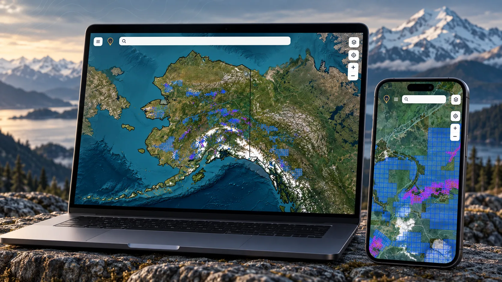
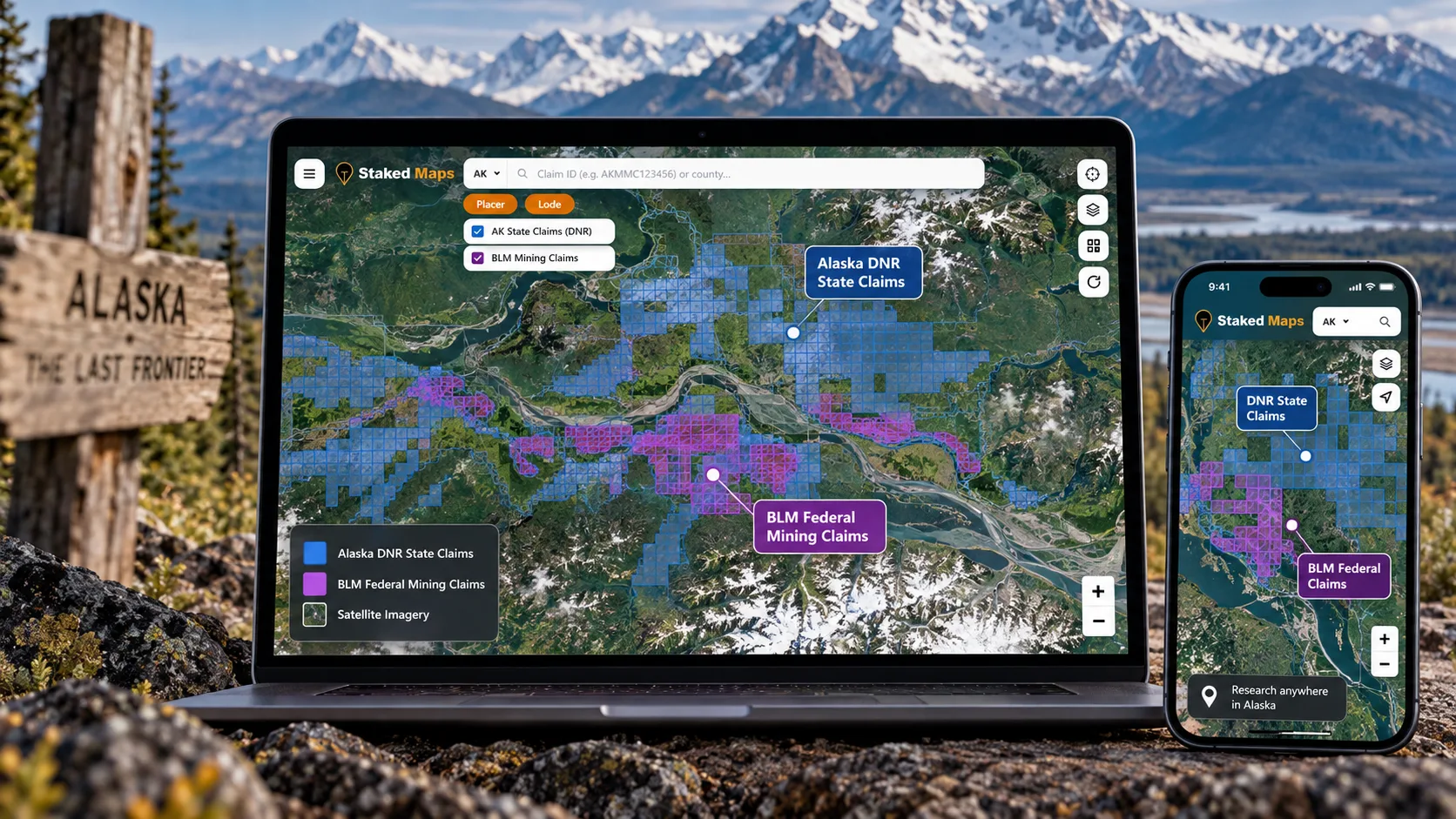
Federal BLM mining claims and Alaska DNR state claims shown together on the Staked Maps Alaska map.
Explore Alaska Claims on the Map
Reading the numbers above is a start. Seeing where those claims actually sit relative to the ground you're interested in is what makes the research usable.
See both systems at once. View current BLM federal claims and Alaska DNR state claims on the same map instead of checking two separate agency sites.
Layer in historical activity. Add closed and historical claim records to understand what's been worked before.
Take it with you. Paid plans add offline map downloads, built for the parts of Alaska where you won't have cell service.
Free account · No credit card required · Opens directly to Alaska
Looking for Abandoned Gold Claims in Alaska? Start With Historical Claims
People searching for “abandoned gold claims in Alaska” are usually looking for one of a few things: closed claims, historical mining activity, previously claimed ground, or areas with a documented history of mining. Neither BLM nor Alaska DNR uses “abandoned” as an official status — BLM's federal records use a closed/historical designation, and Alaska DNR's state records track active and closed status separately.
A historical or closed mining claim is a research lead. It doesn't, on its own, establish that the land is currently available for mineral entry, accessible to the public, or legally open for prospecting or staking. A closed claim tells you someone worked that ground before, which can be useful context. It doesn't tell you the current land status, who currently holds any mineral rights there, or whether the surface is even reachable.
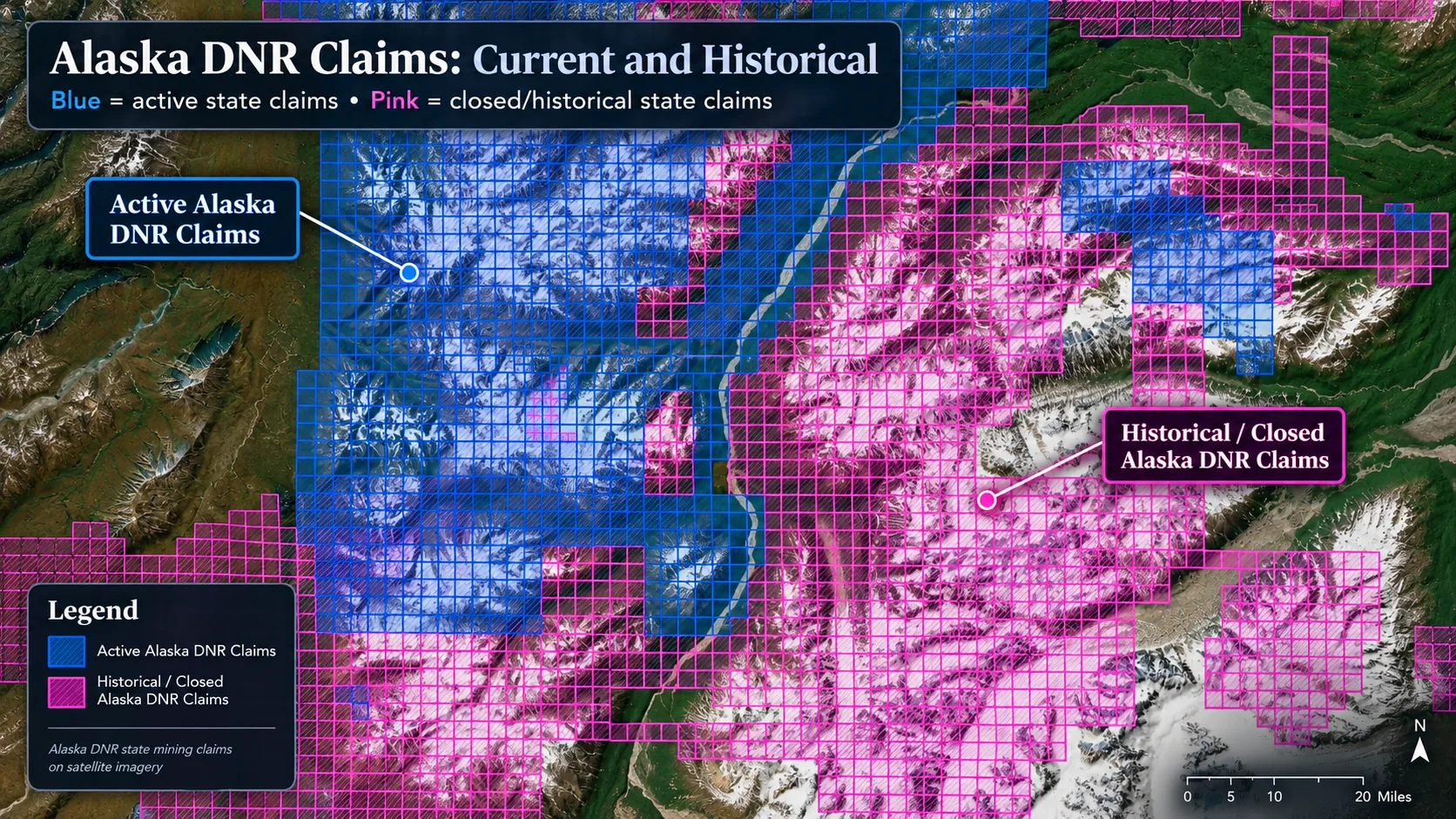
Active (blue) and historical/closed (pink) Alaska DNR state claims. This view shows Alaska DNR's own active/closed records; BLM's federal closed-claims layer is a separate dataset, and both are included in the combined historical total above.
Staked Maps currently shows 199,386 historical claim records for Alaska, combining BLM's closed federal claims with Alaska DNR's closed state claims. If a location interests you because of its history, treat that as a starting point for further research — checking current land status, ownership and access — not as an answer by itself.
Current Federal Mining Claims in Alaska by Claim Type
7,446
Lode Claims
1,845
Placer Claims
223
Mill Site Claims
3
Tunnel Site Claims
Lode and placer records describe different forms of mineral location; mill sites and tunnel sites are separate location types under the Mining Law, not a third mineral-claim category. The mix is useful for understanding the character of recorded activity, but it doesn't determine whether surrounding land is open to new claim location.
Reflects BLM federal claims only — Alaska DNR's state mining-claim records aren't classified by claim type the same way.
Alaska Claims by Type, Visualized
Claim Type
Current Claims
Lode Claims
7,446 (78.2%)
Placer Claims
1,845 (19.4%)
Mill Site Claims
223 (2.3%)
Tunnel Site Claims
3 (<0.1%)
BLM Federal Claim Status in Alaska
Alaska DNR's state mining claims use their own status vocabulary and aren't included in this breakdown — see the two-system comparison above for how they fit into Alaska's combined totals. Here's the current BLM federal claim/site breakdown by case disposition:
BLM Status
Records
Active
8,715
Filed
683
Under Review
119
Filed and Under Review records have a pending BLM case action and shouldn't be treated as identical to a fully Active claim. Verify a specific claim's exact status through BLM MLRS, or an Alaska DNR state claim's status directly with Alaska DNR, before relying on it.
See where Alaska's current claim records are located
Open the free Alaska map to inspect recorded claims alongside surface-management boundaries.
Where Are Current Alaska Mining Claims Concentrated?
Alaska's boroughs and census areas — not counties, which Alaska doesn't have — combining current BLM federal and Alaska DNR state records for each.
Borough / Census Area
BLM
Alaska DNR
Combined
% of Alaska Total
Yukon-Koyukuk Census Area
990
9,607
10,597
21.3%
Southeast Fairbanks Census Area
159
7,140
7,299
14.7%
Fairbanks North Star Borough
153
5,339
5,492
11.0%
Matanuska-Susitna Borough
426
4,532
4,958
10.0%
Northwest Arctic Borough
0
3,783
3,783
7.6%
1,238 current BLM record(s) and 51 current Alaska DNR record(s) statewide couldn't be matched to a borough/census area (mostly records missing usable geometry) and aren't included in the rows above, so the percentages don't sum to exactly 100%.
Research Yukon-Koyukuk Census Area, Southeast Fairbanks Census Area and Fairbanks North Star Borough on the map
Move from statewide totals to the claim locations and land context for the area you are researching.
Why Empty Space Between Alaska Claims Does Not Mean the Land Is Open
Alaska is enormous, and most of it has no mapped mining claim at all. That's easy to misread as “open ground.” In practice, whether you can research, prospect or stake a specific spot in Alaska depends on land status and mineral ownership, not just the absence of a nearby claim. Four categories cover most of what you'll run into:
Federal land. The absence of a current claim doesn't by itself establish that the federal mineral estate at that location is open to location. Mineral withdrawals, acquired lands and other restrictions can apply even where no claim is currently on file.
Alaska state land. State land has its own mineral-entry system, run by Alaska DNR, separate from the federal process. State-owned ground isn't automatically open just because it isn't federal.
Withdrawn land. Alaska has an unusually complex withdrawal history. BLM notes that Alaska's remaining d-1 withdrawals, dating to the ANCSA era, continue to affect the status of public land in the state and can restrict activity like mining claims until BLM's land-use planning process completes and a specific withdrawal is revoked.
Native corporation and private land. Alaska Native corporation land is private land, not public land. Some tracts carry reserved public easements, including certain ANCSA 17(b) easements, but the easement itself doesn't make the surrounding land public. Alaska DNR is explicit that departing an applicable 17(b) easement onto Native land without the landowner's express permission is trespass.
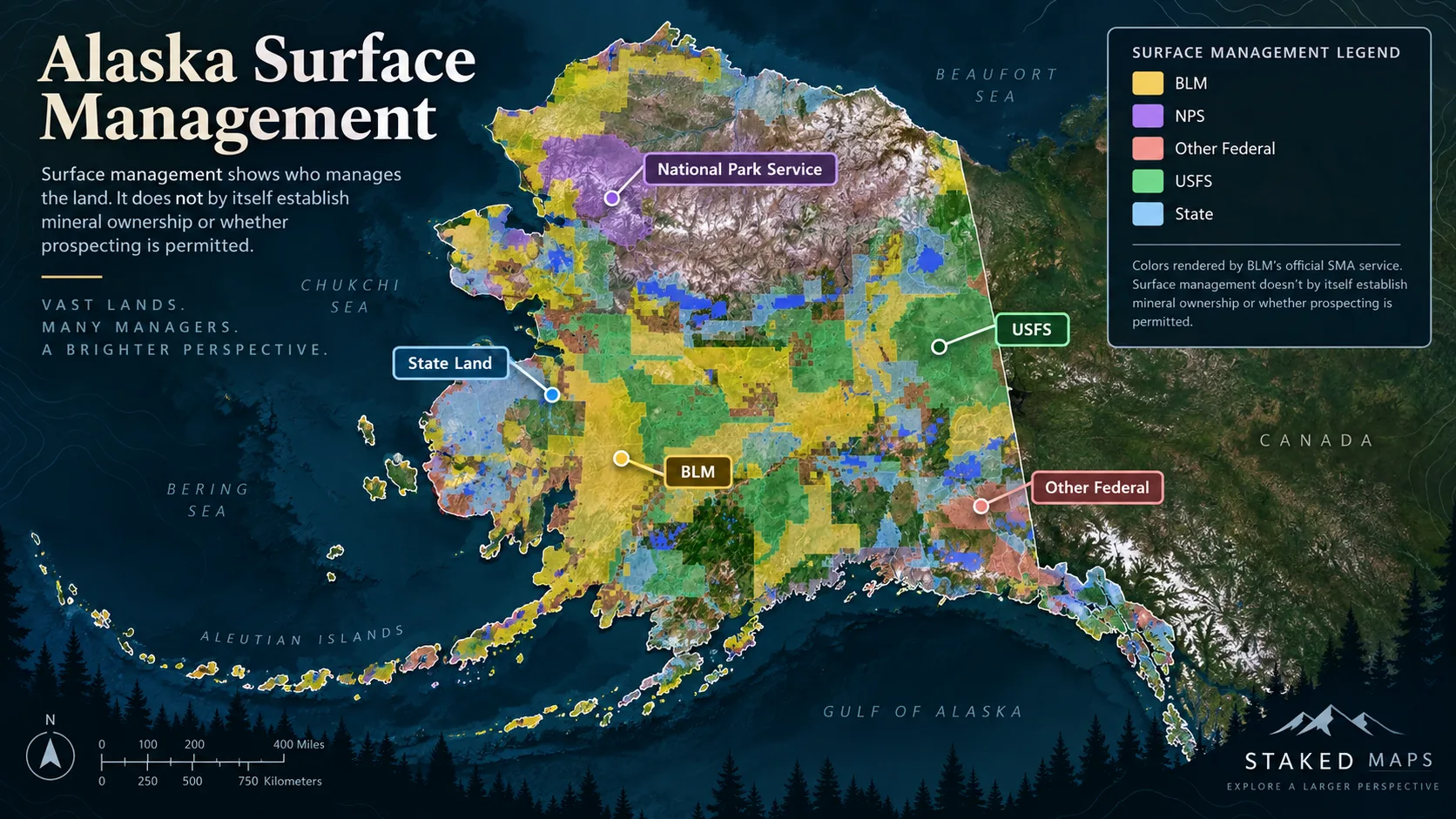
Alaska surface management by managing agency (BLM, NPS, other federal, USFS and State). Surface management alone doesn't establish mineral ownership or whether prospecting is permitted — private and Native corporation land isn't broken out as its own category on this layer, and needs to be checked separately.
Legal Access and Physical Access Are Not the Same Thing in Alaska
Even once you've sorted out land status, getting there is its own question. Legal access — the right to be somewhere — doesn't guarantee physical access, like a maintained road or trail. Alaska DNR is explicit that legal access doesn't necessarily mean practical or constructed access exists. An easement can come with its own use restrictions, and crossing private or Native corporation land without permission is trespass regardless of what the map shows nearby.
This is also where Alaska's remoteness makes offline research genuinely useful rather than a nice-to-have: once you're out of cell service, you can't pull up a claim boundary or a land-status layer to double-check anything. Save the area before you leave service, not after.
Save any map area while you have cell service, then navigate current and historical BLM federal claims, Alaska DNR state claims, surface-management boundaries, and optional layers like elevation contours, roads, and creeks — with zero connectivity out in the field. Offline downloads are included on every paid plan. See plans below →
How Alaska State Mining Claims Differ From Federal Claims
Alaska DNR's state mineral-property system isn't a state-run copy of the federal claim process — it works differently in several concrete ways worth knowing before you assume a state claim behaves like a federal one.
State mineral-property rights are their own legal framework. They're established and maintained under Alaska state law, administered by Alaska DNR's Mineral Property Management section, not under the federal General Mining Law BLM administers.
Mining claims are one of several location types. Alaska DNR's state system also includes leasehold locations and prospecting sites — distinct mineral-property mechanisms, not variations on the same instrument. Don't assume every record in Alaska's state claims data is legally identical.
Location descriptions and claim sizes differ. State claims commonly use MTRSC (Meridian, Township, Range, Section, Cell) location descriptions, and depending on the location form, an Alaska state mining claim can run roughly 40 or 160 acres.
Discovery is still required. As with a federal claim, a valid Alaska state mining claim requires an actual mineral discovery — staking ground alone doesn't establish a valid claim in either system.
Because of these differences, Staked Maps doesn't force Alaska DNR's records into BLM's claim-type categories (lode, placer, mill site, tunnel site) — see the claim-type and status sections above. If you need an authoritative answer about a specific state claim, Alaska DNR's Mineral Property Management section is the office to contact, not BLM.
Having a Claim Does Not Automatically Authorize Mining
A mapped claim — federal or state — establishes a possessory interest, not a blanket permit to mine however you want. Whether an activity requires separate authorization comes down to scale and disturbance, not just claim status.
For an individual prospector, the practical line usually runs between casual, low-impact activity and anything mechanized or larger in scale. On BLM land, hand tools and similar minimal-disturbance activity are generally treated as casual use; motorized equipment, larger-scale earth-moving or sustained operations usually cross into activity that needs authorization. On state land, Alaska DNR's own guidance distinguishes simple recreational activity — hand panning is the clearest example — from operations that exceed its Generally Allowed Uses guidelines and require a permit. Alaska's APMA (Application for Permits to Mine in Alaska) process is the mechanism that coordinates the exploration and mining authorizations larger activity needs, sometimes across multiple state and federal agencies at once.
Can you mine anywhere you find an Alaska claim?
No. Claim status, land ownership, access and authorization to conduct mining activity are separate questions. A valid claim doesn't answer any of the other three.
This is informational, not legal advice — the specific activity you're planning, its scale, and the exact land status of the location all affect what's required. Verify directly with BLM or Alaska DNR, depending on which system covers the ground, before you start.
Documented Mineral Occurrences Across Alaska
Beyond claims, Staked Maps includes 11,063 documented mineral-occurrence records for Alaska, drawn from the USGS Mineral Resources Data System (MRDS). These records describe documented occurrences, prospects and mines — some are historic mine sites, some are single reported occurrences, and which label a record carries depends on what USGS's source data actually recorded there.
Treat these as research leads for further investigation, not a directory of open collecting sites. A documented occurrence means USGS has a record of material found at that location at some point — it says nothing about current land status, mineral ownership, or whether the location is open to public collecting today. Check land status and access separately, the same as you would for a claim.
Staked Maps splits Alaska's records into two broad groups below — metallic and non-metallic — and only calls out an individual material by name once it occurs often enough in the data to be a genuinely notable find, not a single-digit outlier dressed up as a ranking. If no individual material clears that bar, use the interactive Rockhound Hotspots map layer to filter and inspect records for a specific area instead.
Alaska Mineral Occurrence Records by Type
11,008
Metallic Sites
55
Non-Metallic Sites
Explore Alaska Mining Regions in More Detail
Alaska's mining and mineral activity isn't spread evenly across the state. These five areas have enough recorded activity and history to be worth their own dedicated research pages:
Fairbanks & Circle District — Alaska's largest historic gold-mining region by cumulative production, still home to significant current claim activity.
Nome & Seward Peninsula — historic beach and offshore placer gold country, with a mining history distinct from Alaska's interior districts.
Fortymile River & Chicken — one of Alaska's earliest gold-rush districts, still an active recreational and small-scale mining area today.
Mat-Su Valley — closer to Anchorage and more road-accessible than much of the state, with both lode and placer history.
Kenai Peninsula — road-system-accessible mining history on Alaska's southcentral coast.
How to Research an Alaska Prospecting Location Before You Go
Establish land management first. Determine whether you're looking at federal, Alaska state, private/Native corporation, or another land category before anything else.
Check current claim records — both systems. Review BLM federal claims and Alaska DNR state claims for the area; a blank result in one system doesn't cover the other.
Review historical activity. Closed claims and documented mineral occurrences can point toward areas worth a closer look, without answering current status on their own.
Verify with the official record. For federal claim questions, that's BLM. For Alaska state mineral-property questions, that's Alaska DNR. Staked Maps is a research tool, not the system of record for either.
Check access and restrictions. Look into withdrawals, private and Native corporation land, easements, and any other applicable land-management rules for the specific spot.
Match your planned activity to what it actually requires. Hand prospecting, motorized equipment and larger mining operations aren't legally equivalent — confirm what authorization your specific plan needs.
Save the area offline, then go. Once you're outside cell service, you can't look any of this up again — download your research area before you leave.
What it is: The state office administering mineral-property rights on Alaska state land, including mining claims, leasehold locations and prospecting sites.
Use case: Researching state mining claim laws, filing state location certificates, checking state land status, and applying for APMA permits.
What it is: Alaska's state geological survey, providing mineral maps, historical reports and geochemical sampling data.
Use case: Downloading geologic quadrangle maps and reviewing historical mining-district reports.
How Staked Maps Builds the Alaska Mining Claims Map
Staked Maps synchronizes two separate government data sources into one Alaska map: federal Bureau of Land Management claim records and Alaska Department of Natural Resources state claim records. It isn't a substitute for either agency's official record.
Current/not-closed records: For BLM federal records: MLRS claim and site records currently on file in Staked Maps' database that our reconciliation process hasn't identified as closed. For Alaska DNR state records: claims Alaska DNR's own active-claims layer currently reports as active. The combined current total on this page adds both together.
Historical claims: For BLM federal records: BLM MLRS's own Closed Mining Claims layer, covering claims BLM itself reports as closed or expired. For Alaska DNR state records: claims Alaska DNR's own closed-claims layer currently reports as closed. The combined historical total on this page adds both together.
Alaska DNR state claims: Synced from Alaska DNR's own state mining-claim GIS layers (active and closed), covering mineral-property records administered under Alaska state law. This is a separate system from BLM's federal MLRS records, with its own classification and status vocabulary — see the two-system breakdown near the top of this page.
Sync schedule: Both BLM federal and Alaska DNR state claim data sync into Staked Maps on a regular schedule, not live with every visit — check the data-updated date below for the most recent sync.
Claim geometry: The two sources aren't built the same way. Most federal BLM claim boundaries come directly from BLM's own published claim-boundary geometry — BLM describes these as non-surveyed boundaries digitized from casefile sketches, claimant maps and legal descriptions, not a ground survey, but it's BLM's own geometry, not something Staked Maps computes. When BLM's service doesn't return usable geometry for a specific claim, Staked Maps derives a fallback boundary from that claim's own legal/PLSS location data instead, and this is not independently re-surveyed by Staked Maps either way. Alaska DNR state claim boundaries are always ingested directly from Alaska DNR's own published GIS polygon data. Treat all of these as accurate to their source records, not as survey-grade boundaries in the field.
Rockhound / mineral data: Sourced from USGS MRDS. These are documented occurrences, prospects and mines, not a directory of verified public collecting sites.
Limitations: Staked Maps is a research tool, not the official record for either system. For a specific federal claim, verify directly through BLM MLRS. For a specific Alaska state claim, verify directly through Alaska DNR.
What Premium Adds to Your Alaska Map
Historical Claims. See where mining activity existed before today's current records.
Full Claim Details. For federal claims: serial number, legal location and a direct BLM record link. For Alaska DNR state claims: case ID, legal location and a direct AK DNR record link where available.
Research Layers. PLSS, roads/trails, waterways and Alaska mineral occurrences.
Offline Maps. Save your Alaska research before losing cell service.
Field Tools. Directions, custom pins, measurements and claim-drafting tools.
Single State unlocks all premium features for Alaska for $29.99/year.
Plans
Choose Your Plan
Basic
Free
Try Staked Maps in one state.
$0/mo
✓Interactive mining claims map — pick your state (or use your location)
✓Surface management overlays & current mining claims
✓Claim type, name, status & size in claim popups
Paid plans unlock full claim details, historical claims, research layers and offline tools.
Single State, Tri-State and All-West all unlock the exact same features — nothing is pay-gated between them, they differ only in how many states you get.
Paid plans renew automatically at the monthly or annual rate you choose until you cancel. Cancel anytime and keep access through the end of your paid period. See our Terms of Use.
Single State, Tri-State and All-West unlock the identical feature set — only the number of states differs.
National Rockhound Pass is a separate, nationwide-but-lighter product built for rockhounds outside the core mining states.
Free
Single State
Tri-State
All-West
Rockhound Pass
Geographic coverage
1 state (view only)
1 state, full data
3 states, full data
13 Western states, full data
All 50 states, safety layer only
Interactive claims map, basemaps, compass, county search
✓
✓
✓
✓
✓
Surface management (public/private land) overlay
✓
✓
✓
✓
✓
Claim type, name, status & size in popups
✓
✓
✓
✓
✓
Full legal location (aliquot description)
✕
✓
✓
✓
✕
Claim serial number, owner intel, BLM Records & 'Directions' button
✕
✓
✓
✓
✕
Search by claim number
✕
✓
✓
✓
✕
Custom pins & distance measure tool
✕
✓ (up to 50)
✓ (up to 50)
✓ (up to 50)
✓
Expired & historical claims layer
✕
✓
✓
✓
✕
Placer/Lode claim filters & latest synchronized data
How many current mining claim records are in Alaska?
As of September 22, 2026, Staked Maps shows 49,752 combined current Alaska claim and site records: 9,517 current/not-closed federal records (BLM's own case disposition shows 8,715 Active; another 119 are Under Review and 683 are Filed) and 40,235 active records from Alaska DNR state claims. These database statuses are not a legal determination that an individual claim contains a valid mineral discovery.
What are Rockhound Hotspots?
A premium map layer of documented mineral occurrences, prospects and mines sourced from USGS MRDS and labeled by material where available. These records are research leads, not a directory of verified public collecting sites.
Does the Alaska map cover the whole state?
Yes. Staked Maps covers Alaska statewide. Dedicated research pages are currently available for Fairbanks & Circle District, Nome & Seward Peninsula, Fortymile River & Chicken, Mat-Su Valley and Kenai Peninsula, while the interactive map covers claims and surface management throughout Alaska.
Which agency manages federal mining claims in Alaska?
Alaska has two separate systems. Federal mining claims on eligible federal land are administered by the Bureau of Land Management (BLM). Mineral-property rights on Alaska state land — including state mining claims, leasehold locations and prospecting sites — are administered separately by the Alaska Department of Natural Resources (DNR). See the Official Filing & Information Links section above for direct links to both.
Where does Staked Maps get its Alaska mining claim data?
From two sources: the Bureau of Land Management's MLRS records for federal claims, and Alaska DNR's state mining-claim records for state land, synced into our database on a regular schedule. Documented mineral-occurrence records come separately from the USGS Mineral Resources Data System.
What's the difference between current and historical claims in Alaska?
Current records combine BLM federal claims that aren't marked closed with Alaska DNR state claims marked active. Historical records combine BLM's closed federal claims with Alaska DNR's closed state claims. The two agencies track this status independently of each other — see the federal/state breakdown above for the exact split.
Can I search Alaska mining claims by claim number?
Paid plans let you search by claim serial number and open a claim's full record details directly. Alaska doesn't have counties, so free accounts browse and pan the map by region instead.
Does Staked Maps include Alaska state mining claims?
Yes. Unlike most other states, where Staked Maps' claim data is BLM federal records only, Alaska's dataset also incorporates Alaska DNR state mining-claim records.
Are Alaska DNR claims included in the claim-type charts?
No. The claim-type and BLM-status breakdowns on this page describe federal BLM records only, because Alaska DNR records use a different classification system. DNR records are still included in the combined statewide current and historical totals.
Does a closed or abandoned mining claim mean the land is open in Alaska?
No. A closed or historical claim shows past claim activity. It doesn't by itself establish current land ownership, mineral-entry status, access rights, or whether the ground can legally be claimed today.
Can I prospect on a historical Alaska mining claim?
Not automatically. Current land ownership, mineral-entry status, access and applicable land-management rules all need to be checked separately before treating a historical claim area as available.
Are Alaska Native corporation lands public land?
No. Alaska Native corporation lands are private land. Some tracts carry reserved public easements, including certain ANCSA 17(b) easements, but the easement itself doesn't make the surrounding land public — leaving the easement onto Native land without permission is trespass.
Can I use Staked Maps offline in Alaska?
Yes. Download a map area — including claim data and any other layers you've enabled — while you have cell service, then view it in the field with no connection. This is especially useful in Alaska, where large areas have no cell coverage at all.
Start With the Free Alaska Map
Alaska's mining-claim landscape runs on two systems, a complicated land-status history, and country that's remote enough to make offline research genuinely necessary. Staked Maps brings BLM federal claims, Alaska DNR state claims, surface management and mineral-occurrence data into one map so you can do that research before you're standing in the field without service.
Information hosted on Staked Maps is compiled from publicly available data
streams provided by the Bureau of Land Management (BLM) and relevant state
geographic clearinghouses. Staked Maps accepts no liability for the content of
this geospatial data, or for the consequences of any real-world exploration,
land entry, or staking actions taken on the basis of the information provided
via this application interface.
Staked Maps makes no warranty, expressed or implied, including the warranties of
merchantability and fitness for a particular purpose, nor assumes any legal
liability or responsibility for the pinpoint accuracy, reliability, completeness,
latency, or programmatic utility of these geospatial data layers, or for the
improper interpretation of these data grids.
These mapping layers and related graphics are visual convenience aids only; they
are not legal documents and must never be used as such. The data may not be used
to legally determine title, mineral ownership, valid description boundaries,
jurisdictional authorities, or land restrictions in place on public or private
land. Natural backcountry hazards may or may not be depicted on topographies, and
land users are strictly mandated to exercise caution. Federal records are dynamic
and change constantly. The end-user is exclusively responsible for validating
current land classifications with the appropriate BLM office and/or Alaska DNR, depending on the land and claim system involved and managing compliance
accordingly.