South Dakota Mining Claims & Black Hills Land Research
South Dakota Mining Claims Map: Current BLM Claims & Black Hills Land Status
Research current and historical federal mining claim records, surface management, mineral occurrences, and the land-status questions that matter in South Dakota’s Black Hills.
Free account · No credit card required · Opens directly to the South Dakota map
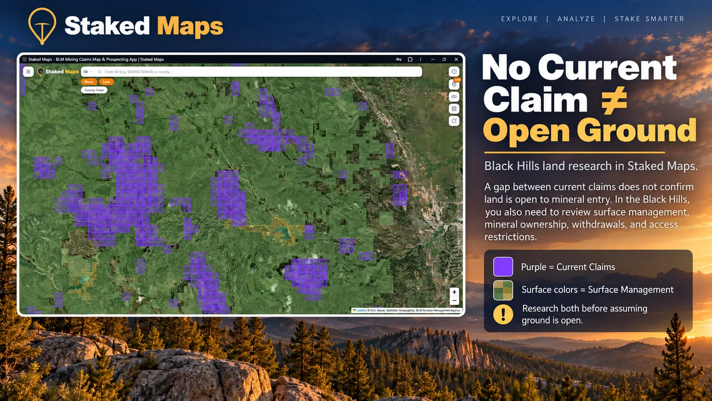
Current claims and surface management shown together for the Black Hills in Staked Maps.
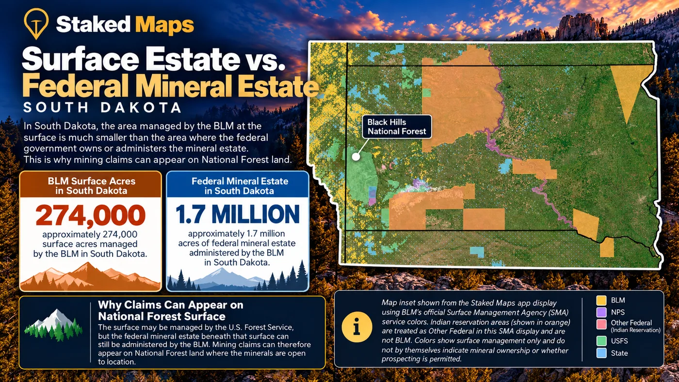
South Dakota’s federal mining claim activity is concentrated heavily in the Black Hills, but a mining claim polygon answers only one part of a land-research question. The BLM South Dakota Field Office manages more than 274,000 surface acres and around 1.7 million acres of subsurface mineral estate in South Dakota. The Forest Service manages much of the surface in the Black Hills, and BLM notes that mining claims can be located on open public land administered by another federal agency, most commonly Forest Service land. That split is one reason a federal mining claim can appear on National Forest surface.
Staked Maps brings current and historical BLM claim records, BLM Surface Management Agency data, PLSS information and mineral-occurrence research into one prospecting-focused map. The layers answer different questions. A mapped claim does not establish surface ownership, and the absence of a current claim does not by itself establish that land is open to mineral entry.
Use the map to identify recorded activity and organize your research, then verify current claim status, mineral-entry status, access restrictions and applicable rules with the responsible government agencies before acting on the information.
What Does the Current South Dakota Mining Claim Data Show?
11,360
Current / Not-Closed Claim & Site Records
10,958
BLM Disposition: Active
226,935
Historical Claim Records
1,601
Documented Mineral-Occurrence Records
“Current / not closed” includes BLM records whose case disposition is not Closed. It should not be read as a legal determination that every record represents a valid mineral discovery.
Mining claim data synchronized: . BLM MLRS records are synchronized with Staked Maps on a regular schedule, not live with every page visit. Mineral-occurrence records are research data derived from USGS MRDS.
Current Does Not Mean the Same Thing as BLM Active
Staked Maps separates the broader group of current/not-closed BLM records from BLM’s individual case-disposition labels. In the current South Dakota snapshot, most not-closed records are labeled Active, but Filed, Under Review and Submitted records are also present.
BLM Status
Records
Share of Current Records
Active
10,958
96.5%
Filed
396
3.5%
Under Review
4
<0.1%
Submitted
2
<0.1%
Total Current / Not-Closed
11,360
100%
These are BLM administrative case-disposition labels. They are not a Staked Maps determination of claim validity, mineral discovery, property ownership or whether nearby land is open to new mineral location. Verify an individual record through BLM MLRS when the distinction matters.
What Types of Current Mining Claims and Sites Are Recorded in South Dakota?
South Dakota’s current federal record set is overwhelmingly lode claims. Placer claims make up a much smaller share, while mill sites and tunnel sites account for only a handful of records.
Record Type
Current Records
Share
Lode claim
10,519
92.6%
Placer claim
828
7.3%
Mill site
12
0.1%
Tunnel site
1
<0.1%
Lode and placer are different forms of mineral location under federal mining law. Mill sites and tunnel sites are separate location types. The presence or absence of any of these records does not by itself determine whether surrounding land is open to mineral entry.
Where Are South Dakota’s Current Mining Claims Concentrated?
Mining claim activity is not distributed evenly across South Dakota. Lawrence County currently ranks first, followed by Custer County and Pennington County. Together, those three counties hold 75.3% of South Dakota’s 11,360 current/not-closed federal claim and site records in the present Staked Maps dataset. Only 6 counties have current records assigned to them.
County counts come from matching each record’s mapped location to U.S. Census county boundaries. 2,289 current South Dakota records (20.1%) could not be assigned to a county. Nearly all of them have no mappable location in the BLM source data, so they are counted in the statewide total but cannot be drawn on the map.
Lawrence County alone holds 37.6% of the statewide total. The county mix also varies more than the statewide 92.6% lode share suggests. Among counties with at least 300 current records, Fall River County (100.0% lode) and Lawrence County (97.7% lode) are the most lode-oriented, while among counties with at least 30, Butte County (99.2% placer) and Meade County (94.6% placer) are the most placer-oriented. In absolute terms, Custer County has the most placer records: 213.
Claim concentration shows where federal claim records are clustered. It does not establish mineral potential, legal access or whether adjacent land is available for new claim location.
Research Lawrence, Custer and Pennington counties on the map
Move from statewide totals to the claim locations and land context for the area you are researching.
What Do 226,935 Historical Mining Claim Records Tell You?
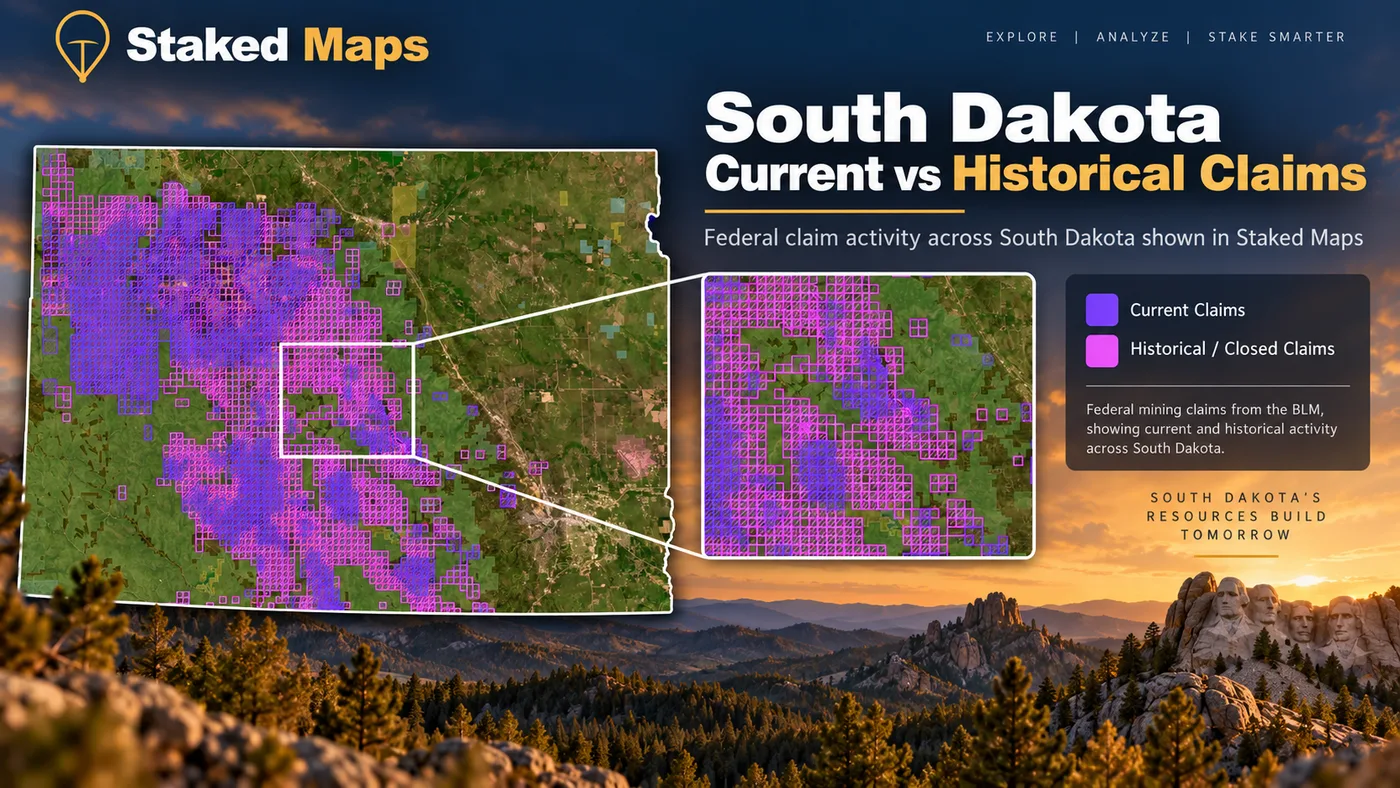
South Dakota has about 20 historical/closed claim records for every current/not-closed record in the present Staked Maps dataset. That ratio describes records, not acreage or unique mining locations, but it shows how much recorded activity disappears when a map displays only current claims.
Current vs. historical in the Black Hills: purple shows current/not-closed claim and site records; pink shows historical/closed records. Claim data: BLM MLRS; visualization: Staked Maps.
Historical claims can help identify places that saw repeated mineral-location activity, show how the footprint of a mining district changed over time, and reveal areas where today’s claim pattern is only a fraction of the recorded history. They do not prove that minerals remain, that old workings are safe to enter, or that ground is currently open to mineral entry.
In Staked Maps, current claims are shown separately from the historical/closed layer so you can compare today’s recorded activity with previous claim patterns. For safety and research context, see Abandoned Mines and Historical Mining Claims.
See historical claim activity in Staked Maps
Historical claims are included with paid mining plans.
Why Can a Mining Claim Appear on Black Hills National Forest Land?
Surface management and mineral administration are not always the same thing. The BLM South Dakota Field Office reports managing more than 274,000 surface acres and around 1.7 million acres of subsurface mineral estate in South Dakota. The mineral estate extends far beyond the acreage where BLM manages the surface.
BLM’s guidance on locating a mining claim states that claims can be located on open public land administered by another federal agency, most commonly Forest Service land. In the Black Hills, the Forest Service manages the National Forest surface, while federal mining claims on that ground are still recorded with and administered by BLM.
This is why the Surface Management Agency layer should not be read as a mineral-ownership map. Seeing USFS, BLM, State, NPS or Other Federal surface management tells you who manages the surface shown by that dataset. It does not, by itself, establish ownership of the mineral estate or whether mineral entry is allowed. For more on the difference, see Mineral Rights vs. Mining Claims.
BLM reports more than 274,000 surface acres and around 1.7 million acres of subsurface mineral estate in South Dakota. Staked Maps’ SMA colors represent surface management, not mineral ownership.
No Current Claim ≠ Open Ground in the Black Hills
A blank space between current mining claims answers one question: Staked Maps is not showing a current/not-closed BLM claim or site record at that mapped location. It does not answer every question required before prospecting or locating a new claim.
In South Dakota that blank space deserves extra caution. 2,289 current records in this snapshot have no mappable location in the BLM source data, so a current claim can exist on ground where the map shows nothing. Check BLM MLRS and the county record, not the map alone.
The absence of a mapped current claim does not establish mineral-entry status. Research claim records, surface management, mineral ownership and applicable withdrawals or restrictions.
Before treating an area as potentially available, research at least:
Current and historical claim activity. Check BLM’s current records and look for existing field monuments.
Surface management. Determine which agency or owner manages the surface.
Mineral estate. Surface management and mineral ownership can differ.
Mineral withdrawals and special restrictions. Some federal lands are closed or restricted for mineral entry even when no current claim is shown.
Access and activity-specific rules. Prospecting, mechanized equipment, water use and collecting can be regulated separately.
BLM’s own guidance states that claims may be located only on federal land open to mineral entry. It lists areas closed to mineral entry, including national parks, national monuments, designated Wilderness, American Indian reservations and lands withdrawn from mineral entry.
Research the Black Hills with the layers together
Start with current claims and surface management for free. Paid mining plans add historical claims, full legal-location details, PLSS research layers, BLM record links and offline maps.
Do You Need a Permit to Pan or Prospect for Gold in South Dakota?
South Dakota’s state requirements depend partly on the equipment being used. The South Dakota Department of Agriculture and Natural Resources Minerals and Mining Program says no mine permit is required for placer mining with hand-held equipment such as a pick, shovel, pan, metal detector or sluice box, although state water quality standards still apply. Operating any type of dredge requires a mining permit, even for recreational purposes, and mine permits are also required for other mechanized equipment such as highbankers. DANR also says a water right permit is required for placer mining activities, and that some Black Hills streams are fully appropriated, so a water right permit may not be obtainable.
Activity
South Dakota mine permit
Important qualification
Gold pan
Not required
Land access and other applicable rules still apply
Pick or shovel
Not required
Land access and other applicable rules still apply
Sluice box
Not required
Water-quality and water-right requirements may apply
Metal detector
Not required
Land-manager restrictions still apply
Highbanker
Required
DANR classifies this as mechanized equipment
Dredge (any type)
Required
Water-quality and water-right requirements also matter
This is a research summary, not a permit determination for a specific site or activity. Check current DANR requirements and the rules of the agency or owner managing the land before beginning work. On National Forest land, the Black Hills National Forest publishes its own guidance on gold panning, rockhounding and metal detecting.
South Dakota Mining Claims Also Have State Recording Requirements
Federal BLM filing is not the only record a South Dakota claimant may need to research. South Dakota law contains separate location and recording requirements in South Dakota Codified Laws, Chapter 45-4, and DANR directs anyone filing mining claims to comply with that chapter in addition to federal requirements.
For example, SDCL 45-4-4 states that the discoverer of a lode must record the claim with the register of deeds in the county where the lode is located within sixty days of discovery. The location certificate must contain the name of the lode, the locators, the date of location, the claimed length and width, and a description tied to a natural object or permanent monument. A lode location certificate missing that information is void. Separately, SDCL 45-4-23 requires an affidavit of labor, or of compliance with federal requirements, to be recorded with the register of deeds by December 30 following each federal assessment year.
For claim research, that means the useful record trail can involve more than one source:
BLM MLRS → South Dakota law → county Register of Deeds
Staked Maps helps organize the federal spatial and case-record research, but it does not replace the official federal or county record.
Why Is Mining Activity So Concentrated in the Black Hills?
The Black Hills contain a complex core of Precambrian crystalline and metamorphic rocks surrounded by younger sedimentary formations. USGS mapping of the central Black Hills documents Early Proterozoic granitic rocks, Early Proterozoic metamorphic rocks and Archean crystalline basement, along with younger structures and intrusive rocks.
The geology produced more than one kind of mineral target. USGS describes Black Hills granitic rocks as hosting pegmatites known for feldspar, mica, spodumene and beryl, while the metamorphic rocks host the Homestake gold mine. USGS reports that Homestake produced more than 40 million ounces of gold over a 125-year lifetime.
That geologic variety helps explain why the Staked Maps record set contains both a large concentration of lode claims and a separate pattern of documented mineral occurrences. Geology can help explain where exploration has occurred, but it does not establish present-day ownership, access or mineral-entry status.
The 1874 Gold Discovery Changed the Black Hills
The Black Hills gold rush cannot be separated from the land’s treaty history. The 1868 Treaty of Fort Laramie set aside the Black Hills within the Great Sioux Reservation for the Lakota and other tribal nations. In 1874, George A. Custer’s Army expedition entered the Black Hills and confirmed the presence of gold. According to the National Park Service, prospectors then flooded into the area in violation of the treaty, contributing to the Great Sioux War of 1876 and 1877. An 1876 agreement amended the 1868 treaty to remove the Black Hills from the reservation.
That history matters on a modern mining page because the Black Hills are not simply a collection of old gold districts. Present-day research crosses federal, Forest Service, state, private and tribal land contexts, and those distinctions matter when interpreting a claims map.
What Do South Dakota’s Mineral-Occurrence Records Show?
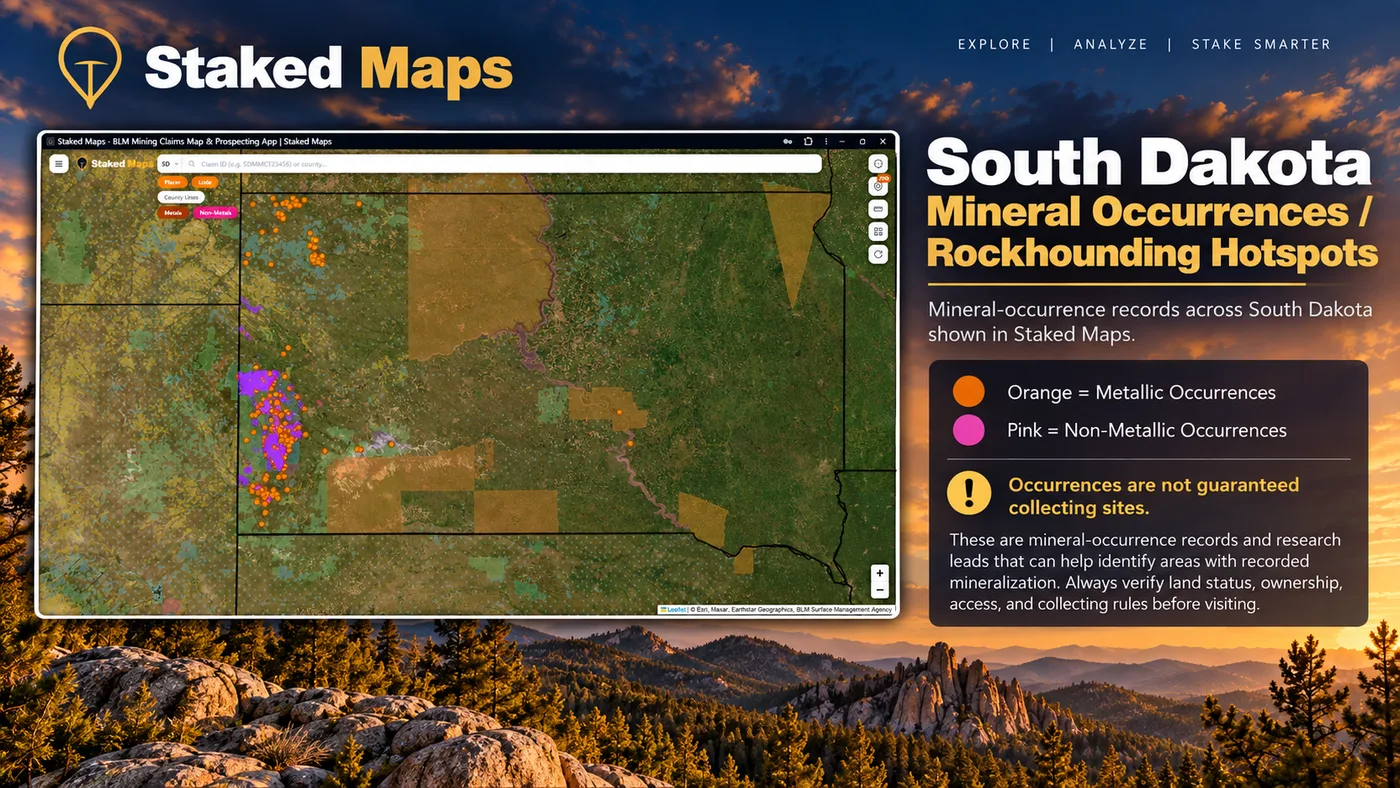
Staked Maps currently contains 1,601 South Dakota mineral-occurrence records derived from the USGS Mineral Resources Data System: 1,595 classified as metallic and 6 as non-metallic in the present dataset. In the application these records power the Rockhound Hotspots research layer.
These records represent documented mineral occurrences, prospects and mines used as research leads. They are not a directory of verified public collecting sites, and a mapped occurrence does not establish public access, permission to collect, mineral ownership or current land status.
1,595
Metallic Records
99.6%
6
Non-Metallic Records
0.4%
A record is grouped as non-metallic when its MRDS commodity codes include a gem or lapidary material, and as metallic otherwise. Records listing only bulk industrial or energy commodities were excluded.
Materials Listed in South Dakota’s Non-Metallic Records
The table covers only the 6 non-metallic records. Most of them list several materials, so the rows add up to more than that total.
Material
Records Listing Material
Beryl
3
Garnet
3
Quartz
3
Tourmaline
3
Abrasive
1
Andalusite
1
Feldspar
1
Stone
1
Zircon
1
The Black Hills’ pegmatite geology is particularly significant for mineral research, and USGS describes pegmatites there containing feldspar, mica, spodumene and beryl. South Dakota law (SDCL 1-6-12) separately designates the Fairburn agate as the state gemstone and rose quartz as the state mineral stone.
Mineral-occurrence records are research leads, not guaranteed collecting sites. Verify land status, access and collecting rules before visiting.
How to Research a South Dakota Prospecting Area in Staked Maps
Step 1
Start With Current Claim Activity
Look for current/not-closed BLM claim and site records in the area.
Step 2
Turn On Surface Management
Identify the agency shown as managing the surface. Remember that surface management does not by itself establish mineral ownership.
Step 3
Compare Historical Activity
Use the historical claims layer to see where past recorded activity extends beyond today’s current claims.
Step 4
Add PLSS and Supporting Layers
Use township, range and section information and relevant field layers to understand the location in the same framework used by public land records.
Step 5
Open the Underlying Claim Record
Review status, legal description and BLM record information. Verify official records before making a legal or field decision.
Step 6
Check State and Land-Manager Rules
South Dakota mine-permit, water, Forest Service and other site-specific requirements can apply independently of claim status.
Current claims and surface management are on the free map. Historical claims, PLSS, full claim details and offline maps are part of the paid mining plans.
Put the South Dakota layers together
Current claims and surface management are available on the free map. Paid mining plans add historical claims, full legal-location details, PLSS research layers, BLM record links and offline access.
Authoritative federal case-record research for mining claims and sites. BLM also requires claims and sites to be recorded with the proper BLM state office within 90 days of location.
Leasing information for state-owned school and endowment lands and minerals. State-owned mineral interests are administered under South Dakota’s state leasing system rather than located as federal mining claims. Check School and Public Lands records when state mineral ownership may be involved.
Federal historical context for the 1868 treaty, the 1874 gold discovery and the conflict that followed.
County Register of Deeds. South Dakota lode location certificates and annual affidavits are recorded in the county where the claim is located, so the county register of deeds is the place to check state-level claim records.
Staked Maps is not an official substitute for any of these sources, and none of these agencies endorses Staked Maps.
What Premium Adds to Your South Dakota Map
Historical Claims. See where mining activity existed before today's current records.
Full Claim Details. Serial number, legal location information and a direct path back to the official BLM record.
Research Layers. PLSS, roads/trails, waterways and South Dakota mineral occurrences.
Offline Maps. Save your South Dakota research before losing cell service.
Field Tools. Directions, custom pins, measurements and claim-drafting tools.
Single State unlocks all premium features for South Dakota for $29.99/year.
Plans
Choose Your Plan
Basic
Free
Try Staked Maps in one state.
$0/mo
✓Interactive mining claims map — pick your state (or use your location)
✓Surface management overlays & current mining claims
✓Claim type, name, status & size in claim popups
Paid plans unlock full claim details, historical claims, research layers and offline tools.
Single State, Tri-State and All-West all unlock the exact same features — nothing is pay-gated between them, they differ only in how many states you get.
Paid plans renew automatically at the monthly or annual rate you choose until you cancel. Cancel anytime and keep access through the end of your paid period. See our Terms of Use.
Single State, Tri-State and All-West unlock the identical feature set — only the number of states differs.
National Rockhound Pass is a separate, nationwide-but-lighter product built for rockhounds outside the core mining states.
Free
Single State
Tri-State
All-West
Rockhound Pass
Geographic coverage
1 state (view only)
1 state, full data
3 states, full data
13 Western states, full data
All 50 states, safety layer only
Interactive claims map, basemaps, compass, county search
✓
✓
✓
✓
✓
Surface management (public/private land) overlay
✓
✓
✓
✓
✓
Claim type, name, status & size in popups
✓
✓
✓
✓
✓
Full legal location (aliquot description)
✕
✓
✓
✓
✕
Claim serial number, owner intel, BLM Records & 'Directions' button
✕
✓
✓
✓
✕
Search by claim number
✕
✓
✓
✓
✕
Custom pins & distance measure tool
✕
✓ (up to 50)
✓ (up to 50)
✓ (up to 50)
✓
Expired & historical claims layer
✕
✓
✓
✓
✕
Placer/Lode claim filters & latest synchronized data
Staked Maps processes publicly available Bureau of Land Management claim records and synchronizes them into a map designed for field research. It is not a substitute for the official record.
Current/not-closed records: Federal mining claim and site records come from the Bureau of Land Management’s Mineral & Land Records System (MLRS). Staked Maps synchronizes those records into its research database; a record remains in the current/not-closed dataset until it is marked closed through that process.
BLM disposition: Retained separately as source data from BLM (Active, Filed, Under Review, Submitted or any other status present). BLM case-type values are normalized into Lode, Placer, Mill Site and Tunnel Site.
Historical claims: Sourced from BLM’s historical/closed-claims layer. Staked Maps does not represent its local historical cache as a complete archival mirror of every BLM record.
Sync schedule: Nightly incremental sync, a weekly full reconciliation, and a monthly cross-check against BLM’s closed-claims layer.
Claim geometry: Claim polygons are research approximations derived from recorded legal land descriptions under the Public Land Survey System. Most come from BLM’s own approximation of the legal description at aliquot or section resolution; where BLM supplies no polygon, Staked Maps draws an approximate rectangle from the legal description. They are not professional land surveys and should not be treated as exact surveyed claim boundaries.
Counties: County assignment is a spatial match against U.S. Census county boundaries, not a county field supplied by BLM. 2,289 South Dakota current records have no usable map location in the BLM source data yet, so they cannot be assigned to a county; they are still counted in statewide totals.
Rockhound / mineral data: Sourced from USGS MRDS. South Dakota mineral-occurrence records are derived from USGS Mineral Resources Data System records and classified by material where source information permits. These are occurrence, prospect and mine research records, not verified public collecting sites.
Land / PLSS: The Surface Management Agency layer is based on BLM’s official SMA service. SMA colors describe surface management. They do not, by themselves, establish mineral ownership, mineral-entry status or permission to prospect.
Limitations: For legal filings, boundary-sensitive decisions or questions about whether land is open to mineral entry, verify the official record and applicable agency requirements.
Frequently Asked Questions
How many current mining claims are in South Dakota?
As of September 28, 2026, Staked Maps has 11,360 current/not-closed federal mining claim and site records for South Dakota. BLM labels 10,958 Active, 396 Filed, 4 Under Review and 2 Submitted. "Current/not closed" is therefore broader than the BLM Active disposition. These are administrative record statuses, not a legal determination of claim validity.
Where are most South Dakota mining claims located?
Current federal claim records are concentrated heavily in the Black Hills. Lawrence County ranks first in the present dataset, followed by Custer County and Pennington County. Together they hold 75.3% of South Dakota's current/not-closed records. Another 2,289 records have no mappable location in the BLM source data and are not assigned to any county.
Can mining claims exist on Black Hills National Forest land?
Yes. The Forest Service manages National Forest System surface, and BLM states that mining claims can be located on open public land administered by another federal agency, most commonly Forest Service land. Whether a specific location is open to mineral entry still must be verified.
Does no current mining claim mean the land is open?
No. The absence of a mapped current claim does not establish that land is open to mineral entry. Surface management, mineral ownership, withdrawals, existing rights, access restrictions and other rules can still control what is allowed. In South Dakota, some current records also have no mappable location, so a claim can exist where the map shows none.
Do I need a South Dakota permit to pan for gold?
South Dakota DANR says no mine permit is required for placer mining with hand-held equipment such as gold pans, picks, shovels, sluice boxes and metal detectors. Any dredge, and mechanized equipment such as highbankers, requires a mine permit. Water-quality standards apply, and DANR says a water right permit is required for placer mining activities.
Does South Dakota require mining claims to be recorded with the county?
Yes. South Dakota has state recording requirements in SDCL Chapter 45-4 in addition to federal requirements. For example, a lode location certificate must be recorded with the register of deeds in the county where the lode is located within sixty days of discovery and must contain specified information, and an annual affidavit must be recorded by December 30 after each federal assessment year.
What are South Dakota Rockhound Hotspots in Staked Maps?
They are documented mineral-occurrence, prospect and mine records derived from USGS data. They are research leads, not a list of locations where collecting is guaranteed to be legal or permitted.
Are Staked Maps claim boundaries exact surveyed boundaries?
No. Staked Maps uses recorded legal land descriptions to create practical research polygons. Those polygons should not be treated as professional surveys or used to establish an exact legal boundary.
Can I use Staked Maps offline in the Black Hills?
Yes. Paid mining plans allow supported map areas and research layers to be saved for offline use before entering areas without reliable cellular service.
Information hosted on Staked Maps is compiled from publicly available data
streams provided by the Bureau of Land Management (BLM) and relevant state
geographic clearinghouses. Staked Maps accepts no liability for the content of
this geospatial data, or for the consequences of any real-world exploration,
land entry, or staking actions taken on the basis of the information provided
via this application interface.
Staked Maps makes no warranty, expressed or implied, including the warranties of
merchantability and fitness for a particular purpose, nor assumes any legal
liability or responsibility for the pinpoint accuracy, reliability, completeness,
latency, or programmatic utility of these geospatial data layers, or for the
improper interpretation of these data grids.
These mapping layers and related graphics are visual convenience aids only; they
are not legal documents and must never be used as such. The data may not be used
to legally determine title, mineral ownership, valid description boundaries,
jurisdictional authorities, or land restrictions in place on public or private
land. Natural backcountry hazards may or may not be depicted on topographies, and
land users are strictly mandated to exercise caution. Federal records are dynamic
and change constantly. The end-user is exclusively responsible for validating
current land classifications with the BLM South Dakota Field Office, the county register of deeds, or South Dakota DANR for state permits and managing compliance
accordingly.