New Mexico Mining Claims Map: Current BLM Claims & Land Ownership
New Mexico currently has 14,434 current/not-closed federal mining claim and site records in the Staked Maps database. Of those, BLM labels 12,069 Active, with the remaining current records in Filed, Under Review or other non-closed dispositions shown in the data.
Claim activity is heavily concentrated in a few counties: Grant County, Hidalgo County and Catron County hold 62.4% of current records. A mining-claim map answers only one part of the land-research question, so Staked Maps places current claims, historical claims, surface-management boundaries, PLSS information and documented mineral occurrences together to help you investigate an area before heading into the field.
A gap between mapped claims does not prove that land is open to prospecting or new claim location. State Trust land, private land, tribal land, federal withdrawals, split mineral ownership, existing rights and other restrictions can still apply.
Free account · No credit card required · Opens directly to the New Mexico map
Current claims and surface-management land status together in one New Mexico map.
New Mexico Mining Claims at a Glance
14,434
Current / Not-Closed Federal Claim & Site Records
195,762
Historical Claim Records
4,624
Documented Mineral Occurrence Records
Mining claim data synchronized: . Federal claim records are sourced from BLM MLRS and synchronized on Staked Maps’ normal data schedule, not live with every page visit. Mineral-occurrence records are research data derived from USGS MRDS.
Current Does Not Mean the Same Thing as BLM Active
Staked Maps uses current/not-closed for BLM mining claim and site records that have not been identified as Closed in the source dataset. That total includes records BLM labels Active as well as Filed, Under Review and any other non-closed dispositions present in the current data.
That distinction matters. A Filed or Under Review record should not be presented as though BLM has assigned it the same case disposition as an Active record. Current/not-closed and BLM Active are not interchangeable statuses.
BLM Status
Records
Share of Current Records
Active
12,069
83.6%
Filed
1,751
12.1%
Under Review
614
4.3%
Total Current / Not-Closed
14,434
100%
BLM case status is research information, not a Staked Maps determination that a claim contains a valid mineral discovery, is legally valid in every respect or gives permission to enter the land. Verify an individual record through BLM MLRS when the distinction matters.
What Types of Mining Claims Are Current in New Mexico?
New Mexico’s current federal record population is overwhelmingly lode-oriented, with a much smaller placer share and a small number of Mill Sites and Tunnel Sites.
13,298
Lode Claims
1,010
Placer Claims
120
Mill Site Records
6
Tunnel Site Records
Record Type
Current Records
Share of Current Total
Lode
13,298
92.1%
Placer
1,010
7.0%
Mill Site
120
0.8%
Tunnel Site
6
<0.1%
Lode records account for 92.1% of New Mexico’s current claim and site records, roughly nine of every ten, while placer records make up 7.0%. Mill Sites and Tunnel Sites are separate location types under the Mining Law, not additional mineral commodities.
The record type tells you how a mineral location was filed. It does not establish mineral potential on neighboring ground or determine whether nearby land is open to new claim location.
Where Are New Mexico’s Current Mining Claims Concentrated?
County counts are calculated directly from the Staked Maps database by matching each record’s mapped location to U.S. Census county boundaries. Separately, 32 current New Mexico records in this snapshot could not be matched to a county. They are still counted in the statewide total.
Current mining activity is not evenly distributed across New Mexico. Grant County, Hidalgo County and Catron County account for approximately 62.4% of the state’s current mapped federal claim and site records. That concentration makes county-level claim data useful for understanding where modern recorded activity is clustered, but claim density by itself does not establish mineral quality or whether adjacent land is available for prospecting.
Grant County alone holds 30.9% of the statewide total. The county mix also varies more than the statewide 92.1% lode figure suggests. Among counties with at least 500 current records, McKinley County (100.0% lode) and Catron County (99.9% lode) are the most lode-oriented, while Sierra County (15.2% placer) is the most placer-oriented. In absolute terms, Hidalgo County has the most placer records: 278, or 27.5% of New Mexico’s current placer total.
Remaining New Mexico Counties With Current Mining Claim Records
One of the most important New Mexico-specific land-research issues is State Trust Land. The New Mexico State Land Office manages approximately 9 million surface acres and 13 million mineral acres across every county in the state.
State Trust Land is not the same thing as BLM public land. The State Land Office manages it to raise revenue for New Mexico public schools, hospitals, colleges and other public institutions, and its recreational-access rules are different from federal public-land rules.
A New Mexico recreational access permit does not authorize mineral exploration, mining or the collection of valuable rocks or minerals on State Trust Land. The State Land Office lists “mineral exploration, development, or mining, or collecting valuable rocks or minerals” among the activities prohibited under that permit.
No Current Claim ≠ Open Ground
A mining-claim layer tells you whether Staked Maps is showing recorded claim activity at a location. It cannot, by itself, establish that the land is legally available for mineral entry.
What an Empty Claim Map Can Hide
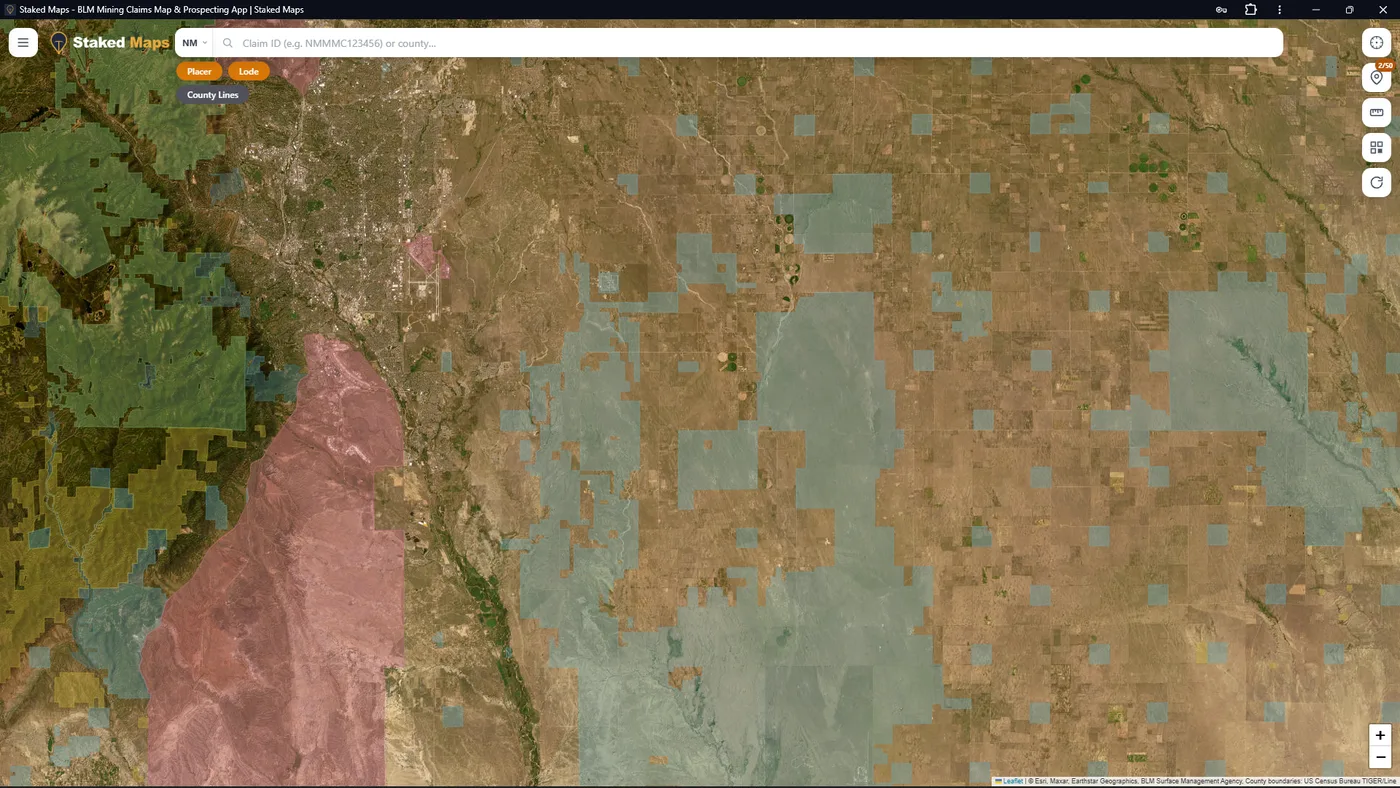
The screenshot below shows central New Mexico east of Albuquerque with the surface-management layer turned on. No current federal mining claims appear anywhere in view. That empty claim layer is not a sign of open ground: across most of the frame, the mapped surface is State Trust parcels (blue) scattered through unshaded land that no federal or state agency manages, typically private property, with National Forest land to the west.
Federal mining claims can only be located on federal minerals that are open to mineral entry. State Trust minerals are managed by the State Land Office under state rules, and private surface can sit over either private or federally reserved minerals, which has to be researched separately. So before treating any location as potential prospecting ground, you still need to determine who manages the surface, who controls the mineral estate, whether the minerals are open to entry and whether any withdrawal or other restriction applies.
Why the land layer matters: this stretch of central New Mexico shows no current federal mining claims, but most of it is State Trust (blue) or unshaded private land rather than BLM public land. A gap in the claim layer is where land research starts, not where it ends.
New Mexico Mining Claims Map: What It Can and Cannot Tell You
Can help you
See mapped current BLM mining claim and site records.
Distinguish BLM Active records from other current/non-closed statuses.
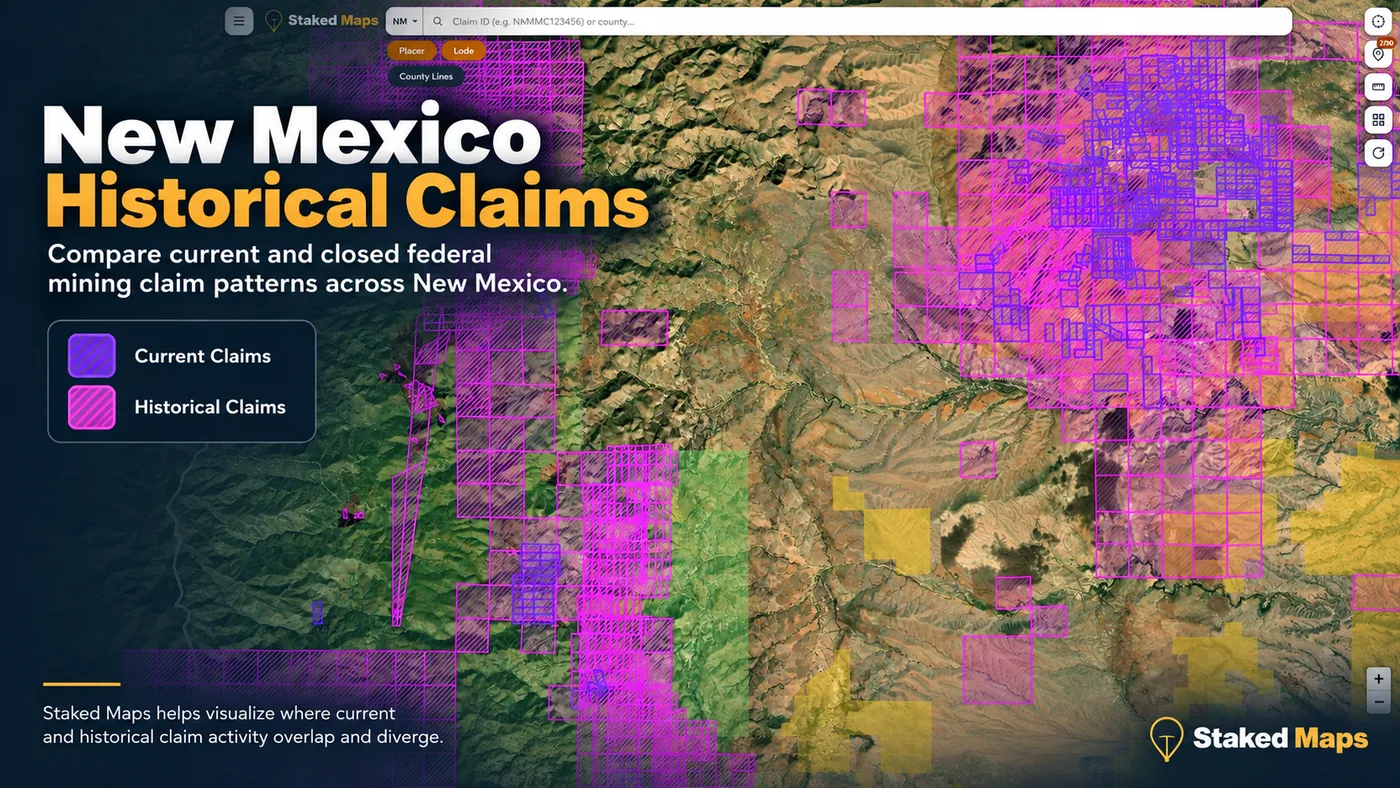
Compare current and historical claim activity.
See lode, placer, mill-site and tunnel-site records.
View surface-management information beside mining claims, including New Mexico State Trust land.
Research recorded mineral occurrences.
Use PLSS and claim details as part of a broader land-research workflow.
Save applicable map areas for offline field use on paid plans.
Cannot by itself
Prove that land is legally open to mineral entry.
Establish mineral ownership or legal title.
Establish that a mapped claim boundary is survey-grade.
Give permission to cross private or tribal land.
Authorize mineral collecting on New Mexico State Trust Land.
Determine whether land is withdrawn from mineral entry.
Give permission to prospect on another person’s valid mining claim.
Replace BLM MLRS, county records, State Land Office records, USFS regulations or other official sources.
Use Staked Maps to organize the research, then verify the official record and the rules that apply to the specific ground before acting on it.
What Do New Mexico’s Historical Mining Claims Tell You?
Staked Maps currently contains 195,762 historical federal mining claim records for New Mexico, far more than the 14,434 current/not-closed records. Those closed and historical records can reveal where claim activity was recorded in the past even when the same location is no longer represented by a current claim.
Historical activity can be useful when researching an old mining district, drainage or mineral belt, but it answers a different question from current claim status. A historical claim does not prove that economically recoverable minerals remain, that old workings are safe or that the land is now legally open to prospecting.
The useful research workflow is to compare historical activity with today’s current claims, surface management, mineral occurrences and official land-status records rather than relying on any single layer.
Current and historical records answer different research questions. Historical activity can identify places worth investigating, while current claim and land-status records help establish what needs to be checked today.
New Mexico’s Mining Districts and Placer-Gold History
New Mexico’s mining history is spread across far more than a handful of famous gold camps. The New Mexico Bureau of Geology and Mineral Resources’ statewide Resource Map 24identifies 246 mining districts and prospect areas, excluding coal fields.
Placer gold is only one part of that history. NMBGMR estimates that approximately 662,000 ounces of placer gold were produced in New Mexico from 1828 to 1991. Only four districts are reported to have each produced more than 100,000 ounces of placer gold:
Elizabethtown-Baldy (Colfax County, northern New Mexico). NMBGMR notes that thicker placer deposits occur in this district, up to 275 feet.
Hillsboro (Sierra County). The same county has 1,096 current federal claim and site records today; see the Sierra County mining claims page.
Old Placers (Ortiz Mountains, Santa Fe County). According to NMBGMR, the 1828 discovery of large placer deposits here began one of the earliest gold rushes in the western United States.
New Placers (San Pedro Mountains area around Golden, Santa Fe County). NMBGMR notes that environmental and permitting restrictions have hampered recent production in this district.
Historical production is not evidence that the same ground is open today or that commercially recoverable gold remains there. NMBGMR states that “most known economic placers in the state have been worked” and that future economic potential will depend on the discovery of large-volume, medium-grade deposits that can be mined by bulk methods.
Why That History Is Useful on a Modern Claims Map
Mining-district history provides context. Current claim records show where activity remains recorded today; historical claims show where claims existed previously; mineral-occurrence records identify documented mineral sites; and surface-management information helps identify the agencies or owners that must be considered before field activity.
Those layers together are considerably more useful than treating an old gold-district name as proof that an individual parcel is available or productive.
New Mexico Mineral Occurrences & Rockhounding Research
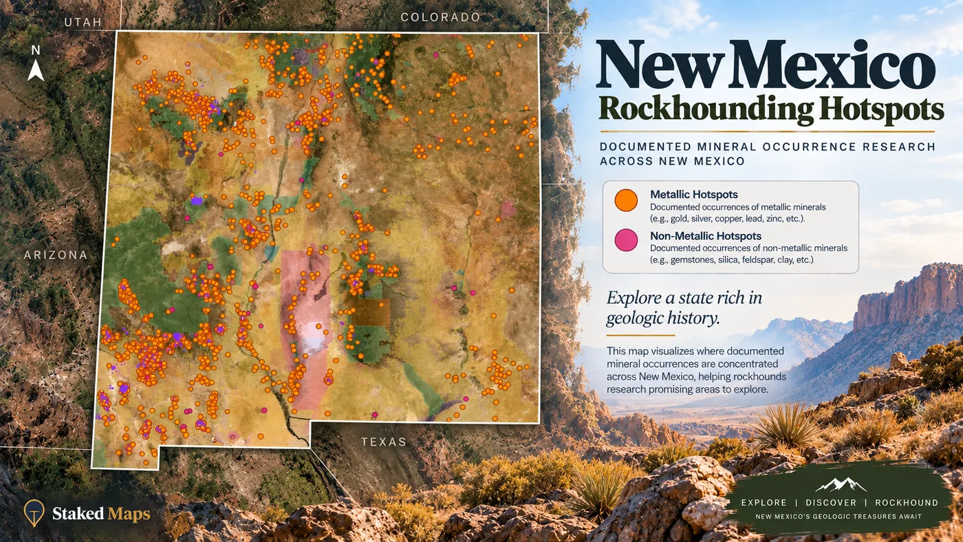
Staked Maps currently includes 4,624 documented New Mexico mineral-occurrence records derived from the USGS Mineral Resources Data System. In the application these records power the Rockhound Hotspots research layer.
MRDS records can represent mineral occurrences, prospects, mines and other documented mineral sites. They should be treated as research leads, not as a directory of legally accessible collecting locations.
4,543
Metallic Records
98.2%
81
Non-Metallic Records
1.8%
These two groups follow the classification Staked Maps applied when building this layer from MRDS data: a record is grouped as non-metallic when its MRDS commodity codes include a gem or lapidary material (gemstone, quartz, kyanite-group minerals, olivine or garnet and corundum abrasives), and as metallic otherwise. Records listing only bulk industrial or energy commodities, such as coal, clay, aggregate or gypsum, were excluded. In the data checked September 28, 2026, 12 of the 81 non-metallic records also list a metal, including 6 that list gold.
Materials Listed in New Mexico’s Non-Metallic Records
The table covers only the 81 non-metallic records. A record can list more than one material, so the rows do not add up to that total. “Gemstone” and “Semiprecious” are broad MRDS categories rather than specific minerals.
Material
Records Listing Material
Gemstone
22
Quartz
22
Kyanite
20
Semiprecious
11
Turquoise
9
Agate
7
Fluorine-Fluorite
3
Abrasive
2
Chalcedony
2
Chrysocolla
2
Commodity names in legacy mineral databases can be broad, overlapping or incomplete. A listed material does not establish current abundance, collecting quality, public access or permission to remove specimens.
Metallic (orange) and non-metallic (pink) mineral-occurrence records across New Mexico. Check the land status of any individual record before field use, including whether it falls on State Trust land.
How to Research a New Mexico Prospecting Area Before You Go
Step 1
Check Current Claim Activity
Start with current/not-closed BLM records in the area. Open individual claim details instead of assuming an empty-looking space means unclaimed ground.
Step 2
Compare Historical Activity
Turn on historical claims and mineral-occurrence layers to see whether mining or mineral activity has been recorded in the area before.
Step 3
Check Surface Management
Determine whether the mapped surface is BLM, National Forest, New Mexico State Trust, private, tribal or another management category. Surface management does not automatically establish mineral ownership.
Step 4
Narrow the Legal Location
Use PLSS information and the recorded claim details to understand how current federal records are described and where additional official research is needed.
Step 5
Verify the Official Record and Local Rules
Check the current BLM MLRS record and the agencies responsible for the specific land. County recording requirements, State Trust rules, Forest Service restrictions, withdrawals, access restrictions and other requirements may also apply.
Staked Maps helps bring map-based research layers together. It is not a legal determination, title search, proof that land is open or proof that land is unclaimed.
Research New Mexico on the Free Map
Start with current claims and surface-management layers. Upgrade only if you need historical claims, complete claim details, offline maps and premium research layers.
Single State, Tri-State and All-West all unlock the exact same features — nothing is pay-gated between them, they differ only in how many states you get.
Paid plans renew automatically at the monthly or annual rate you choose until you cancel. Cancel anytime and keep access through the end of your paid period. See our Terms of Use.
Single State, Tri-State and All-West unlock the identical feature set — only the number of states differs.
National Rockhound Pass is a separate, nationwide-but-lighter product built for rockhounds outside the core mining states.
Free
Single State
Tri-State
All-West
Rockhound Pass
Geographic coverage
1 state (view only)
1 state, full data
3 states, full data
13 Western states, full data
All 50 states, safety layer only
Interactive claims map, basemaps, compass, county search
✓
✓
✓
✓
✓
Surface management (public/private land) overlay
✓
✓
✓
✓
✓
Claim type, name, status & size in popups
✓
✓
✓
✓
✓
Full legal location (aliquot description)
✕
✓
✓
✓
✕
Claim serial number, owner intel, BLM Records & 'Directions' button
✕
✓
✓
✓
✕
Search by claim number
✕
✓
✓
✓
✕
Custom pins & distance measure tool
✕
✓ (up to 50)
✓ (up to 50)
✓ (up to 50)
✓
Expired & historical claims layer
✕
✓
✓
✓
✕
Placer/Lode claim filters & latest synchronized data
Federal land-management information, field-office contacts, land-use planning information and mining/mineral program guidance for New Mexico. Check BLM when researching federal land status, withdrawals, local restrictions and the appropriate field office for an area.
BLM’s authoritative federal system for researching individual mining claim and site records. Use MLRS to verify the current federal record before relying on a specific claim’s status or filing information. BLM also requires claims and sites to be recorded with the proper BLM state office within 90 days of the date of location, and with the proper county in accordance with county requirements, so county records are a second place to check.
Manages approximately 9 million surface acres and 13 million mineral acres of New Mexico State Trust Land. Check State Land Office information whenever Staked Maps indicates State Trust land or when mineral ownership and access require further investigation.
New Mexico’s state geological survey and a major source for geologic mapping, mining-district research, mineral resources and historical mining publications. Use NMBGMR when researching mining districts, mineral occurrences, placer history and geologic context.
Administers the Mining Act Reclamation Program, which regulates hard-rock mining reclamation under the New Mexico Mining Act of 1993, along with mine registration, abandoned-mine and other mining-related programs. Use MMD resources when researching state hard-rock mining requirements, mine permits, exploration projects or reclamation records.
Manages National Forest System lands across New Mexico and publishes rules and guidance relevant to mineral activities and recreational collecting on National Forest lands. Check the applicable National Forest or ranger district before prospecting or collecting on Forest Service land.
Staked Maps is not an official substitute for any of these sources, and none of these agencies endorses Staked Maps.
Frequently Asked Questions
How many mining claims are current in New Mexico?
As of September 25, 2026, Staked Maps tracks 14,434 current/not-closed federal mining claim and site records in New Mexico from BLM source data. Of those, BLM currently labels 12,069 Active. The remainder are Filed, Under Review or another non-closed disposition present in the current dataset. “Current” and “Active” therefore are not interchangeable terms.
Where are most current mining claims in New Mexico?
New Mexico's current federal claim records are concentrated most heavily in Grant County, Hidalgo County and Catron County. Together those three counties account for approximately 62.4% of the state's mapped current claim/site records as of the data date above. Claim concentration shows recorded activity, not whether surrounding ground is legally open or mineralized.
Does land without a current mining claim mean I can prospect there?
No. An apparent gap in current claim records does not establish that land is open to mineral entry or prospecting. The ground may be State Trust land, private land, tribal land, withdrawn federal land, subject to split mineral ownership, covered by existing rights or affected by other restrictions. Treat a gap in the claim layer as a starting point for additional land-status research.
Can I collect minerals on New Mexico State Trust Land?
Do not assume that a recreational access permit allows mineral collecting on State Trust Land. New Mexico State Land Office recreational-access rules specifically prohibit mineral exploration, development or mining and collecting valuable rocks or minerals under that permit. Check directly with the State Land Office for the rules and authorization applicable to the activity you are considering.
What is the difference between current, Active and historical mining claims?
Current/not-closed is Staked Maps' description for BLM claim and site records that have not been identified as Closed in the source dataset. Active is a specific BLM case disposition. Historical records are closed or otherwise historical claim records retained for research into past activity. None of those labels by itself is a Staked Maps legal determination of claim validity or mineral ownership.
What do historical mining claims tell me?
Historical claims show where federal mining claim activity was recorded in the past. They can help identify old mining districts and previously claimed ground, but they do not prove that minerals remain, that old workings are safe or that the area is currently open to prospecting.
What are Staked Maps Rockhound Hotspots?
Rockhound Hotspots are documented mineral-occurrence records displayed as a research layer in Staked Maps. New Mexico records are derived from USGS MRDS data and can represent occurrences, prospects and mines. They are research leads, not verified public collecting sites.
Does the New Mexico map cover the whole state?
Yes. The interactive Staked Maps map covers New Mexico statewide. Dedicated county research pages currently exist for Grant, Luna, Taos, Sierra and Socorro Counties, and county search is available within the statewide map.
Which agency manages federal mining claims in New Mexico?
The Bureau of Land Management administers federal mining claim records through its Mineral & Land Records System (MLRS). New Mexico also has separate state, county, Forest Service, tribal, private-land and State Trust considerations depending on the location.
Can I use the New Mexico map without cell service?
Paid Staked Maps plans support offline map downloads. Save the required area before leaving service so applicable claim, surface-management and map layers remain available in the field.
Information hosted on Staked Maps is compiled from publicly available data
streams provided by the Bureau of Land Management (BLM) and relevant state
geographic clearinghouses. Staked Maps accepts no liability for the content of
this geospatial data, or for the consequences of any real-world exploration,
land entry, or staking actions taken on the basis of the information provided
via this application interface.
Staked Maps makes no warranty, expressed or implied, including the warranties of
merchantability and fitness for a particular purpose, nor assumes any legal
liability or responsibility for the pinpoint accuracy, reliability, completeness,
latency, or programmatic utility of these geospatial data layers, or for the
improper interpretation of these data grids.
These mapping layers and related graphics are visual convenience aids only; they
are not legal documents and must never be used as such. The data may not be used
to legally determine title, mineral ownership, valid description boundaries,
jurisdictional authorities, or land restrictions in place on public or private
land. Natural backcountry hazards may or may not be depicted on topographies, and
land users are strictly mandated to exercise caution. Federal records are dynamic
and change constantly. The end-user is exclusively responsible for validating
current land classifications with the BLM New Mexico State Office and field offices, or the New Mexico State Land Office for State Trust land and managing compliance
accordingly.