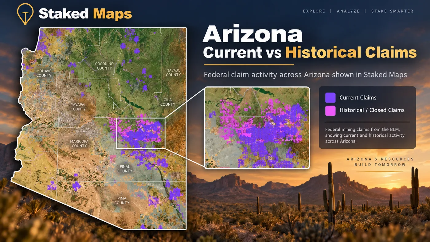
Arizona Mining Claims Map & Current BLM Claim Data
Research Arizona's current and historical federal mining claim records in one place, with claim status, land ownership, mineral-occurrence data and field-ready map layers. This page uses Staked Maps' Arizona dataset to show where current federal claim records are concentrated, how claim types differ across the state, and what land-status issues matter before you head into the field.
Arizona has extensive federal mineral lands, but a mining-claim map is only one part of land-status research. State Trust Land, private property, withdrawals, mineral ownership and other restrictions can all affect whether an area is available for prospecting, collecting or claim location.
Free account · No credit card required · Opens directly to the Arizona map
65,486
Current / Not-Closed Federal Records
433,739
Historical / Closed Records
Yavapai County
10,797 current records
Largest Current Concentration
10,208
Documented Mineral Occurrences
What Arizona's Current Mining Claim Data Shows
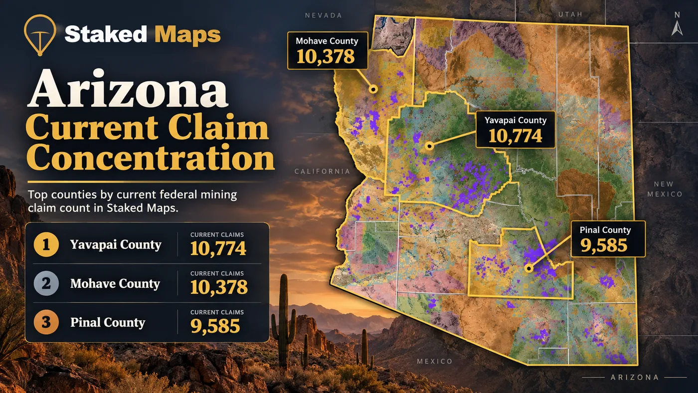
Staked Maps currently contains 65,486 current/not-closed federal mining claim and site records in Arizona. Yavapai County has the state's largest concentration with 10,797 records, or approximately 16.5% of the statewide current total. Mohave County follows with 10,379, while Pinal County contains 8,801.
Together, those three counties account for 29,977 current records, approximately 45.8% of Arizona's statewide total. The statewide number alone therefore does not show where federal claim activity is concentrated. County-level data gives a much clearer picture of how Arizona's current records are distributed.
By claim/site type, lode records are the largest category, representing 55,794 records, or approximately 85.2% of Arizona's current total. The remaining records include 6,522 placer claims (10.0%), 3,159 mill site claims (4.8%) and 11 tunnel site claims (<0.1%). That breakdown matters because a statewide count that reports only lode and placer claims can omit legitimate BLM site records.
Unlike some states where modern claim activity has shifted away from the historic gold-rush map, Arizona's current pattern largely tracks its 19th-century mining fame: Yavapai and Mohave counties, both major historic placer and hard-rock gold districts, are also today's two largest sources of current federal claim and site records. Pinal County's third-place position sits within a county with a long history of copper and gold mining, while Pima and Gila counties — both centers of Arizona's modern porphyry copper industry — carry an outsized share of mill site records relative to their overall claim counts, a pattern consistent with large-scale copper operations rather than placer or small lode districts.
Claim concentration is not a measure of mineral richness. A dense cluster of current federal records shows where claims and sites are concentrated in the BLM dataset. It does not prove production, mineral value, legal access or that nearby unclaimed-looking land is open to mineral entry.
How Many Arizona Mining Claims Are Actually Active?
The word active needs to be used carefully with federal mining records. Staked Maps' current/not-closed dataset can include several BLM status values, and not every record in that group is necessarily labeled Active by BLM.
"Current / not-closed" is a Staked Maps grouping used to separate records that are not in our closed/historical set. It is not itself a BLM status label. "Active" is one specific status recorded by BLM, so the number of records labeled Active may be lower than the complete current/not-closed total.
BLM Status
Records
Share of Current Records
Active
54,587
83.4%
Filed
9,947
15.2%
Under Review
952
1.5%
Why this matters: Staked Maps uses current/not-closed when referring to the entire group above. We reserve Active for records whose BLM status is actually Active. At the latest Arizona data synchronization, 54,587 records carry the BLM status Active, representing approximately 83.4% of the current/not-closed Arizona dataset. The remaining current records carry the other status values shown above.
This distinction is why Staked Maps now reports the broader statewide number as current/not-closed federal records instead of calling every non-closed record an active claim. A status shown in BLM records should still be independently verified before making filing, access, staking or other legal decisions.
Arizona Lode, Placer, Mill & Tunnel Sites
Federal mining records are not limited to lode and placer claims. Depending on the current Arizona dataset, BLM records can also include mill sites, tunnel sites and other site categories. Staked Maps includes every current Arizona claim/site type represented in the source data so the statewide total can be reconciled rather than leaving records unexplained.
55,794
Lode Claims
6,522
Placer Claims
3,159
Mill Site Claims
11
Tunnel Site Claims
Lode claims generally cover valuable mineral deposits occurring in rock in place. Placer claims generally cover valuable mineral deposits occurring in loose material rather than a vein or other deposit in place. Mill sites and tunnel sites serve different purposes under federal mining law and should not be counted as lode or placer claims. Arizona's 55,794 lode, 6,522 placer, 3,159 mill site and 11 tunnel site records add up to the full current/not-closed total of 65,486 — every current Arizona record is accounted for. See the official BLM Mining Claims resource.
Arizona Claims by Type, Visualized
Claim Type
Current Claims
Lode Claims
55,794 (85.2%)
Placer Claims
6,522 (10.0%)
Mill Site Claims
3,159 (4.8%)
Tunnel Site Claims
11 (<0.1%)
Explore Arizona Mining Claims on the Map
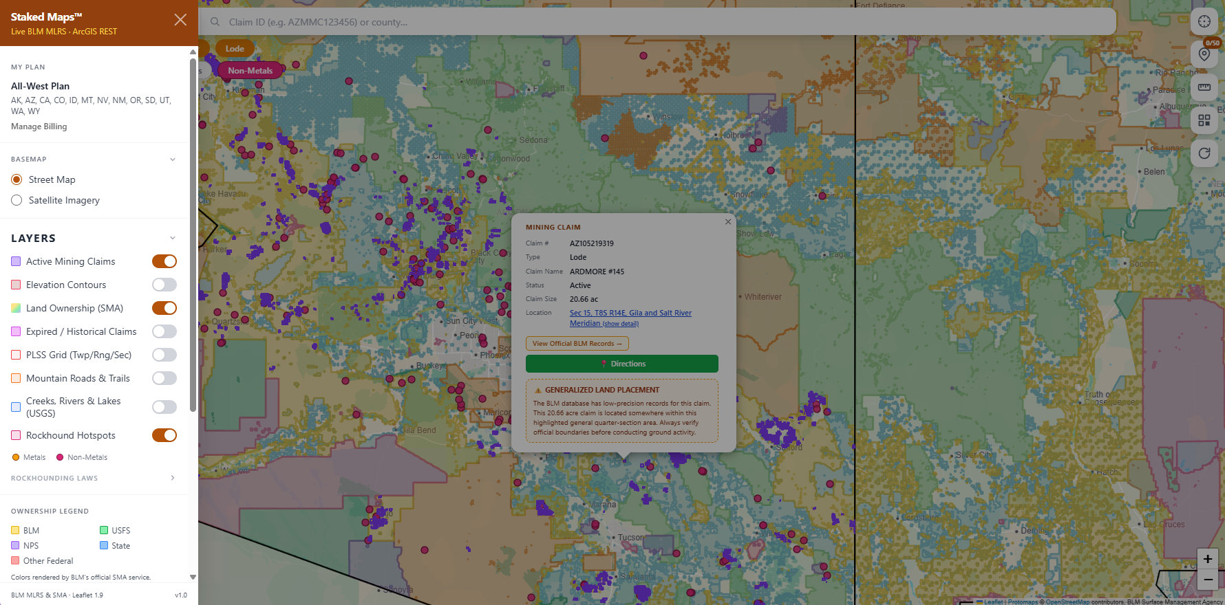
Statewide statistics are useful for understanding patterns, but individual research happens on the map. Staked Maps lets you move from Arizona-wide claim concentrations to individual federal records while adding land and terrain context to the same research session.
See what's recorded. View current federal claim and site records, inspect mapped locations and review available record details.
Add land context. Compare claim activity with land-ownership and other map layers instead of treating a blank area on a claim map as automatically open ground.
Take your research into the field. Paid plans add tools such as historical claims, additional research layers, claim-number search and offline map downloads for areas where cell service disappears.
Free account · No credit card required · Opens directly to Arizona
No Claim Shown Does Not Mean Open Ground
An area with no current mining claim displayed is not automatically open for prospecting or a new mining claim. Federal mining claims can only be located where the relevant public-domain mineral estate is open to mineral entry. Surface ownership, mineral ownership, withdrawals, existing rights and other land-use restrictions can change what is legally available even when no current claim polygon appears on the map.
Use Staked Maps to narrow your research. Verify legal land and mineral status with the appropriate government agency before locating a claim or beginning activity.
See where Arizona's current claim records are located
Open the free Arizona map to inspect recorded claims alongside surface-management boundaries.
The table shows Arizona's 14 counties with the most current records. Separately, 138 records in the statewide total cannot currently be assigned to a specific county because their BLM source geometry is incomplete or unresolved.
14 of Arizona's 15 counties currently show at least one current/not-closed record in this dataset. A county missing from the table has no current record matched to it in this synchronization; that is separate from the 138 statewide records noted above that could not be matched to any county at all.
What the County Data Tells Us
The county breakdown shows why claim type matters. Mohave County has the most lode records in the state, while Yavapai County has the most placer records. Yavapai's placer share (22.8% of its own current total) and La Paz County's placer share (20.5%) are both well above Mohave's (8.7%), reflecting Mohave's heavier concentration of hard-rock districts such as Oatman and Gold Basin. Pima and Gila counties, meanwhile, show the largest concentrations of mill site records relative to their own totals (15.0% and 12.4%) consistent with their modern porphyry copper operations rather than placer or small lode districts.
These figures describe the distribution of federal records, not the relative richness of the counties. Historic production, geology, land status and modern claim activity are related research signals, but none of them alone establishes where a prospector may legally work.
Explore Detailed Arizona County Research
Detailed county research pages are currently available for the following Arizona counties:
Arizona's Mining Regions: Desert Placers, Hard-Rock Districts & Copper Country
Arizona's mineral history does not come from one type of deposit or one part of the state. Historic placer districts, hard-rock gold systems and large copper-related mineral belts overlap a modern federal claim pattern that extends from the deserts of western Arizona into mountain districts in the center and southeast. These regions provide useful geological context for the current claim map, but historic mineralization does not establish present-day access or open ground.
Bradshaw Mountains & Central Arizona
The Bradshaw Mountains and surrounding Yavapai County districts contain some of Arizona's best-documented historic placer and lode gold country. U.S. Geological Survey research identifies the Weaver, or Rich Hill, placer district on the south flank of the Weaver Mountains, including Rich Hill and placer gravels along Weaver and Antelope Creeks.
USGS research on Arizona placers also identifies the Bradshaw Mountains as one of the state's major concentrations of historically productive placer districts. Those records are valuable for understanding where erosion concentrated gold from mineralized source rocks, but they should be treated as geological and historical evidence rather than a list of places open to modern prospecting.
Northwestern Arizona: Gold Basin & Oatman
Northwestern Arizona contains both major hard-rock gold districts and documented placer systems. USGS research on the Gold Basin–Lost Basin districts describes most recorded lode production in the Gold Basin district and much of the placer production along the eastern side of the Lost Basin range.
Farther south, the Oatman district is one of Arizona's most important historic hard-rock gold districts. Arizona Geological Survey describes Oatman as Arizona's largest gold-producing district, with more than two million ounces of gold produced from epithermal vein deposits between 1863 and 1943. Modern claim records in Mohave County can therefore be viewed against an unusually deep body of historical and geological research.
Western Arizona: Quartzsite & La Paz County
Western Arizona's dry climate helped shape a different prospecting tradition. USGS documented placer deposits around Quartzsite and along the Plomosa Mountains, including historic operations that used dry-washing methods where dependable water was scarce.
That history helps explain why western Arizona remains closely associated with desert placer prospecting. It does not mean historic placer ground is currently open. Claim status, mineral ownership, surface management and access still need to be checked for the specific location being researched.
Central & Southeastern Arizona Mineral Belt
Gold is only part of Arizona's mineral story. Arizona Geological Survey maps a prominent northwest-trending belt of metallic mineralization across the state. The southeastern portion is dominated by porphyry-copper systems associated with copper, lead, zinc, gold and silver mineralization, while important central Arizona deposits are associated with older Precambrian volcanic rocks.
That broader mineral setting matters when interpreting Arizona's claim map. Many current lode claims may relate to commodities and deposit types very different from the placer-gold targets recreational prospectors most often search for. Pima and Gila counties — both centers of Arizona's modern copper industry — show the state's highest concentrations of mill site records relative to their overall claim counts, a pattern consistent with large processing operations rather than placer or small lode districts.
Seeing Arizona State Trust Land on a map does not mean you may prospect, metal detect or collect minerals there.
Arizona State Trust Land is managed by the Arizona State Land Department for the benefit of the state's trust beneficiaries. It is legally and administratively different from ordinary BLM public land.
Arizona's recreational permit provides limited recreational access for activities identified by the State Land Department, such as hiking, horseback riding, picnicking, bicycling, photography, sightseeing, bird watching and certain other authorized recreation. A recreational permit is not a mineral-exploration or mineral-collecting permit.
What an Arizona Recreational Permit Allows
Arizona State Land Department describes recreational permits as limited permission to use eligible State Trust Land for specified recreational activities. Some Trust parcels may be unavailable because of existing agricultural, mining, commercial, military or other leases, and other lands may be temporarily or permanently closed to recreation.
A permit therefore does not mean every State Trust parcel is available for every recreational activity. Check current Arizona State Land Department information for the specific parcel before entering.
Rockhounding and Mineral Exploration Are Different
The distinction is especially important for prospectors and rockhounds. Arizona State Land Department recreational-permit terms prohibit collecting or removing natural products from State Trust Land. Arizona Geological Survey likewise notes that recreational mining or mineral collecting on State Trust Land is prohibited.
Mineral exploration on State Trust Land uses a separate Arizona State Land Department permitting process. The state provides a dedicated Mineral Exploration Permit process for subsurface-resource exploration, which is fundamentally different from recreational access.
Do not treat Arizona State Trust Land as ordinary federal public prospecting ground.
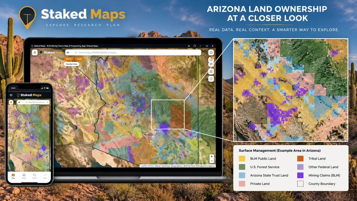
Staked Maps surface-management layer over Arizona, showing BLM public land, U.S. Forest Service land, Arizona State Trust Land, tribal land, other federal land and private land alongside current mining claims.
Does BLM Land Mean You Can Stake a Mining Claim in Arizona?
Not automatically.
A BLM surface-management label does not by itself prove that the mineral estate is federally owned and open to mineral entry.
Under federal mining law, a mining claim may only be located where the relevant public-domain minerals are open to mineral entry. Withdrawals, acquired mineral estates, existing rights and other federal designations can change what is available.
This is also why surface ownership and mineral ownership should not be treated as the same thing. BLM may administer mineral records on lands whose surface is managed by another federal agency, including National Forest System lands.
Use the map to research. Use official records to verify.
Staked Maps helps you see recorded claim activity and land context in one place. It does not make a legal determination that a parcel is open to mineral entry, available for claim location, accessible across surrounding property, or free of other rights and restrictions.
Arizona Gold Prospecting & Rockhounding Rules You Need to Know
Rules depend on the land manager, mineral status, location and level of disturbance. The following is a research starting point, not blanket permission to work any mapped parcel.
Activity / Land Situation
Research Starting Point
Hand panning on eligible BLM land
BLM generally treats hand panning that causes no or negligible disturbance as casual use, subject to local restrictions and land status.
Hand-tool mineral collecting
BLM generally considers hand-tool collection causing negligible disturbance casual use where collecting is otherwise allowed.
Metal detecting
Can fall within casual use on eligible BLM land, but location-specific restrictions still apply.
Mechanized or greater-disturbance activity
Do not assume casual-use rules apply. Contact the responsible land-management office and determine whether a notice, plan or other authorization is required.
Recreational rock/mineral collecting on eligible Arizona BLM land
Current BLM Arizona guidance allows reasonable noncommercial personal-use collecting where not otherwise restricted.
Existing mining claim
A claim on the map is a warning that mineral rights may already be asserted. Do not assume recreational mineral collecting is permitted.
Arizona State Trust Land
Recreational access rules are different, and a recreational permit is not permission to collect minerals or prospect.
Withdrawn, protected or specially managed land
May be closed or restricted regardless of apparent public surface ownership.
Private land
Obtain permission from the landowner and separately confirm mineral rights if mineral activity is involved.
BLM's current Arizona rockhounding guidance sets a general personal-use limit of up to 25 pounds per day and 250 pounds per person per year for qualifying rocks, mineral specimens and semiprecious gemstones on eligible BLM lands. Collection must be noncommercial, and additional restrictions apply in protected, developed or otherwise closed areas.
Rules can change and individual locations can have additional restrictions. Verify the responsible agency's current rules before collecting.
A Verified Arizona Rockhounding Example: Black Hills
One useful example of the difference between a documented mineral occurrence and a verified collecting location is the Black Hills Rockhound Area north of Safford.
BLM specifically manages this area for rock collecting, with fire agate as the primary attraction. BLM currently states that the site is open for public digging without a fee or permit, subject to applicable collecting rules.
That is different from a point in the USGS Mineral Resources Data System. An MRDS point tells you that a mineral occurrence, prospect or mine was documented there. It does not by itself tell you that recreational collecting is legal today.
Regulatory content last reviewed September 14, 2026. This date reflects when Staked Maps last checked these sources — it is not updated automatically with each build.
Arizona Mineral Occurrences & Rockhounding Research
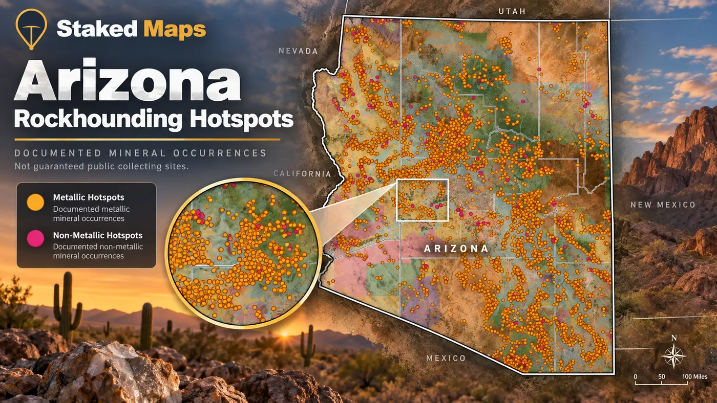
Staked Maps currently contains 10,208 documented Arizona mineral-occurrence records derived from the USGS Mineral Resources Data System. These records can help identify areas where minerals, prospects or mines have been documented historically.
They are research leads, not access permissions.
A Mineral Occurrence Is Not Permission to Collect
An MRDS record may represent a mineral occurrence, prospect, mine or reported commodity. It does not establish current public access, permission to collect, the presence of collectible material today, current mining-claim status or whether the land is subject to restrictions.
Always combine mineral-occurrence research with current claim and land-status research.
Staked Maps Rockhound Hotspots layer over Arizona. Gold: documented metallic mineral occurrences. Pink: documented non-metallic mineral occurrences. These are documented occurrences, not guaranteed public collecting sites.
Source records sometimes use broad or overlapping commodity labels; counts above preserve the underlying record classifications.
Most Common Reported Materials in the Arizona Dataset
Material
Sites Recorded
Gemstone, Semiprecious
33
Quartz
28
Gemstone
24
Kyanite
23
Silica
15
Feldspar
13
How Arizona's Mining History Shaped Today's Claim Map
Arizona's current federal claim map sits on top of more than a century of documented mineral exploration. USGS research identified 87 placer districts in Arizona and estimated approximately 564,000 ounces of placer gold production between 1774 and 1968.
Many of the state's major placer districts occur in the Bradshaw Mountains of central Arizona, where erosion moved gold from mineralized source rocks into stream gravels. Other placer districts developed in the drier mountain ranges and alluvial systems of western and southern Arizona.
Hard-rock development followed a different pattern. Arizona's mining history includes gold districts such as Oatman as well as enormous copper-related mineral systems across the state's broader metallic mineral belt. Over time, that combination produced a landscape containing placer workings, lode mines, prospects, mineral occurrences and modern federal claim records.
Historical production is useful context, but it is not a modern access map. A historically productive district can be heavily claimed, withdrawn, privately owned or otherwise restricted today.
That is why Staked Maps treats historical claims, current claims, mineral occurrences and land ownership as separate research layers instead of treating historic mining locations as automatic prospecting destinations.
Arizona Current vs Historical Mining Claims
Staked Maps' current-vs-historical claim layer for Arizona. Purple: current claims. Pink: historical/closed claims.
A useful mining map needs more than a large number of points and polygons. It also needs clear source provenance and an explanation of what each dataset can and cannot establish.
Current Mining Claims & Sites
Current federal mining claim and site records in Staked Maps originate from Bureau of Land Management mineral-record data, including the Mineral & Land Records System. Staked Maps processes those source records into mapping and research layers and synchronizes the production dataset on a recurring schedule.
Current / not-closed is a Staked Maps grouping. Individual BLM status values are retained separately and are shown in the status analysis above.
Historical / Closed Claims
Historical records represent claims and sites that are part of the closed/historical side of the Staked Maps dataset. They remain useful because previous claim activity can reveal where mineral exploration occurred, but a historical claim does not prove that the land is open today or that economically valuable minerals remain.
Mapped Claim Geometry
Staked Maps converts available federal land descriptions and source geometry into map features designed for research and field reference.
Mapped claim polygons are not professional cadastral surveys and should not be treated as legal property-boundary determinations. Where exact legal position matters, review the official record, land description, survey information and other authoritative documentation.
Surface Management & Land Ownership
Land-ownership and surface-management layers help users understand who manages the surface, but surface management alone does not determine mineral ownership or whether land is open to mineral entry.
This distinction is especially important in Arizona because federal land, National Forest System land, Arizona State Trust Land, private land, tribal land and other designations can occur near one another.
Mineral Occurrences
Staked Maps' mineral-occurrence research layer is derived from the USGS Mineral Resources Data System. MRDS records document mineral occurrences, prospects, mines and reported commodities.
They are not a curated list of legally accessible public rockhounding sites.
Arizona Geology
Arizona-specific geological context on this page relies primarily on authoritative work from the U.S. Geological Survey and Arizona Geological Survey. These sources document Arizona's placer districts, mineral belts, historic mining districts and mineral-resource geology.
Geological information is provided as research context. It is not a prediction that a particular parcel contains economically recoverable minerals.
What Staked Maps Does Not Determine
Staked Maps does not determine:
whether land is legally open to mineral entry
whether a valid mineral discovery exists
mineral value or recoverability
legal mineral ownership
survey-grade claim boundaries
legal access through private property
permission to work another person's mining claim
whether a specific activity requires agency authorization
whether a USGS MRDS location is publicly accessible
whether minerals remain at a historical occurrence
whether an agency restriction changed after source data was published
Staked Maps is a research and navigation tool. For legal filings and final land-status decisions, verify the current official record with the responsible government agency.
Use for: Primary-source historical research on Arizona's documented placer districts.
Frequently Asked Questions
Where does Staked Maps get its mining claim data?
Directly from the Bureau of Land Management's official MLRS (Mineral & Land Records System) case-recordation records, synced into our database on a regular schedule — not scraped or crowd-sourced.
How many active mining claims are in Arizona?
As of September 22, 2026, BLM records in Staked Maps show 54,587 Arizona mining claim and site records with a case disposition of Active. Another 952 are Under Review and 9,947 are Filed, bringing Arizona's total current/not-closed federal claim and site records to 65,486. These database statuses are not a legal determination that an individual claim contains a valid mineral discovery.
What are Rockhound Hotspots?
A premium map layer of documented mineral occurrences, prospects and mines sourced from USGS MRDS and labeled by material where available. These records are research leads, not a directory of verified public collecting sites.
Where are most mining claims in Arizona?
Arizona's current federal mining-claim records are concentrated in a handful of counties. As of the data date above, Yavapai County ranks first, followed by Mohave County and Pinal County. Together, those counties account for about 46% of Arizona's current mapped claim/site records. Claim concentration indicates recorded mining activity, not whether adjacent land is open for prospecting or whether it has mineral potential.
Does the Arizona map cover the whole state?
Yes. Staked Maps covers Arizona statewide. Dedicated research pages are currently available for Yavapai County, Mohave County, La Paz County, Cochise County and Pinal County, while the interactive map covers claims and surface management throughout Arizona.
Which agency manages federal mining claims in Arizona?
The Bureau of Land Management manages federal mining-claim records through the Mineral & Land Records System and the applicable BLM offices. Arizona county recording requirements and other state or local requirements may also apply when locating and maintaining claims.
What's the difference between current and Active mining claims?
"Current / not-closed" is a Staked Maps grouping for records that are not in the historical/closed portion of the dataset. "Active" is a specific BLM status value. Because current records can contain more than one BLM status, the complete current total and the Active-status total are not necessarily the same number.
What's the difference between a current and historical mining claim?
Current/not-closed records are on the current side of the Staked Maps federal-record dataset. Historical or closed records represent previous claim or site activity that is no longer included in that current grouping. Historical records can be useful for researching previous mineral activity, but they do not prove that land is now open to claim or prospect.
Can I prospect on BLM land in Arizona?
Sometimes, but BLM surface management alone is not blanket permission to prospect. The mineral estate must be eligible for the activity, the location must not be closed or otherwise restricted, existing mining rights must be respected, and the level of disturbance can affect what authorization is required. BLM generally treats activities such as hand panning and hand-tool collection causing negligible disturbance as casual use on eligible lands, subject to location-specific rules.
If no mining claim appears on the map, can I stake one there?
Not automatically. An area with no current claim displayed may still be unavailable because of mineral ownership, withdrawals, acquired lands, existing rights or other restrictions. A blank area on a mining-claim map should be treated as a place to investigate further, not proof of open ground.
Can I prospect or metal detect on Arizona State Trust Land?
Do not treat Arizona State Trust Land like ordinary BLM public land. Arizona's recreational permit authorizes limited recreational uses, but it is not a mineral-exploration permit and does not authorize recreational removal of natural products. Mineral exploration on State Trust Land uses a separate Arizona State Land Department permitting process. Check current State Land Department rules for the specific parcel and activity.
Can I collect rocks and gemstones on Arizona BLM land?
BLM generally allows reasonable noncommercial personal-use collecting of qualifying rocks, mineral specimens and semiprecious gemstones on eligible public lands where collecting is not otherwise restricted. Current Arizona BLM guidance generally limits qualifying personal-use collection to 25 pounds per day and 250 pounds per person per year. Developed sites, protected areas and other locations can have additional restrictions, so check the responsible BLM office before collecting.
Are all Staked Maps mineral-occurrence locations open to collecting?
No. A mineral-occurrence record tells you that mineral activity or a commodity was documented at or near that location. It does not establish public access, current mineral ownership, permission to collect, claim status or whether collectible material remains.
Can I search Arizona mining claims by claim number?
Paid Staked Maps plans include claim-number search and additional claim details. Free users can explore the Arizona map and use the features included with the free plan.
Are Staked Maps mining-claim polygons legal property boundaries?
No. Staked Maps claim geometry is designed for research and field reference and should not be treated as a professional cadastral survey or legal boundary determination. Review official BLM records, land descriptions and appropriate survey information when exact legal position matters.
Arizona's mining history is extensive, but useful field research depends on today's records. Current claims, historical activity, land ownership, mineral occurrences and access restrictions all answer different parts of the same question.
Staked Maps brings those research layers together so you can narrow an area before driving into the desert or backcountry. Official BLM and Arizona records remain the final source for legal status, filings and permissions.
Single State, Tri-State and All-West all unlock the exact same features — nothing is pay-gated between them, they differ only in how many states you get.
Paid plans renew automatically at the monthly or annual rate you choose until you cancel. Cancel anytime and keep access through the end of your paid period. See our Terms of Use.
Single State, Tri-State and All-West unlock the identical feature set — only the number of states differs.
National Rockhound Pass is a separate, nationwide-but-lighter product built for rockhounds outside the core mining states.
Free
Single State
Tri-State
All-West
Rockhound Pass
Geographic coverage
1 state (view only)
1 state, full data
3 states, full data
13 Western states, full data
All 50 states, safety layer only
Interactive claims map, basemaps, compass, county search
✓
✓
✓
✓
✓
Surface management (public/private land) overlay
✓
✓
✓
✓
✓
Claim type, name, status & size in popups
✓
✓
✓
✓
✓
Full legal location (aliquot description)
✕
✓
✓
✓
✕
Claim serial number, owner intel, BLM Records & 'Directions' button
✕
✓
✓
✓
✕
Search by claim number
✕
✓
✓
✓
✕
Custom pins & distance measure tool
✕
✓ (up to 50)
✓ (up to 50)
✓ (up to 50)
✓
Expired & historical claims layer
✕
✓
✓
✓
✕
Placer/Lode claim filters & latest synchronized data
Information hosted on Staked Maps is compiled from publicly available data
streams provided by the Bureau of Land Management (BLM) and relevant state
geographic clearinghouses. Staked Maps accepts no liability for the content of
this geospatial data, or for the consequences of any real-world exploration,
land entry, or staking actions taken on the basis of the information provided
via this application interface.
Staked Maps makes no warranty, expressed or implied, including the warranties of
merchantability and fitness for a particular purpose, nor assumes any legal
liability or responsibility for the pinpoint accuracy, reliability, completeness,
latency, or programmatic utility of these geospatial data layers, or for the
improper interpretation of these data grids.
These mapping layers and related graphics are visual convenience aids only; they
are not legal documents and must never be used as such. The data may not be used
to legally determine title, mineral ownership, valid description boundaries,
jurisdictional authorities, or land restrictions in place on public or private
land. Natural backcountry hazards may or may not be depicted on topographies, and
land users are strictly mandated to exercise caution. Federal records are dynamic
and change constantly. The end-user is exclusively responsible for validating
current land classifications with local BLM field offices and managing compliance
accordingly.