Utah Mining Claims Map: Current BLM Claims, Land Status & Rockhounding
Research Utah mining claims with current federal claim data, historical claim context, land-status mapping, and mineral occurrence research tools. Staked Maps helps prospectors and rockhounds explore recorded claim activity across Utah while checking the map context that matters before heading into the field.
Free account · No credit card required · Opens directly to the Utah map
Current Utah claims shown with the surface-management layer in Staked Maps.
Utah Mining Claims at a Glance
43,423
Current / Not-Closed Claim & Site Records
18,162
BLM Disposition: Active
447,334
Historical Claim Records
3,706
Documented Mineral-Occurrence Records
This is the quick read on Utah’s federal claim picture as of October 1, 2026. Utah has substantial current mining claim activity spread across multiple regions, but claim distribution is not uniform. Some areas remain highly concentrated while others show broad historical activity with relatively less current claim density. That is where a visual research tool is more useful than raw tables alone.
Mining claim data synchronized: . BLM MLRS records are synchronized with Staked Maps on a regular schedule, not live with every page visit. Mineral-occurrence records come from the Utah Geological Survey’s UMOS database.
Where Are Utah’s Current Mining Claims Concentrated?
Utah’s current claim activity is not spread evenly across its 29 counties. The table ranks the five counties with the most current/not-closed federal claim and site records. Together, San Juan County, Beaver County and Grand County hold 38.9% of Utah’s 43,423 current records.
County counts come from matching each record’s mapped location to U.S. Census county boundaries. 72 current Utah records (0.2%) could not be assigned to a county. They are still counted in the statewide total.
Utah’s mining claims are concentrated in a limited number of counties rather than evenly spread across the state. The high-count counties show where modern claim activity remains strongest, and the lode/placer mix says something about its character. Among counties with at least 1,000 current records, Grand County (82.2% placer) and Box Elder County (56.0% placer) lean most toward placer claims, while Piute County (99.3% lode) and Iron County (98.3% lode) are the most lode-heavy. Those county percentages are shares of each county’s lode plus placer records, leaving out mill and tunnel sites. Statewide, lode claims are 67.7% and placer claims 31.3% of all current records.
This table is meant to help you spot regional patterns. It does not determine whether any specific tract is open to location.
BLM records four kinds of locatable-mineral cases: lode claims, placer claims, mill sites and tunnel sites. Here is how Utah’s current/not-closed records divide among them.
Record Type
Current Records
Share
Lode claim
29,378
67.7%
Placer claim
13,590
31.3%
Mill site
443
1.0%
Tunnel site
12
<0.1%
Utah’s current records are dominated by lode claims, with placer claims also making up a substantial share. Mill and tunnel sites are a much smaller part of the statewide total, but they still add context when you review how claim activity is distributed. Claim type does not identify the commodity being sought. See BLM’s mining claims overview for how each type is defined.
Utah BLM Status Breakdown
“Current” and “active” are not interchangeable, and Utah shows why. In Staked Maps, “current” refers to federal claim records that are not shown as closed, while BLM’s Active disposition is a narrower subset. Right now BLM labels 18,162 (41.8%) of Utah’s current records Active and 25,089 (57.8%) Filed, with the rest under other statuses.
BLM Status
Records
Share of Current Records
Active
18,162
41.8%
Filed
25,089
57.8%
Under Review
149
0.3%
On Appeal
12
<0.1%
Draft
11
<0.1%
Total Current / Not-Closed
43,423
100%
A current-looking record is not always the same thing as a fully active one. These are BLM administrative case-disposition labels, not a Staked Maps judgment of claim validity or ownership. Check the most current official status in BLM MLRS before making a decision that depends on it.
See where Utah's current claim records are located
Open the free Utah map to inspect recorded claims alongside surface-management boundaries.
No Current Claim Does Not Mean Open Ground in Utah
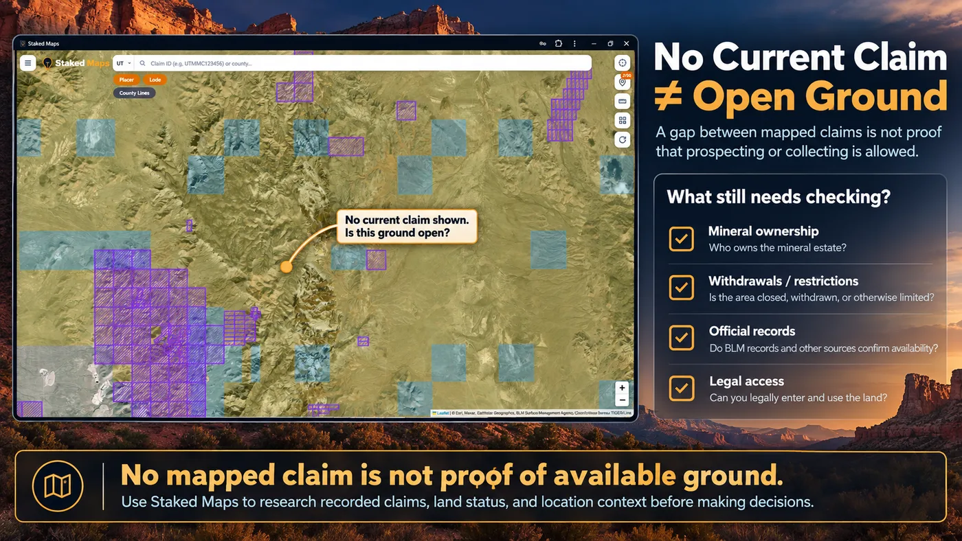
A visible gap between mapped current claims is not automatic proof that the ground is open to mineral entry, prospecting or collecting. In Utah, you may still need to check mineral ownership, surface ownership, land withdrawals, agency restrictions and access limitations before assuming an area is available.
Utah’s older mining districts add a specific complication. Some historically claimed ground there has passed into patented ownership, and patented ground does not appear as a current federal claim. This is one of the most important reasons to use a research map rather than a simple claim list: a map gap can be the start of an investigation, not the end of it.
A mapped gap between current claims is not proof that the area is open. Additional land-status and ownership research may still be necessary.
What still needs checking?
Mineral ownership. The surface owner and the mineral owner can differ.
Withdrawals or restrictions. Some federal land is closed to mineral entry even with no claim on it.
Official records. Confirm status in BLM MLRS and county records, not the map alone.
Legal access. Being able to see ground on a map does not mean you can legally reach it.
Utah land research can be especially confusing because not all state-managed land is the same. Utah Trust Lands are administered separately, by the Trust Lands Administration, and can involve different surface and mineral ownership questions than nearby BLM-managed public land. Other state-managed land exists too, so not every parcel that looks like “state land” is trust land. Users who assume that all state land, or all apparently open ground, works like ordinary BLM public land can easily make mistakes.
That distinction matters for prospectors, rockhounds and anyone researching land access. Surface ownership does not automatically establish mineral ownership, and neither one by itself confirms that prospecting or collecting is allowed.
Official ownership maps
View Utah’s Official Trust Lands Ownership Maps
The Utah Trust Lands Administration provides official downloadable maps showing statewide and county-level trust land surface and mineral ownership information.
These official maps are provided by the Utah Trust Lands Administration and are useful for ownership research. They should be used alongside current claim and land-status research, not as a substitute for it.
Topaz Mountain: Why Checking the Map Matters
Topaz Mountain, in Juab County, shows why a known mineral occurrence and permission to collect are two separate questions.
The Utah Geological Survey’s collecting guide identifies a mixture of BLM public land, School Trust Land and possible gemstone leases in the area. It also cautions visitors not to collect on marked claims.
That is why an area that looks open on a mining claim map deserves more investigation. Before collecting, verify current surface and mineral ownership, existing claims or leases, the collecting rules that apply and legal access.
Staked Maps helps you examine recorded federal claim activity and the surrounding surface-management context. It does not replace official ownership, lease or authorization records.
What Do Utah’s Historical Mining Claims Tell You?
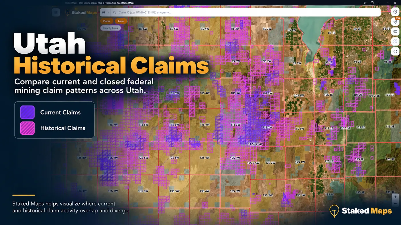
Historical claim patterns help show where mining activity has been concentrated over time, even where current claim density now looks lighter. Utah has 447,334 historical/closed claim records in Staked Maps, about 10 for every current record. Those patterns often reflect long-running mining districts, changing commodity interest, and areas that stay relevant for research even after current activity has shifted.
This map compares current and historical claim patterns, helping visualize where recorded mining activity has persisted or changed over time.
Historical claims do not establish present-day availability, but they provide context. Areas with dense historical activity may still deserve closer research, because past mining often points to geologic interest, prior development or long-term claim turnover. They do not prove minerals remain or that old workings are safe; see Abandoned Mines and Historical Mining Claims.
Utah’s Historical Mining Districts Still Matter
Utah’s mining history is tied to a handful of long-running districts. The Utah Geological Survey lists Bingham Canyon, Tintic, Park City, Iron Springs, Lisbon Valley, Mercur and Spor Mountain among the state’s major metal-mining districts. Bingham Canyon alone has produced about 80 percent of Utah’s total historical metal production value. Mercur, on the southwestern flank of the Oquirrh Mountains, was Utah’s top gold camp.
For anyone researching Utah claims, that history is more than background reading. It helps explain why some areas show layer after layer of historical claims, why some regions are still claim-dense, and why a district may matter even when a single parcel looks quiet at first glance. In older mining districts, some historically claimed ground has passed into patented ownership and no longer appears in the current federal mining claim dataset. An area without a mapped current claim may therefore require additional ownership and mineral-title research. The absence of a current claim record does not establish whether the ground is available for new location.
Why this matters
It explains long-term mining activity in an area.
It gives context for where claims cluster today.
It connects historical records to modern claim research.
Utah Rockhounding: Mineral Occurrences vs. Collecting Access
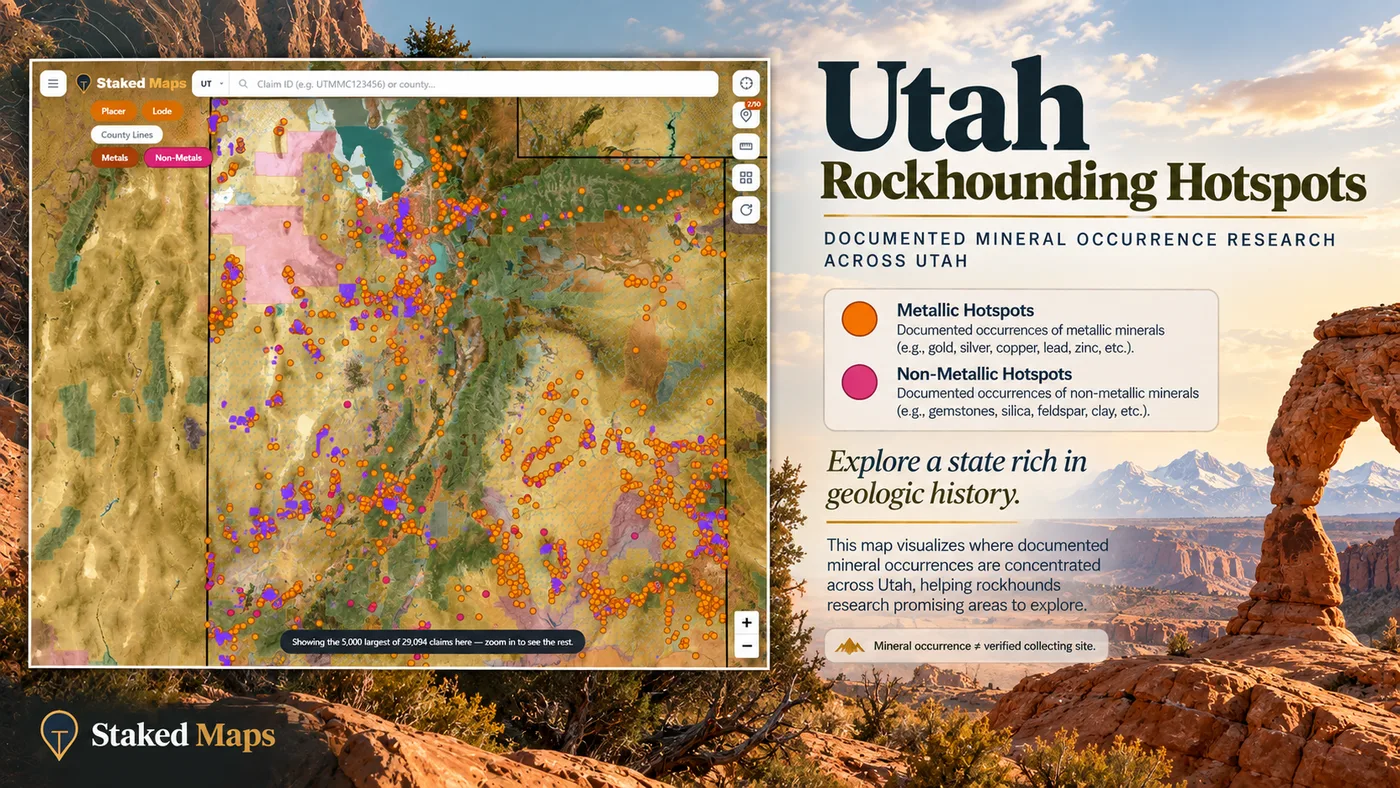
Utah draws a lot of rockhounding interest, but documented mineral occurrences should not be confused with verified public collecting sites. Mineral occurrence data shows where minerals have been documented. Actual collecting permission depends on land ownership, regulations, claim status and access rules.
Staked Maps’ Utah layer has 3,706 records drawn from the Utah Geological Survey’s Utah Mineral Occurrence System (UMOS), a database of mineral occurrences, prospects, mines and mineral resources. Most of them are metal occurrences, which tells you a record is usually a mine or prospect site, not a gem field.
The map legend groups these records as Metals and Non-Metals. In Utah’s data, the Non-Metals group means something narrower than every non-metallic mineral: it holds only UMOS records that list a gem or lapidary material, such as variscite, jasper, chalcedony, geodes or topaz. 4 of those 38 records also list a metal. Industrial non-metallic commodities in UMOS, such as sand and gravel, quartzite, potash and tar sand, are left out of the layer entirely, so these figures are not a count of all non-metallic mineral occurrences in Utah.
3,668
Metallic records
99.0%
38
Non-metallic (gem / lapidary) records
1.0%
This map highlights documented mineral occurrence research across Utah. A mineral occurrence is not the same thing as a verified collecting site.
Use this layer to explore Utah’s broader areas of geologic interest and to ask better research questions. It does not mean every mapped occurrence is open for casual collection.
How to Use Staked Maps for Utah Mining Claim Research
A practical order of operations for a Utah area you are curious about:
Step 1
Review current claim activity
See which current federal claim records sit in and around your area of interest.
Step 2
Compare current and historical patterns
Turn on historical claims to see where past activity extends beyond today’s records.
Step 3
Check surface-management context
Identify BLM, Forest Service, state and other managed land. Surface management alone does not settle mineral ownership.
Step 4
Narrow the location with PLSS
Use township, range and section to match the area to the way public land records describe it.
Step 5
Investigate what else may apply
Check ownership, withdrawals, Trust Lands status and legal access before treating ground as available.
Staked Maps puts these overlapping layers in one place, so it is easier to spot patterns and ask better research questions before heading into the field. Current claims and surface management are on the free map; historical claims, PLSS, full claim details and offline maps come with the paid mining plans.
Research Utah Claims in Staked Maps
Whether you are prospecting, checking claim activity, or researching Utah land status for rockhounding, Staked Maps helps you move beyond raw claim lists and understand the map context that matters.
As of October 1, 2026, Staked Maps has 43,423 current/not-closed federal mining claim and site records for Utah, plus 447,334 historical/closed records. Of the current records, BLM labels 18,162 Active and 25,089 Filed, with a smaller number under other statuses. Totals change over time as BLM records are updated.
What is the difference between current and historical mining claims in Utah?
Current claims are records that are not shown as closed, while historical claims are past records that no longer appear as current. Historical activity can provide useful context, but it does not determine whether land is open today.
Does no current claim mean the land is open in Utah?
No. A gap between mapped current claims is not automatic proof that the ground is open. Mineral ownership, land withdrawals, official records and legal access may still need to be checked. In older Utah districts, some historically claimed ground has passed into patented ownership and no longer appears as a current federal claim, so an unclaimed-looking area may need ownership and mineral-title research.
Are Utah Trust Lands the same as BLM public land?
No. Utah Trust Lands are administered separately, by the Utah Trust Lands Administration, and should not be treated as the same as BLM-managed public land. The Trust Lands Administration publishes official surface and mineral ownership maps.
Can I use Staked Maps for Utah rockhounding research?
Yes, as a research tool. Staked Maps can help you explore mineral occurrence patterns from the Utah Geological Survey’s UMOS database alongside land context, but you still need to verify access, regulations and current land status before collecting.
What do historical mining claims tell you?
Historical claims can show where mining activity has occurred over time and help identify long-running areas of mineral interest, but they do not by themselves establish current availability.
Does surface management determine whether prospecting is allowed?
Not by itself. Surface management is important context, but it does not automatically determine mineral ownership or whether prospecting or collecting is permitted.
What is the best way to research Utah mining claims?
Use current claim data, historical context, land-status mapping, ownership research and official agency information together rather than relying on a single map layer or claim list.
What Premium Adds to Your Utah Map
Historical Claims. See where mining activity existed before today's current records.
Full Claim Details. Serial number, legal location information and a direct path back to the official BLM record.
Research Layers. PLSS, roads/trails, waterways and Utah mineral occurrences.
Offline Maps. Save your Utah research before losing cell service.
Field Tools. Directions, custom pins, measurements and claim-drafting tools.
Single State unlocks all premium features for Utah for $29.99/year.
Plans
Choose Your Plan
Basic
Free
Try Staked Maps in one state.
$0/mo
✓Interactive mining claims map — pick your state (or use your location)
✓Surface management overlays & current mining claims
✓Claim type, name, status & size in claim popups
Paid plans unlock full claim details, historical claims, research layers and offline tools.
Single State, Tri-State and All-West all unlock the exact same features — nothing is pay-gated between them, they differ only in how many states you get.
Paid plans renew automatically at the monthly or annual rate you choose until you cancel. Cancel anytime and keep access through the end of your paid period. See our Terms of Use.
Single State, Tri-State and All-West unlock the identical feature set — only the number of states differs.
National Rockhound Pass is a separate, nationwide-but-lighter product built for rockhounds outside the core mining states.
Free
Single State
Tri-State
All-West
Rockhound Pass
Geographic coverage
1 state (view only)
1 state, full data
3 states, full data
13 Western states, full data
All 50 states, safety layer only
Interactive claims map, basemaps, compass, county search
✓
✓
✓
✓
✓
Surface management (public/private land) overlay
✓
✓
✓
✓
✓
Claim type, name, status & size in popups
✓
✓
✓
✓
✓
Full legal location (aliquot description)
✕
✓
✓
✓
✕
Claim serial number, owner intel, BLM Records & 'Directions' button
✕
✓
✓
✓
✕
Search by claim number
✕
✓
✓
✓
✕
Custom pins & distance measure tool
✕
✓ (up to 50)
✓ (up to 50)
✓ (up to 50)
✓
Expired & historical claims layer
✕
✓
✓
✓
✕
Placer/Lode claim filters & latest synchronized data
Staked Maps processes publicly available Bureau of Land Management claim records and synchronizes them into a map designed for field research. It is not a substitute for the official record.
Current/not-closed records: Federal mining claim and site records come from the Bureau of Land Management’s Mineral & Land Records System (MLRS). Staked Maps synchronizes those records into its research database; a record remains in the current/not-closed dataset until it is marked closed through that process.
BLM disposition: Retained separately as source data from BLM (Active, Filed, Under Review, On Appeal or any other status present). BLM case-type values are normalized into Lode, Placer, Mill Site and Tunnel Site.
Historical claims: Sourced from BLM’s historical/closed-claims layer. Staked Maps does not represent its local historical cache as a complete archival mirror of every BLM record.
Sync schedule: Nightly incremental sync, a weekly full reconciliation, and a monthly cross-check against BLM’s closed-claims layer.
Claim geometry: Claim polygons are research approximations derived from recorded legal land descriptions under the Public Land Survey System. Most come from BLM’s own approximation of the legal description at aliquot or section resolution; where BLM supplies no polygon, Staked Maps draws an approximate rectangle from the legal description. They are not professional land surveys and should not be treated as exact surveyed claim boundaries.
Counties: County assignment is a spatial match against U.S. Census county boundaries, not a county field supplied by BLM. 72 Utah current records could not be assigned to a county; they are still counted in statewide totals.
Rockhound / mineral data: Sourced from Utah Geological Survey, Utah Mineral Occurrence System (UMOS). Utah mineral-occurrence records are derived from the Utah Geological Survey’s UMOS database. Records listing a gem or lapidary material are grouped as non-metallic; other kept records list a metal. Industrial non-metallic commodities such as sand and gravel are excluded. These are occurrence, prospect and mine research records, not verified public collecting sites.
Land / PLSS: The Surface Management Agency layer is based on BLM’s official SMA service. SMA colors describe surface management. They do not, by themselves, establish mineral ownership, mineral-entry status or permission to prospect.
Limitations: For legal filings, boundary-sensitive decisions or questions about whether land is open to mineral entry, verify the official record and applicable agency requirements.
Information hosted on Staked Maps is compiled from publicly available data
streams provided by the Bureau of Land Management (BLM) and relevant state
geographic clearinghouses. Staked Maps accepts no liability for the content of
this geospatial data, or for the consequences of any real-world exploration,
land entry, or staking actions taken on the basis of the information provided
via this application interface.
Staked Maps makes no warranty, expressed or implied, including the warranties of
merchantability and fitness for a particular purpose, nor assumes any legal
liability or responsibility for the pinpoint accuracy, reliability, completeness,
latency, or programmatic utility of these geospatial data layers, or for the
improper interpretation of these data grids.
These mapping layers and related graphics are visual convenience aids only; they
are not legal documents and must never be used as such. The data may not be used
to legally determine title, mineral ownership, valid description boundaries,
jurisdictional authorities, or land restrictions in place on public or private
land. Natural backcountry hazards may or may not be depicted on topographies, and
land users are strictly mandated to exercise caution. Federal records are dynamic
and change constantly. The end-user is exclusively responsible for validating
current land classifications with the BLM Utah State Office, the county recorder, or the Utah Trust Lands Administration for trust land and managing compliance
accordingly.