
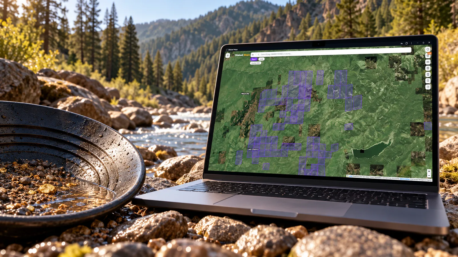
You've found a California gold district with real history behind it. A Gold Rush town, a river with placer gravels, maybe a few old mine names. The next question is harder: can you actually work that ground, and is anyone already holding it?
The quick answer: in California, four separate checks decide that, and none of them stands in for another.
- Current federal mining claims. BLM's claim records tell you whether someone holds an unpatented claim there now.
- Who manages the surface. Large parts of California's historic gold regions are National Forest land, where Forest Service rules for mining operations apply, not BLM's. Much of the rest is private, often old patented mining ground.
- Withdrawals. Some federal land is closed to new claims. Other land carries a withdrawal that still allows claims under special conditions, and California's gold rivers are full of those.
- California's own rules. Motorized suction dredging is banned statewide, and work that changes a streambed can require notice to the California Department of Fish and Wildlife (CDFW), whoever owns the land.
A blank spot between claims on a map doesn't settle any of the four. The rest of this guide shows where California's placer claims actually are, how each check works, and a full worked example in the Downieville district of Sierra County.
California's Biggest Placer Claim County Isn't in Gold Country
As of October 28, 2026, Staked Maps tracks 11,402 current (not closed) federal placer claims in California, out of 29,258 current claim and site records statewide. Here are the ten counties with the most placer claims:
| County | Current placer claims | Current lode claims | What kind of ground |
|---|---|---|---|
| San Bernardino | 4,633 | 6,763 | Mojave Desert, including dry lakebeds |
| Sierra | 918 | 336 | Northern Sierra Nevada gold region |
| Siskiyou | 726 | 264 | Klamath Mountains gold region |
| Nevada | 675 | 88 | Northern Sierra Nevada gold region |
| Plumas | 614 | 875 | Northern Sierra Nevada gold region |
| Imperial | 512 | 1,190 | Colorado Desert |
| Inyo | 403 | 2,178 | Eastern California desert and ranges |
| Kern | 387 | 838 | Mojave Desert and southern Sierra |
| Placer | 369 | 95 | Northern Sierra Nevada gold region |
| Trinity | 302 | 66 | Klamath Mountains gold region |
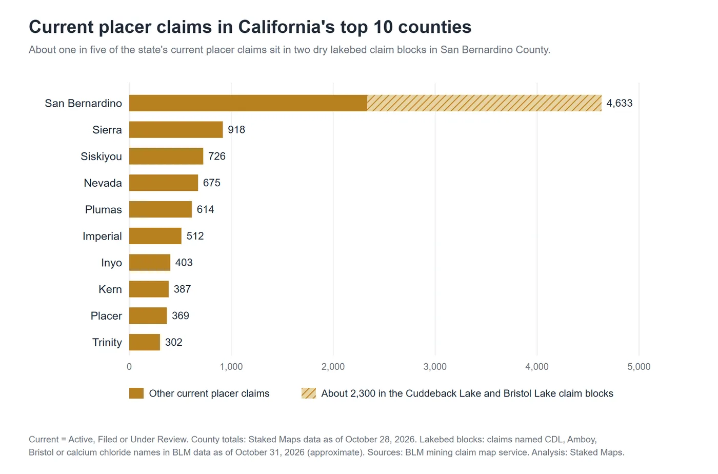
San Bernardino County holds more placer claims than the next four counties combined, and it sits in the Mojave Desert. "Gold Country" usually means the Sierra Nevada foothills, the belt of the 1849 Gold Rush. In this guide, the Sierra Nevada counties and the Klamath Mountains counties of Siskiyou and Trinity, California's other major historic gold region, are called the gold regions. San Bernardino's lead doesn't make it California's best placer gold county, and the reason matters for anyone reading a claim map.
A placer claim covers minerals found in loose material: gravels, sands and lakebed sediments. Gold is the classic placer mineral, but it isn't the only one. Two very large claim groups in the Mojave Desert show the difference. In BLM records as of October 31, 2026:
- About 1,600 current placer claims carry the name "CDL" and sit in the townships around Cuddeback Lake, a dry lakebed in San Bernardino County.
- About 600 current placer claims are named "Amboy," with about 70 more named for calcium chloride or Bristol, around Bristol Lake. Bristol Dry Lake's brines have been worked for calcium chloride for over a century, and the U.S. Geological Survey has studied them for lithium as well.
Those two areas alone account for about 2,300 of California's 11,231 current placer claims in BLM's data that day: roughly one in five. A claim name doesn't prove what a claimant is after, but a block of hundreds of claims across a dry lakebed is a very different research situation from a scattering of claims along a Sierra river.
What this means for gold prospectors: a county or statewide placer count can mislead you. For gold, look at the northern Sierra counties (Sierra, Nevada, Plumas, Placer) and the Klamath Mountains (Siskiyou, Trinity). Then look at individual townships and districts, not totals.
Reading Placer and Lode Claims in California's Gold Regions
A lode claim covers minerals in place in solid rock, such as a gold-quartz vein. A placer claim covers minerals in loose deposits, such as river gravels, bench gravels or old Tertiary channel gravels. Each claim type follows its own location rules, and the type tells you what the claimant believes the ground holds.
In California's gold regions, the ratio between the two often tracks real geology:
- Nevada County: 675 current placer claims against 88 lode. That pattern points to river and bench gravel country.
- Plumas County: 614 placer against 875 lode. That's a much more mixed picture.
- One township can hold both. Township 19 North, Range 10 East (Mount Diablo Meridian) in Sierra County includes Goodyears Bar and the Alleghany area. It has 141 current placer claims and 117 current lode claims. Alleghany is historically a lode gold district, so the lode claims there make geological sense.
For placer research, filtering a map to placer claims only removes the lode clutter and shows you where people are actively holding gravel ground. If you're metal detecting rather than staking, the lode claims still matter: a lode claim gives its holder rights to the locatable minerals in the ground it covers.
Where the Forest Service Manages the Surface
Large parts of the Sierra Nevada and Klamath Mountains gold regions are National Forest System land, in forests such as the Tahoe, Plumas, Klamath, Shasta-Trinity, Eldorado and Stanislaus. On those lands, BLM still keeps the official mining claim records, but the Forest Service regulates surface use under 36 CFR Part 228.
The Forest Service rules draw a line based on surface disturbance. Under 36 CFR 228.4(a)(1)(ii), a notice of intent to operate is not required for prospecting and sampling that won't cause significant surface disturbance, which the regulation says generally includes:
- gold panning
- metal detecting
- non-motorized hand sluicing
- battery operated dry washers
- collecting mineral specimens with hand tools
Operations that might cause significant surface disturbance need a notice of intent filed with the District Ranger. Operations likely to cause significant disturbance need an approved plan of operations before work begins. Individual forests can also close specific areas, such as campgrounds, wilderness and developed recreation sites, so check with the ranger district for the ground you're considering.
Two other points apply on National Forest land:
- An existing mining claim still matters. Recreational panning that doesn't count as mining operations under Forest Service rules doesn't override a claimant's rights to the locatable minerals. Prospecting on someone else's claim can lead to a dispute even where the Forest Service wouldn't require any paperwork. See Can You Keep Gold You Pan on BLM Land? for how claims and casual collecting interact.
- The rules may change. On February 20, 2026, the Forest Service published a proposed rule revising 36 CFR Part 228, Subpart A (91 FR 8316). The comment period closed April 21, 2026, and the Forest Service has said it intends to publish a final rule in late 2026. As of October 31, 2026, no final rule had been published, so the current 228.4 language above still applies.
Private land is the other big piece. The Gold Rush produced thousands of patented mining claims, which are now private property. Many sit in the middle of National Forest boundaries, right where the historic mining was richest. Private land isn't open for prospecting without the owner's permission, whatever the old mine maps show. For how surface ownership and mineral ownership can split, see Mineral Rights vs. Mining Claims.
California Rules That Apply on Every Kind of Land
Federal land status is only half of it. California has two state rules that catch many prospectors off guard.
Motorized suction dredging is banned statewide. CDFW states that suction dredging "is currently prohibited and unlawful throughout California," and that CDFW "is also currently prohibited from issuing any permits." The ban comes from Fish and Game Code section 5653.1, which says the use of any motorized vacuum or suction dredge equipment is prohibited in California. SB 637 (effective January 1, 2016) defines suction dredging as a mechanized or motorized system for removing material from the bed, bank or channel of a river, stream or lake to recover minerals. CDFW notes that the definition doesn't restrict nonmotorized recreational mining such as panning. Because the ban is state law, holding a federal mining claim doesn't exempt you from it.
Streambed work can require notice to CDFW. Under Fish and Game Code section 1602, any person must notify CDFW before an activity that may divert or obstruct the natural flow of a river, stream or lake, change its bed, channel or bank, use material from it, or deposit material into it. CDFW says this covers waterways that are dry for part of the year as well as those that flow year-round. Panning a handful of gravel is not what this rule is aimed at, but moving rocks to build a sluice run, rearranging a channel or working a dry wash on a larger scale can reach it. If you're planning anything beyond a pan and hand tools in or beside a stream, ask the CDFW regional office first.
Withdrawals: Closed Ground, and Ground That Only Looks Closed
A mineral withdrawal is an order or law that removes federal land from some or all of the mining laws. On a map, withdrawals are easy to overread in both directions. Two types come up often in California's gold regions.
Wild and Scenic Rivers. Under the Wild and Scenic Rivers Act (16 U.S.C. 1280), the minerals in federal land within one quarter mile of the bank of a river segment designated as "wild" are withdrawn from appropriation under the mining laws, subject to valid existing rights. Segments classified as scenic or recreational aren't withdrawn by the Act itself, though other restrictions can still apply. Several California rivers have wild segments, so check the classification of the exact stretch you're looking at.
Powersite withdrawals. Starting in the early 1900s, the federal government withdrew land along many western rivers as potential dam and power sites. Some cover long stretches of California's gold rivers, and they look like closures on a withdrawal map. Under a 1955 federal law, though, powersite land is generally open to mining claims, with conditions and exceptions.
The Mining Claims Rights Restoration Act of 1955 (30 U.S.C. 621) opened public lands withdrawn for power development to mining claims, with conditions:
- Placer claims carry a waiting period. The locator "shall conduct no mining operations for a period of sixty days" after filing the notice of location. If the Interior Department notifies the locator within those 60 days that it intends to hold a hearing, operations stay suspended until the hearing ends and an order issues.
- The hearing decides placer mining. It asks whether placer mining "would substantially interfere with other uses of the land." The resulting order can prohibit placer mining entirely, allow it on condition that the surface is restored afterward, or allow it generally.
- Some powersite land stays closed. Land inside a project operating or being built under a Federal Power Act license, or under examination by a holder of a qualifying FERC preliminary permit, isn't opened by the Act.
- Other withdrawals still apply. Under 43 CFR 3732.1, if powersite land is also covered by a different withdrawal that blocks mining, the 1955 Act only opens it to the extent the land is otherwise open.
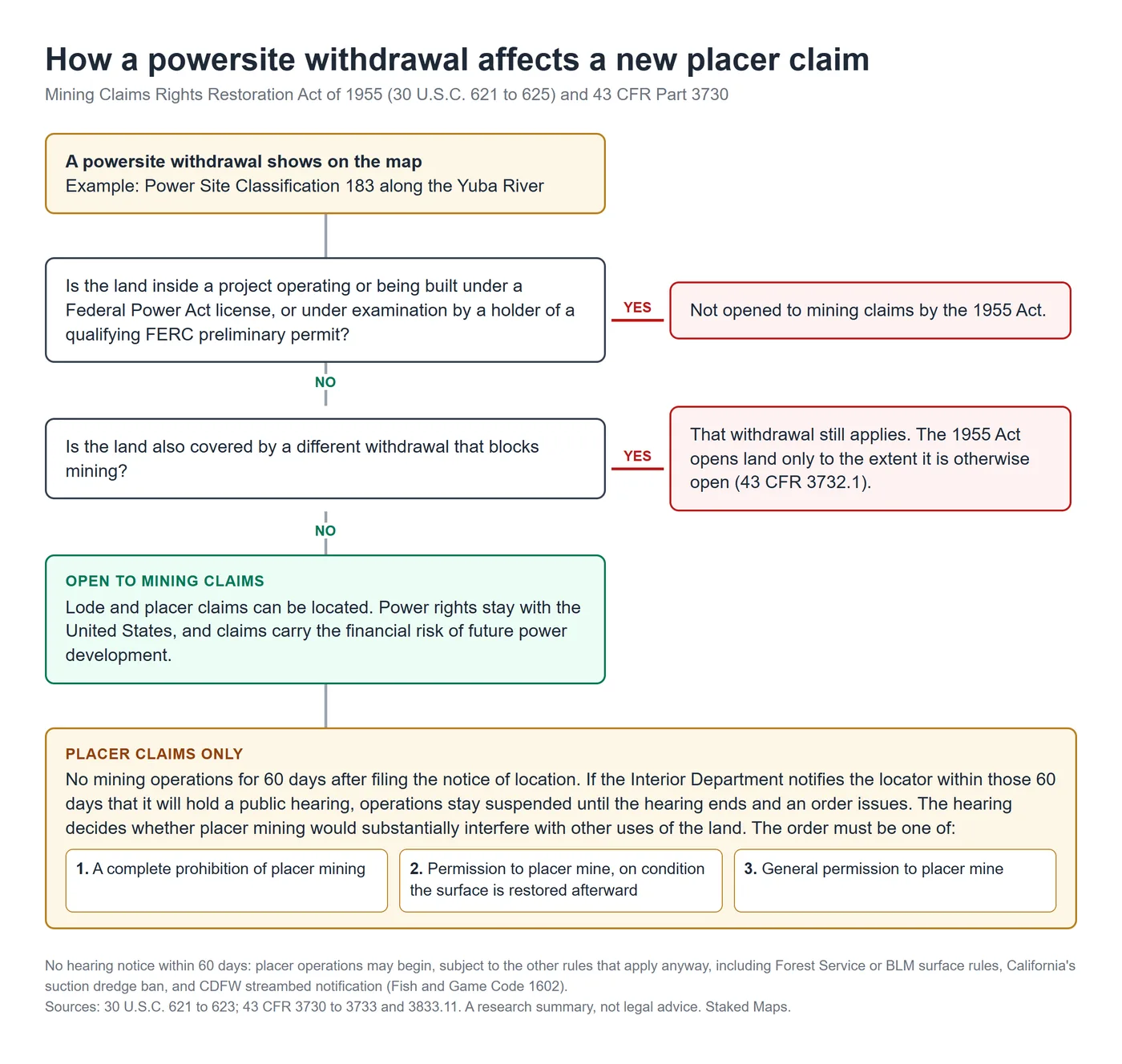
The Downieville example below shows what this looks like on the ground.
Researching One District Step by Step: Downieville
The Downieville district is a documented lode and placer gold district in west-central Sierra County, on the North Yuba River. Here's how to research it with real records. All claim counts are from BLM's mining claim service as of October 31, 2026.
Step 1: Start with documented production, not a list of "hot spots." California Division of Mines and Geology Bulletin 193, Gold Districts of California (W.B. Clark, 1970), describes Downieville as "a lode and placer gold-mining district in west-central Sierra County." It records that a 25-pound nugget was found in the river upstream from town in 1850. After the surface placers were worked out, "the river was mined, and hydraulic and drift mining became important." The bulletin names the district's placer mines, including the White Bear (with recorded production of $200,000+), Wide Awake, Mt. Vernon, Craycroft, City of Six and others. It also notes that the higher ridges are capped by Tertiary andesite that in places overlies rich Tertiary auriferous gravels. That gives you two placer targets: recent river and terrace gravels along the Yuba, and older channel gravels high on the ridges.
Step 2: Put the district in survey terms. The town of Downieville sits in Township 20 North, Range 10 East, Mount Diablo Meridian. Goodyears Bar, just downriver, is in Township 19 North, Range 10 East. Township and range is how BLM records describe claims, so this is the bridge from history to current records.
Step 3: Count current claims by type.
| Township (Mount Diablo Meridian) | Current placer | Current lode | Closed placer | Closed lode |
|---|---|---|---|---|
| T20N R10E (Downieville) | 136 | 54 | 653 | 360 |
| T19N R10E (Goodyears Bar, Alleghany) | 141 | 117 | 953 | 767 |
Both townships are actively claimed. That's normal for a productive district, and it's the first reason not to assume any gap you see is open.
Step 4: Look at what the claim names say. Several current placer claims in T20N R10E are named White Bear, and current claims in T19N R10E include Mount Vernon. Those names echo placer mines listed in Bulletin 193. A shared name doesn't prove a claim sits on the historic mine's exact ground, but it tells you current claimants are working the same story the records describe.
Step 5: Read the closed claims for history, not availability. More than 1,600 closed placer claims sit in these two townships, several times the current number. Closed claims show where people have repeatedly found the ground worth holding. They don't show that the ground is open now: land can be re-claimed, patented, withdrawn or transferred after an old claim closed. For more on what old records can and can't tell you, see Abandoned Mines and Historical Mining Claims.
Step 6: Check who manages the surface. A point sample of BLM's Surface Management Agency data across T20N R10E falls about 93% on Forest Service land (Tahoe National Forest) and 7% on private or unknown land. In T19N R10E it's about 78% Forest Service and 22% private or unknown, which fits the long history of patented lode mines around Alleghany. So Forest Service rules apply to most of the ground, and the private parcels need the owner's permission.
Step 7: Check withdrawals. BLM's withdrawal data shows Power Site Classification 183 (BLM case CACA106014817), an authorized withdrawal of about 19,200 acres dated July 9, 1927, that follows the Yuba River system through both townships. BLM records its mineral segregation as locatable minerals, so a withdrawal map will show the river corridor as withdrawn.
But under the 1955 Act, powersite land is open to claims unless one of the exceptions applies. BLM's own data confirms that here: about 150 current placer claims and about 1,000 closed placer claims have their centers inside PSC 183. Anyone staking a new placer claim there would face the 60-day waiting period and the possible hearing described above. Before relying on this, confirm with BLM that no Federal Power Act project or other withdrawal covers the specific parcel.
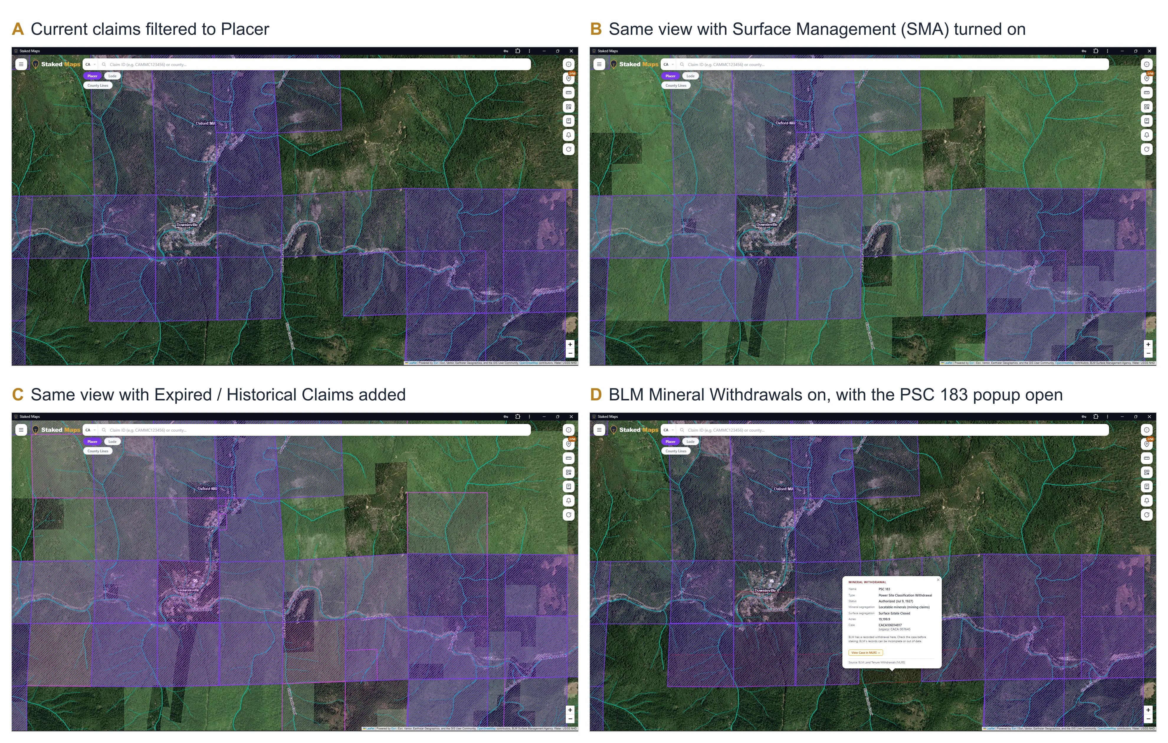
Step 8: Verify with the official records. For any specific spot:
- Look up nearby claims by serial number in BLM's Mineral & Land Records System (MLRS) to see current status, case history and claimants.
- Check the Sierra County Recorder for recorded location notices, since California requires locators to record there (see the staking section below).
- Call the Tahoe National Forest's local ranger district about closures and whether your planned activity needs a notice of intent.
- If you're working in or next to the river, confirm what CDFW allows.
Doing this research on a map instead of eight websites. Every step above uses data you can view together on the Staked Maps California mining claims map. The free map shows current claims and surface management. Paid plans add the placer and lode filter, the expired and historical claims layer, BLM mineral withdrawals with case details, and claim popups that flag withdrawal overlaps. My Research saves claims, pins and notes for a district in one project. Claim Sluice watches the claims and areas you choose, and every night it checks for new claims, status changes and closures. Staked Maps is a research tool. It doesn't replace BLM, Forest Service, county or CDFW records.
What Closed and Recently Changed Claims Add
Claim records change constantly. New claims get filed, maintenance fees go unpaid, and claims close. Two things help:
- Recent activity. A claim filed last month may not show up everywhere yet, and a claim that just closed may still show up in some sources. Staked Maps' Recent Claim Activity shows new, changed and closed claims from the last 30 days, so you can see whether a district is busy right now.
- Status vocabulary. BLM uses Active, Filed, Under Review and Closed, and the differences matter when you're deciding whether ground might come open. What BLM Mining Claim Statuses Mean explains each one.
A recently closed claim can make ground look open when it isn't. Before acting on one, confirm the closure in MLRS, check that no new claim has been filed over the same ground, and run the land status and withdrawal checks again.
Staking a California Placer Claim: State and Federal Filings
Staking in California involves both federal and state filings. In outline:
- Confirm the ground is open to location: federal mineral estate, not withdrawn (or, for powersite land, opened under the 1955 Act), and not already claimed. MLRS and the BLM California State Office are the authorities. See How to Find Out if a Mining Claim Exists.
- Locate the claim under California law. California Public Resources Code section 3902 requires a conspicuous, substantial monument at the point of discovery with a posted notice giving the claim name, the locator's name and current address, the date of posting and the amount of ground claimed. It also sets how the boundaries are marked, unless the claim is described by legal subdivisions of a U.S. survey.
- Record with the county. Under Public Resources Code section 3911, the locator must record a copy of the notice with the county recorder within 90 days of posting, with a statement of how the boundaries are marked and the section, township, range and meridian. A willfully false statement is a misdemeanor.
- File with BLM. Under 43 CFR 3833.11, a copy of the location notice must also be recorded with the BLM California State Office by the 90th day after the date of location. On powersite land, mark the filing as recorded under the Act of August 11, 1955; that satisfies the 1955 Act's separate filing requirement. For a new placer claim filed on or after September 1, 2024, BLM lists a $25 processing fee, a $49 location fee and a $200 maintenance fee for each 20 acres or portion of the claim. After that, the $200 per 20 acres is due by September 1 each year unless you qualify for the small miner waiver.
- Get surface authorization before you work. On National Forest land that means a notice of intent or plan of operations for anything beyond the casual activities listed earlier. On BLM land, 43 CFR 3809 sets the equivalent thresholds.
For claim basics, see What Is a Mining Claim? and How Long Does a Mining Claim Last?.
Common Questions About California Placer Gold
Do I need a permit to pan for gold in California?
On National Forest land, gold panning, metal detecting and non-motorized hand sluicing generally don't need a notice of intent under 36 CFR 228.4, unless the specific area is closed. Motorized suction dredging is banned statewide. Rules differ on state parks, private land and other agencies' land, and an existing mining claim still belongs to its holder.
Is suction dredging legal in California now?
No. As of October 31, 2026, CDFW says suction dredging is prohibited throughout California and CDFW can't issue permits. Nonmotorized recreational mining, such as panning, isn't covered by the ban.
Does a blank spot between claims mean the ground is open?
No. The ground could be private, withdrawn, inside a licensed power project, recently claimed, or patented. Run the surface, withdrawal and records checks above before treating any gap as open.
Are the big desert placer claim blocks about gold?
Not necessarily. About one in five of California's current placer claims sit in two large groups around Cuddeback Lake and Bristol Lake, both dry lakebeds in San Bernardino County. Bristol Dry Lake has a long history of calcium chloride production from its brines. For placer gold, the northern Sierra and Klamath Mountains counties are the more useful places to start.
Before You Head Up Highway 49
California's gold regions are heavily claimed in places, largely managed by the Forest Service, crossed by old powersite withdrawals and covered by strict state stream rules. None of that makes it off limits. It means the work happens in a specific order:
- Start from documented production.
- Translate the district into townships.
- Separate placer claims from lode.
- Read the closed claims as history.
- Check the surface manager.
- Check withdrawals, including whether a powersite withdrawal is the open kind.
- Confirm everything with BLM, the ranger district, the county recorder and CDFW.
To work through those steps for any California district, open the California mining claims map, or start with the county pages for Nevada County and Siskiyou County. For how the same research works in a desert placer state, see Arizona Placer Gold Prospecting.
Where These Numbers Come From
- County figures are from Staked Maps' California dataset as of October 28, 2026 (the same data as the California mining claims page). "Current" means not closed: Active, Filed or Under Review.
- Township, lakebed and withdrawal figures were pulled from BLM's mining claim and withdrawal map services on October 31, 2026. Township counts use BLM's legal description field for each claim (for example, "CA 21 0200N 0100E" for T20N R10E, Mount Diablo Meridian). A claim that lists two townships counts in both.
- Lakebed groups: claims named CDL (including variants such as Z2-CDL), Amboy, Bristol or calcium chloride names, out of 11,231 current California placer claims in BLM's service that day.
- Surface management shares come from a 100-point grid sample of BLM's Surface Management Agency data across each township. They're estimates.
- PSC 183 counts use each claim's approximate center against BLM's withdrawal boundary. Claims along the edge may fall either way, so the figures are rounded.
This guide was checked against current BLM, Forest Service, CDFW, U.S. Code and California code sources as of October 31, 2026.
Sources
- W.B. Clark, Gold Districts of California, California Division of Mines and Geology Bulletin 193 (1970), Downieville district entry (reproduced by the Oakland Museum of California).
- U.S. Bureau of Land Management, Mining Claims map service (active and closed claims) and Withdrawals map service, queried October 31, 2026.
- BLM, Surface Management Agency map service.
- BLM, Mining Claim Fees
- 36 CFR 228.4, Forest Service locatable minerals rules (eCFR, current as of October 2026).
- Forest Service, Locatable Minerals: Work to Update Regulations, and 91 FR 8316 (February 20, 2026).
- 30 U.S.C. 621 (Mining Claims Rights Restoration Act of 1955), via govinfo.gov.
- 43 CFR Part 3730, Mining in Powersite Withdrawals, and 43 CFR 3833.11, recording mining claims with BLM.
- 16 U.S.C. 1280 (Wild and Scenic Rivers Act, mining and mineral leasing).
- California Department of Fish and Wildlife, Suction Dredge Permits
- CDFW, Lake and Streambed Alteration Program (Fish and Game Code section 1602)
- California Public Resources Code sections 3902 and 3911.
- U.S. Geological Survey, Li and Ca enrichment in the Bristol Dry Lake brine compared to brines from Cadiz and Danby Dry Lakes.