
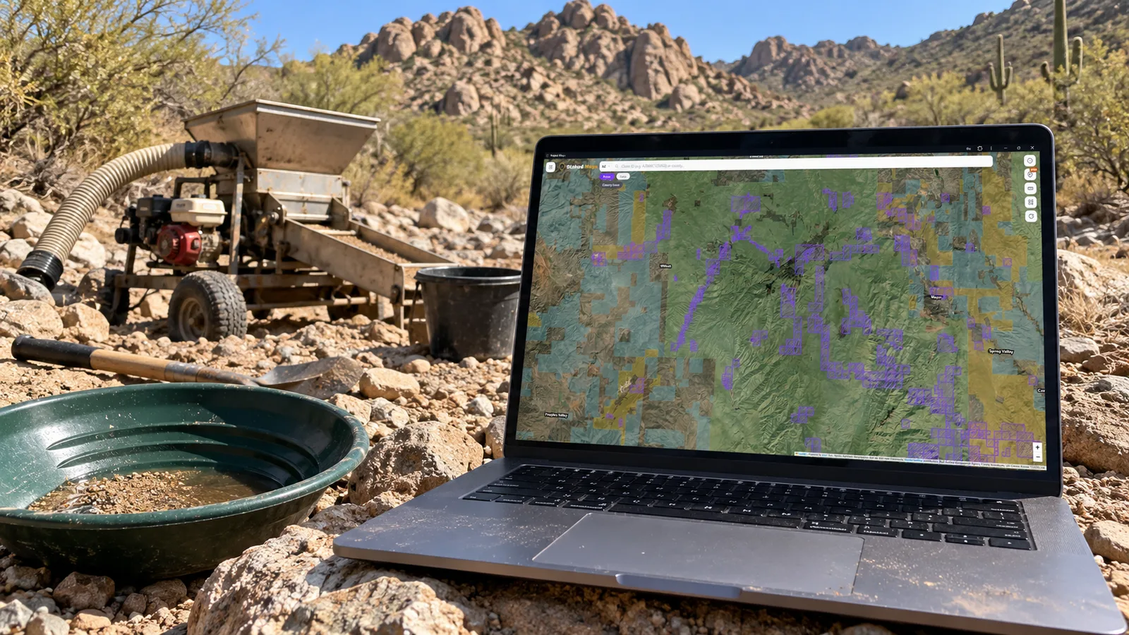
Finding Arizona placer gold ground takes four separate checks: where placer gold was actually recovered, whether that ground is claimed now, who manages the surface and minerals, and whether the land has been withdrawn from mineral entry. Historic gold maps answer only the first. A mining claim map answers only the second. Skipping either of the last two is how prospectors end up on State Trust Land, tribal land or withdrawn ground they had no right to work.
The good news is that each check has an authoritative source, and the sources fit together into a repeatable routine. This guide walks through that routine using three documented Arizona placer districts, current federal claim counts for each district from BLM data, and a step-by-step example near Rich Hill in Yavapai County.
One caution up front: an area with no current mining claims is not automatically open to prospecting or staking. It may be private, State Trust, tribal or withdrawn land, or it may be covered by records a map doesn't show yet. That point comes up again and again below because it's the most common and most costly mistake.
The Four Questions Behind Every Arizona Placer Spot
| Question | Best source | What it can't tell you |
|---|---|---|
| Was placer gold actually recovered here? | USGS Bulletin 1355, Arizona Geological Survey publications, USGS mineral occurrence records | Whether any gold remains, or whether you may look for it today |
| Is the ground claimed now? | BLM's Mineral & Land Records System (MLRS) and maps built from it | Whether unclaimed ground is open, or whether a claim is legally valid |
| Who manages the surface and owns the minerals? | BLM surface management data, Arizona State Land Department parcel records, county records | Whether the federal minerals are open to mineral entry |
| Has the land been withdrawn or specially designated? | BLM withdrawal records, Forest Service and BLM office guidance, Public Land Orders | Small or recent closures that haven't reached the digital data |
Keep these four questions separate. Most bad decisions come from letting one answer stand in for another, such as treating a famous historic district as open ground, or treating a gap between claims as an invitation to stake.
Start With Where Gold Was Actually Recovered
The best single starting point for Arizona placer research is U.S. Geological Survey Bulletin 1355, Placer Gold Deposits of Arizona (Maureen G. Johnson, 1972). It describes 87 placer districts that the USGS estimated produced a minimum of 564,052 ounces of placer gold from 1774 to 1968. For each district it gives a location by township and range, the extent of the placers, production history, the likely lode source, and the literature behind it.
That township and range location matters more than the narrative. It's the bridge between a historical report and a modern map. Every federal mining claim record also carries a legal description in the same township, range and section system, so you can line the two up directly.
Two more sources are worth keeping open:
- Arizona Geological Survey (AZGS) gold publications. The AZGS gold prospecting page links free digital copies of Gold Placers and Placering in Arizona, Placer Gold Deposits of Arizona and other gold references. Its online mining data collection also holds thousands of unpublished mine files and maps.
- USGS Mineral Resources Data System (MRDS). MRDS points mark documented mines, prospects and occurrences, including many placer records. They're useful for narrowing a district down to specific drainages. An MRDS point records that something was documented there. It doesn't mean the site is open to collecting or prospecting.
Bulletin 1355 also explains something useful about Arizona placers in general: most of the state's placer gold came from systems of small gold-quartz veinlets and stringers scattered through the bedrock of nearby mountain ranges. Large, concentrated deposits were the exception. That's one reason so much Arizona placer ground is dry, shallow and patchy, and why many districts were worked with drywashers instead of sluices.
Three Documented Districts and What the Records Show Today
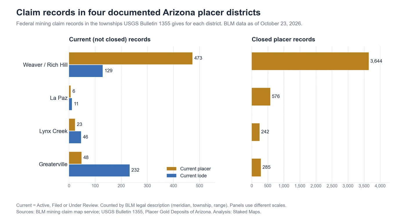
The table below lines up four Bulletin 1355 districts against current BLM claim records and the land managers on the ground. The three districts discussed in detail below show three very different situations. Greaterville is included for comparison.
| District (USGS Bulletin 1355 location) | Current placer records | Current lode records | Closed placer records | Main surface managers (sampled) |
|---|---|---|---|---|
| Weaver / Rich Hill, Yavapai County (Tps. 9 and 10 N., Rs. 4 and 5 W.) | 473 | 129 | 3,644 | BLM about half, State Trust about a third, private about an eighth |
| La Paz, La Paz County (Tps. 3 and 4 N., Rs. 21 and 22 W.) | 6 | 11 | 576 | Bureau of Indian Affairs about half, BLM about a fifth, Reclamation about a sixth |
| Lynx Creek, Yavapai County (Tps. 13 and 14 N., R. 1 W.; T. 14 N., R. 1 E.) | 23 | 46 | 242 | Private about half, Forest Service about a third, State Trust about a fifth |
| Greaterville, Pima County (T. 19 S., Rs. 15 and 16 E.) | 48 | 232 | 285 | Forest Service about two thirds |
Claim counts are federal mining claim records whose BLM legal description falls in the townships USGS Bulletin 1355 gives for each district, from BLM's public mining claim service as of October 23, 2026. "Current" means not closed; it includes Active, Filed and Under Review records. Surface manager shares are estimates from an evenly spaced sample of points across the same townships in BLM's surface management data. Township blocks are larger than the placer ground itself, so treat these as district-scale patterns, not counts of claims on the gold-bearing gravels. Full method at the end of the article.
Weaver and Rich Hill: Placer Country That's Still Heavily Claimed
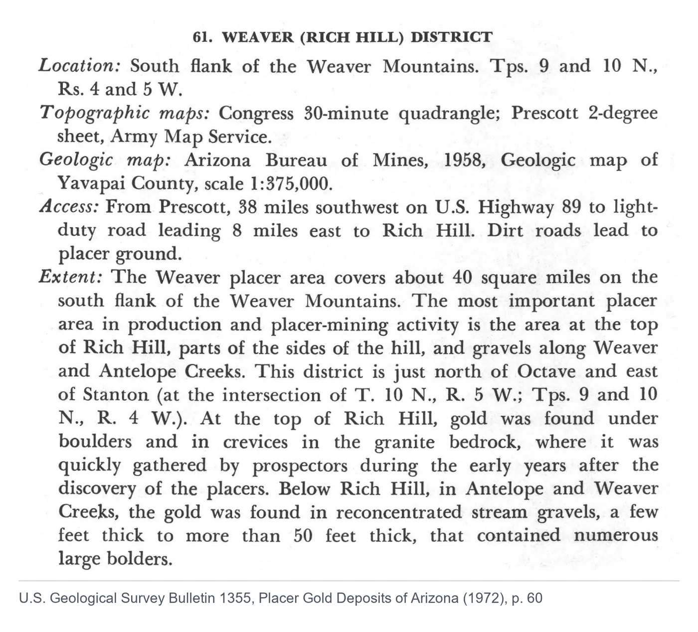
Bulletin 1355 places the Weaver (Rich Hill) district on the south flank of the Weaver Mountains, covering about 40 square miles. The richest ground was at the top of Rich Hill, where early prospectors picked up gold from under boulders and in crevices in the granite bedrock, and in reconcentrated gravels along Weaver and Antelope Creeks. Those creek gravels range from a few feet to more than 50 feet thick and contain many large boulders. The USGS notes that most mining there was done with drywashers, pans, rockers and sluices, and that about $1 million in placer gold had been recovered by 1883.
The modern claim records show that this is still placer country. In the four Weaver townships, 473 of the 603 current federal claim records are placer claims, about 78%. Across Arizona as a whole, placer claims make up roughly a tenth of current records. The closed records tell the same story: 3,644 of the 5,706 closed records in those townships are placer claims, compared with about 17% placer among Arizona's 433,741 closed records statewide.
What that means for a prospector: the Weaver district is well documented, but it is crowded. Hundreds of current placer claims, plus State Trust and private land covering roughly half the sampled area, leave much less open federal ground than the district's reputation suggests. It's a good place to learn the research routine, and a bad place to assume a gap on the map is available.
La Paz: Famous Nuggets, Very Few Current Claims
Arizona's first placer rush came in 1858 at Gila City, near Yuma. La Paz, on the west flank of the Dome Rock Mountains, followed in the early 1860s. According to Bulletin 1355, Pauline Weaver found gold there in January 1862, about $1 million was recovered the first year, and another $1 million by 1864, when the rich placers were worked out. The district produced some of Arizona's best-known nuggets, including one valued at about $1,150 at the time (about 65 ounces). The bulletin also notes that the district has at times been part of the Colorado River Indian Reservation, which interrupted later mining.
Today the federal claim record is almost empty: 6 current placer records and 11 current lode records across the four La Paz townships, against 576 closed placer records. Nearly all of those closed placer records sit in the two eastern townships (T. 3 N. and T. 4 N., R. 21 W.). The two western townships near the Colorado River have 4 closed placer records between them, and none current.
The surface management sample helps explain why this is not a simple story of "worked out and abandoned." About half of the sampled points across the four townships fall on land administered by the Bureau of Indian Affairs, about a sixth on Bureau of Reclamation land, and only about a fifth on BLM land. A Bureau of Reclamation withdrawal of all minerals for Colorado River storage (BLM case AZA 012864) also crosses part of the district, although almost none of the claim records, current or closed, touch it.
What that means for a prospector: few current claims and a famous name don't make an open district. Tribal land is not open to mineral location under the federal mining laws, and Reclamation land and withdrawals carry their own rules. The claim data shows how sharply activity has dropped here. It doesn't explain why for any particular piece of ground. That answer is in each closed claim's case record and in the land status of the specific parcel.
Lynx Creek: When Official Sources Don't Agree
Bulletin 1355 calls Lynx Creek "the most productive gold-bearing stream in Arizona," with placers along its entire length from near Walker, southeast of Prescott, down to its junction with the Agua Fria River. Gold was discovered there in May 1863, and dredges later worked about five miles of lower Lynx Creek. (The bulletin notes that La Paz and Weaver produced more gold overall, mostly from fans, flats and arroyos rather than a single stream.)
Today, Lynx Creek shows why the last of the four questions matters. The Prescott National Forest manages the Lynx Creek Gold Pan Day Use Area for recreational panning, and its current rockhounding page sets rules for the area's withdrawal boundary, including that only gold pans, metal detectors and hand tools may be used. Meanwhile, the 2000 Public Land Order (PLO 7439) that withdrew the Lynx Creek Recreation Area Expansion from the mining laws was written for a 20-year term, and BLM's digital withdrawal data showed no withdrawal in the Lynx Creek townships when we checked on October 23, 2026. We could not confirm from the official record what currently covers the panning area, and older articles that describe a permanent withdrawal there don't settle the question either.
When records disagree like this, the managing office decides. For Lynx Creek, that means calling the Prescott National Forest before you assume either that the area is closed to claims or that it's open to them.
The other numbers for the Lynx Creek townships are a reminder of how much of this district is no longer public land at all. About half of the sampled points fell on private land. There are 23 current placer records in the three townships, almost all in T. 13 N., R. 1 W., the upper part of the drainage.
What Current Placer Concentrations Tell You (and What They Don't)
A dense cluster of current placer claims tells you three things with reasonable confidence:
- Other people think the ground is worth holding. Each placer claim costs at least $200 a year per 20 acres to maintain, unless the claimant qualifies for the small miner waiver, so a large, persistent cluster usually reflects real interest.
- The ground near the cluster is probably contested. Claims tend to be staked edge to edge along productive drainages. Gaps are often smaller than they look on a map, because many BLM claim shapes are approximations rather than surveyed boundaries.
- You need permission to prospect there. On a current claim, the claimant holds the right to the locatable minerals. Panning or detecting on someone else's claim without permission takes minerals that belong to their claim.
A cluster doesn't tell you that gold remains in paying quantities, that any particular claim is legally valid, or that the ground around it is open. In the Weaver district, the cluster mostly confirms what the USGS documented decades ago. In Greaterville, where lode claims outnumber placer claims about five to one, the current records point more toward hard-rock interest than placer activity.
How to Read Historical Claims Without Overreading Them
Historical claims are the closed side of BLM's records: claims that were abandoned, relinquished, forfeited for missed fees or rejected. For Arizona there are 433,741 closed federal claim records in BLM's public service, compared with about 66,000 current ones.
Closed placer claims are useful because they show where people filed placer claims in the past. When thousands of closed placer records stack up in the same townships as a Bulletin 1355 district, as in Weaver, you're seeing long-term interest in that ground.
They are not evidence of three things:
- Gold. A filing shows that someone thought the ground was worth claiming. It doesn't show that they recovered anything.
- Availability. A closed claim no longer holds the ground in BLM's records, but a newer claim, a withdrawal, private or State Trust land, or a tribal boundary can still cover the same spot.
- Precise location. Many older records are mapped from their legal description, sometimes only to the quarter section or section. Treat their shapes as approximate.
The useful comparison is between historical and current activity in the same place. Weaver has both, which suggests steady interest. La Paz has plenty of history and almost no current claims, which tells you to find out why before you spend time there. Our guide to abandoned mines and historical mining claims goes deeper on what old records can and can't show.
A Worked Example: Researching Ground Near Rich Hill
Here's how the four checks work together in practice, using the Weaver district. The same steps work for any district in Bulletin 1355.
1. Pin down the district from the primary source. Bulletin 1355 gives Tps. 9 and 10 N., Rs. 4 and 5 W., names Weaver and Antelope Creeks and Rich Hill, and describes the gravels and mining methods. Write down the township and range and the named drainages before you open any map.
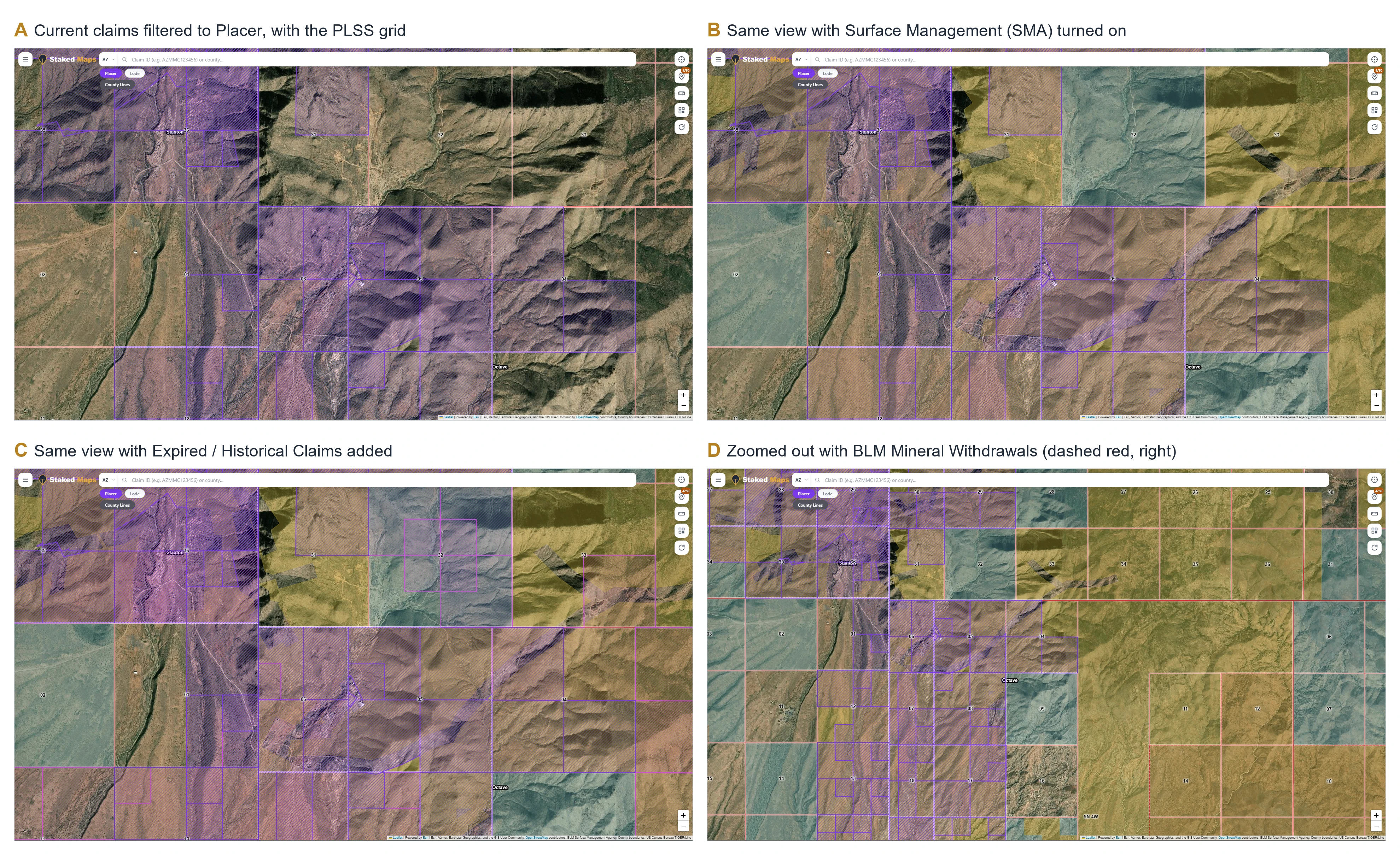
2. Put the map on the same grid. In Staked Maps, turn on the PLSS Grid to see township, range and section lines, and use Creeks, Rivers & Lakes to find Weaver and Antelope Creeks. Rockhound Hotspots shows USGS MRDS mine and prospect points, so you can see where documented placer workings sit along those drainages.
3. Filter to placer claims. Turn on Current Mining Claims and filter by claim type to show only placer claims. In the Weaver townships, that's 473 current placer records (as of October 23, 2026). Filtering out the lode claims shows which drainages placer claimants are actually holding, which a mixed map hides.
4. Add the history. Turn on Expired / Historical Claims. Where closed placer claims stack up along the same creeks as current ones, interest has lasted for decades. Where closed claims cover ground that now has no current claims, write that location down for a closer look in the next steps rather than treating it as available.
5. Read the status, not just the shape. Click a claim to see its details. Of the 473 current placer records in the Weaver townships, 406 were Active, 50 were Filed and 17 were Under Review. Those labels mean different things (see the next section), and none of them means "open." Use the claim's BLM record link to open the official case in MLRS.
6. Check who manages the surface. Turn on Surface Management (SMA). In the Weaver townships, about half the sampled ground was BLM, about a third State Trust and about an eighth private. A promising gap between claims that falls on a State Trust parcel is off limits for prospecting under a recreational permit.
7. Check for withdrawals. Turn on BLM Mineral Withdrawals. Two withdrawals in BLM's data cross the Weaver townships: the Hassayampa River wilderness withdrawal (BLM wilderness designation, all minerals, case AZA 025479) and a Bureau of Reclamation withdrawal for the Hassayampa Project (locatable minerals, case AZA 012833). They don't cover the whole district, but any ground inside them is not open to new claims.
8. Confirm what the map can't. For any spot that survives steps 3 through 7, check the official records: MLRS for claims and case history, the Yavapai County Recorder for recent location notices that may not have reached BLM's data yet, and the BLM Arizona office that manages the land for local closures or restrictions.
Only after all eight steps do you know whether a spot is worth a trip, and whether you'd need someone's permission to work it.
Do this research on the Arizona map. Steps 2 through 7 are layers in one map in Staked Maps. The Arizona mining claim map shows current claims and surface management for free. The placer filter, historical claims, PLSS grid, creeks and withdrawals are part of a paid Mining Pass, so you can run the whole routine without jumping between BLM, USGS and county websites. Staked Maps is a research tool. It doesn't certify that land is open, and the official records in step 8 still have the final word.
Active, Filed, Under Review and Closed Mean Different Things
Arizona's current federal claim records carry several BLM status values, and they shouldn't all be read as "a confirmed active claim":
- Active: BLM has completed its land status review and found the claim in compliance at the time it looked. It still doesn't certify that the claim is valid under the mining law.
- Filed: BLM has finished data entry, and the claim is waiting on land status review.
- Under Review: the claim is in the final stages of that review. It can end up Active or Closed.
- Closed: the claim was abandoned, relinquished, forfeited or rejected. The ground may still be covered by something else.
For prospecting purposes, treat Active, Filed and Under Review claims the same way: someone has asserted rights there, so get permission or stay off. Our guide to what each BLM mining claim status means quotes BLM's definitions and explains the edge cases.
Who Manages the Surface Changes Everything in Arizona
Arizona's land ownership is a patchwork, and the federal mining laws apply only to part of it.
BLM land. Federal minerals on BLM land are often open to prospecting and claim location, but only where they haven't been withdrawn or otherwise closed. Hand panning and other activities that cause only negligible disturbance count as "casual use" under BLM's surface management rules (43 CFR 3809.5). Our guide to keeping gold you pan on BLM land covers the details.
National Forest land. Forest Service land can also be open to mineral entry, with BLM keeping the mining claim records. Forests set their own rules for special areas, such as the equipment limits at Lynx Creek.
Arizona State Trust Land. State Trust Land is managed by the Arizona State Land Department for trust beneficiaries, and it isn't federal public land. You need a State Land Department recreational permit just to be on Trust land for recreation (licensed hunters and anglers actively hunting or fishing in season are exempt), and entering without one or breaking its terms can be treated as trespassing. The department's list of allowed activities covers things like hiking, horseback riding, picnicking, photography, geocaching, camping and OHV travel on existing roads and trails. Prospecting and metal detecting aren't on it. The Arizona Geological Survey states plainly: "Recreational mining or mineral collecting on State Trust land is prohibited." The State Land Department's own permit terms say the same thing. Its recreational permit is issued only for "non-commercial, non-competitive, and non-consumptive recreational activities," and the permittee agrees: "I will not collect or remove any natural products or cultural resources from State Trust land." The department defines natural products to include rock, boulders, sand and gravel, which covers anything you'd pan, sluice or drywash. The permit also states that it doesn't include authorization for any other use, and that lands leased for mining or other purposes aren't open to recreational use. Mineral exploration on Trust land goes through a separate State Land Department process, the Mineral Exploration Permit, which involves an application, a bond and surveys. It's built for exploration companies, not weekend prospectors. In the Weaver townships, State Trust parcels covered about a third of the sampled ground, so this is not a rare situation.
Tribal land. Tribal land is not open to mineral location under the federal mining laws. Prospecting there requires authorization from the tribe.
Private land. Private land, including patented mining claims, needs the owner's permission. If you're after minerals, check separately who owns the mineral rights. See mineral rights vs. mining claims for how surface and mineral ownership can split.
Our guide on how to tell if land is BLM land walks through the surface management check in more detail.
Withdrawals Override Everything Else
A withdrawal removes land from some or all of the public land laws. Withdrawals from the mining laws close the land to new mining claims, subject to valid existing rights. They can come from Congress (wilderness areas and national conservation areas), from Public Land Orders, or from agency withdrawals for projects like reservoirs.
The district examples show how often they come up. BLM's data showed withdrawals crossing three of the four district township blocks: the Hassayampa River wilderness and Hassayampa Project withdrawals near Weaver; the Mount Wrightson Wilderness, Las Cienegas National Conservation Area and Florida Canyon withdrawals near Greaterville; and the Colorado River storage withdrawal near La Paz.
Two cautions:
- Withdrawals have terms. Many Public Land Orders run for 20 years unless extended, so an old brochure or website can be wrong in either direction. Lynx Creek is the example above.
- Digital data has gaps. BLM's withdrawal map is the best public starting point, but small or recent withdrawals can be missing or mapped imprecisely. For ground you plan to work or stake, confirm with the managing BLM or Forest Service office.
Why "No Current Claims" Doesn't Mean Open Ground
An empty spot on a mining claim map is one answer to one question. Before you treat it as available, rule out each of these:
- Private or patented land. Check surface management and county parcel records.
- State Trust Land. You need a permit just to enter, and recreational permits don't cover prospecting.
- Tribal land. Not open to mineral location under the federal mining laws.
- A withdrawal or special designation. Wilderness, national monuments, conservation areas, recreation sites and project withdrawals.
- Claims not yet in BLM's data. A new claim can be located and recorded with the county weeks before it shows up in MLRS. Arizona gives a locator 90 days to record with the county, and federal law allows 90 days to file with BLM.
- Mapping limits. Approximate claim shapes can leave apparent gaps between claims that are actually adjacent on the ground.
- Federal minerals not open to entry. Acquired lands and some other federal mineral estates follow different laws.
The opposite mistake matters too: a closed claim on the map doesn't mean the ground became open when it closed. Ground can be closed to new claims for any of the reasons above.
If You Plan to Stake a Placer Claim in Arizona
If your research finds federal ground that looks open, staking a claim brings two sets of rules.
Federal requirements. You file the claim with the BLM Arizona State Office within 90 days of location and pay the fees. For a new placer claim, those are currently a $25 processing fee, a $49 location fee and a $200 maintenance fee per 20 acres or portion thereof. After that, the $200 per 20 acres maintenance fee (or a small miner waiver, for claimants holding 10 or fewer claims) is due on or before September 1 each year. Check the BLM mining claim fee page for current amounts before you file.
Arizona requirements. Under Arizona Revised Statutes § 27-203, within 90 days of location you must record a copy of the location notice with the county recorder of the county where the claim lies, along with a map or sketch of the claim, and monument the claim so its boundaries can be readily traced. The statute sets out what the map must show. Failing to complete these steps within the required times is treated as abandonment of the claim.
Staked Maps' Draft A Claim tool, part of the paid Mining Pass, lets you sketch a prospective claim on the map, see its PLSS legal description, and generate a draft Certificate of Location PDF to review and complete. It belongs at the end of this process, after you've confirmed land status, mineral status and the absence of conflicting claims. It doesn't replace the BLM filing, the county recording or the work of physically locating and monumenting the claim. For the bigger picture, see what a mining claim is and how long a mining claim lasts.
Questions Arizona Placer Prospectors Ask
Where is the best placer gold in Arizona?
USGS Bulletin 1355 is the most complete answer for historical production. It describes 87 districts. Many of the best known are in central Arizona, on the flanks of the Bradshaw Mountains (including Lynx Creek) and in the nearby Weaver Mountains (Rich Hill), with others in western Arizona such as La Paz and Plomosa. Historical production tells you where gold was found, not where you may legally look for it now.
Can I metal detect for gold on Arizona State Trust Land?
Not for prospecting under a recreational permit. The permit's terms bar collecting or removing natural products, including rock, sand and gravel, and the Arizona Geological Survey states that recreational mining or mineral collecting on State Trust land is prohibited. Mineral exploration needs a separate State Land Department permit. Check with the Arizona State Land Department for the rules on any specific parcel.
How do I check whether a spot in Arizona is already claimed?
Search BLM's Mineral & Land Records System or use a map built from BLM claim data, then confirm with the county recorder for very recent locations. Our step-by-step guide to finding out if a mining claim exists covers both.
Do I need a permit to pan for gold on BLM land in Arizona?
Usually not, for hand panning that causes negligible disturbance on BLM land that's open to mineral entry and not covered by someone else's claim. Mechanized equipment, larger disturbance, special management areas and existing claims change that answer.
Narrowing Arizona Ground Before You Load the Truck
The prospectors who do best in Arizona usually aren't the ones with the longest list of famous districts. They're the ones who can cross a district off the list quickly. Start with the USGS record for where gold was actually recovered, then work through current claims, historical claims, surface management and withdrawals for that exact township. By the end, most spots will be ruled out, and the few that are left will be worth a phone call to the land office and a trip.
Research Arizona Placer Ground on One Map
See current Arizona mining claims and land ownership free. A Mining Pass adds the placer filter, historical claims, PLSS grid, creeks and BLM withdrawals used in the Rich Hill example.
Open the Arizona Claim MapNo credit card required.
County pages for Yavapai County and La Paz County cover claim patterns at county scale.
How the District Numbers Were Calculated
- Claim counts come from BLM's public mining claim map service (the data behind MLRS maps), queried October 23, 2026. A record is counted in a district when its BLM legal description (meridian, township and range) falls in one of the townships USGS Bulletin 1355 gives for that district. Counting by legal description avoids picking up claims along township edges, which spatial queries tend to include. Placer counts include BLM case types for placer claims, and lode counts include lode claims. Mill and tunnel sites are excluded from both.
- "Current" means not closed (Active, Filed or Under Review on the query date). "Closed" means records in BLM's closed claims layer.
- Statewide figures use the same service: 433,741 closed Arizona federal claim records, of which 73,814 are placer, and about 66,000 current records.
- Surface management shares come from an evenly spaced grid of 147 to 196 points per district across the same townships in BLM's national surface management dataset, rounded to simple fractions. They're estimates, and township blocks include ground outside the placer areas themselves.
- Withdrawals are those in BLM's withdrawal map service that intersect the district townships, checked October 23, 2026.
This guide was checked against current BLM, Forest Service, Arizona Geological Survey and Arizona statutory sources as of October 23, 2026. Claim counts reflect BLM data on that date and will change as claims are located and closed.
Primary Sources Used in This Guide
- U.S. Geological Survey, Bulletin 1355: Placer Gold Deposits of Arizona (Johnson, 1972)
- Arizona Geological Survey, Gold Prospecting in Arizona and Mineral Rights
- Bureau of Land Management, Mineral & Land Records System (MLRS)
- Bureau of Land Management, Mining Claim Fees
- Bureau of Land Management, Arizona Mining and Minerals
- 43 CFR 3809.5, definition of casual use
- Arizona Revised Statutes § 27-203
- Arizona State Land Department, Applications & Permits and State Land Recreational Use Group Permit terms and conditions
- Prescott National Forest, Rocks & Minerals
- Public Land Order 7439, 65 FR 14614 (March 17, 2000)