
The Short Answer
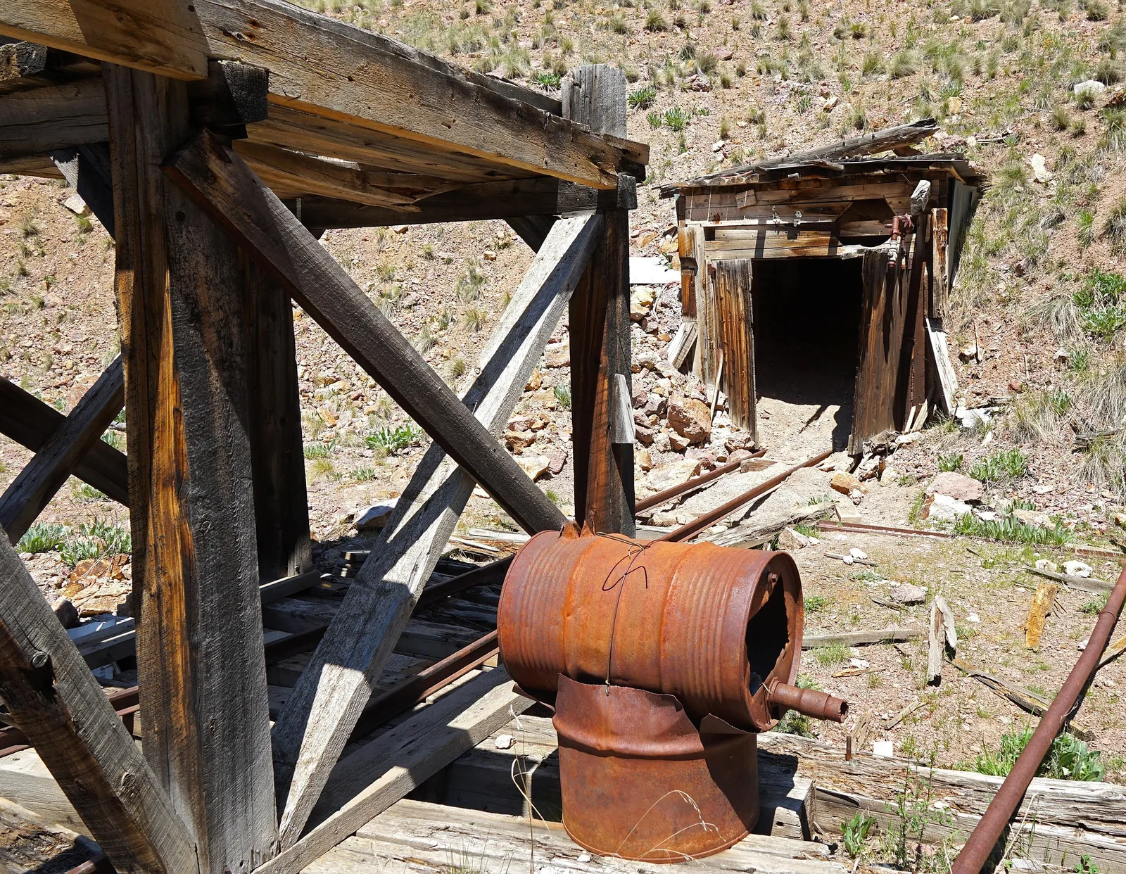
An abandoned mine and a historical mining claim are not the same thing.
In fact, there are three different concepts that are easy to mix together:
| Term | What it means |
|---|---|
| Abandoned mine | A physical mine site or mining feature where mining activity stopped. BLM's Abandoned Mine Lands program uses a specific definition for abandoned hardrock mines on or affecting BLM-administered lands. |
| Abandoned or forfeited mining claim | A mining claim that has been given up or lost through a claim administration process, such as relinquishment or failure to meet certain federal requirements. |
| Historical claim in Staked Maps | A record from BLM's closed mining claims data showing that a mining claim or site was recorded there in the past. It is a research record, not proof that the ground is open today. |
Those distinctions matter.
A piece of ground can contain dangerous abandoned mine workings and a current mining claim at the same time. A historical claim can exist in the records even if no shaft, tunnel or other mine working was ever built there.
And a closed historical claim does not mean you can automatically go stake the same ground. That requires a separate land status investigation.
What Does BLM Mean by an "Abandoned Mine"?
For its Abandoned Mine Lands (AML) program, the Bureau of Land Management uses a much more specific definition than "an old mine nobody uses anymore."
BLM's AML program defines an abandoned mine as an abandoned hardrock mine on or affecting BLM-administered public lands where exploration, development, mining, reclamation, maintenance, inspection and related operations had ceased as of January 1, 1981, with no evidence that the operator intends to resume operations.
That date is the effective date of BLM's modern Surface Management regulations at 43 CFR 3809. It is the cutoff for this one federal program, not a universal definition of every old mine in the country.
The features and problems BLM's AML program deals with include:
- shafts, adits, winzes and raises
- steep slopes and unstable high walls
- deteriorating buildings and structures
- waste rock, mill tailings and retort waste
- settling ponds and other water-retaining features
- acid and caustic rock drainage
None of that says anything about the status of a mining claim record. Those live in a different system entirely.
Source: BLM, About the BLM's Abandoned Mine Lands Program.
An Abandoned Mine and an Abandoned Claim Are Different Things
The word abandoned causes much of the confusion, because it also shows up in mining claim administration.
A claimant can voluntarily relinquish a claim. And under federal law, missing certain requirements has the same effect. BLM notes that failing to record a claim on time may result in it being considered abandoned, and that failing to pay the annual maintenance fee or file a small miner waiver on time subjects claims to forfeiture by law. (For more on those deadlines, see how mining claims close or go void.)
All of that describes what happened to the claim rights or the record. It tells you nothing about whether a shaft, adit, open cut, tailings pile or any other physical feature exists on the ground.
The reverse is also true. An abandoned physical mine tells you nothing about whether the land has a current mining claim over it. BLM has issued specific guidance for mitigating abandoned mine hazards on active mining claims, which only exists because the two overlap.
The simplest way to keep it straight:
Mine condition and claim status are two separate questions.
One is about what physically exists on the land. The other is about the administrative record attached to mineral claims.
What Does "Historical Claim" Mean in Staked Maps?
Staked Maps uses historical claim as a plain-English label for mining claim and site records that come from BLM's closed claims data.
BLM publishes a separate geospatial dataset for mining claim cases with a closed disposition in its Mineral & Land Records System. Those records document past claim activity and show where people previously located claims. (In Alaska, the historical layer also includes closed state mining claims from the Alaska Department of Natural Resources.)
The word historical should not be read as:
- "abandoned mine"
- "available claim"
- "unclaimed land"
- "public land"
- "open to mineral entry"
It means there is a past mining claim record associated with that location. Nothing more.
Why a particular claim closed may take a look at its individual BLM case record. A closed status alone isn't enough to assume whether the claimant relinquished it, missed a fee, or something else happened.
Historical claim data is still useful, because claim activity that has disappeared from a current claims map says something about the mining history of an area. It just doesn't answer every question.
Does a Historical or Closed Mining Claim Mean the Ground Is Open?
No.
This is one of the most important distinctions to understand before prospecting or locating a mining claim.
BLM says claims can be located on public and National Forest System land open to mineral entry, that they cannot be staked on acquired minerals, and that they may not be located in areas closed to mineral entry by an act of Congress, regulation or public land order. A missing claim record doesn't satisfy any of those conditions on its own.
Land can look empty on a claims map and still be unavailable because:
- the mineral estate isn't federal public domain mineral estate
- the land or minerals have been withdrawn from mineral entry
- a special land designation restricts new claim location
- a newer claim or filing affects the area
- the surface and mineral estates have different owners (see why mineral ownership and mining claims are separate questions)
- the land is private, state-owned or otherwise outside ordinary federal claim location
- official records contain details that aren't obvious from a generalized map layer
BLM's own staking guidance says a prospector should check BLM records for prior recorded claims before locating, and check the ground for existing claim markers too.
A closed claim is evidence of past claim activity. It is not an official determination that the ground is currently available to claim.
Use Staked Maps to identify and investigate areas efficiently, then verify land and claim status through the official records (for federal claims, BLM's Mineral & Land Records System) before relying on it for a real-world decision.
Can an Active Mining Claim Contain an Abandoned Mine?
Yes.
This is the clearest example of why physical mine history and current claim status shouldn't be treated as one dataset.
An old shaft or adit may have been dug decades before the current claimant ever saw the ground. Claims close, new claims get located in the same area later, and physical workings stay put long after the people who made them are gone. BLM has procedures written specifically for abandoned mine hazards found on active claims.
So at a single location you can find:
- evidence of historic mining
- abandoned physical workings
- old closed claim records
- a newer current mining claim
A modern claims map cannot tell you the physical condition of an old mine opening. An abandoned mine inventory cannot tell you everything about current claim rights. They answer different questions.
How Many Abandoned Mines Are There?
No single nationwide inventory captures every abandoned mine.
BLM says as many as half a million abandoned mines are believed to exist nationwide, and that the location of many more is still unknown.
California shows the scale. BLM California estimates about 47,000 abandoned mine land sites statewide, including about 24,400 sites on BLM-managed land.
Another major federal resource is the National Mine Map Repository, run by the Office of Surface Mining Reclamation and Enforcement to archive closed and abandoned mine maps. It holds data on more than 275,000 mines, with records dating from the 1790s to the present.
Don't add these numbers together. Different agencies keep different collections for different purposes, and they overlap.
The bigger point is that abandoned and historic mine features are widespread, especially in areas with long mining histories.
What Historical Claims Can Actually Tell You
Read correctly, historical claims are genuinely useful research data. They can help you find:
Areas with documented past claim activity
A dense cluster of old claims shows that people repeatedly considered an area worth locating. That doesn't prove a valuable deposit exists there today, but it gives you something more meaningful to investigate than a spot picked at random.
Patterns that disappear from current claim maps
A current claims layer answers one question: what claim activity is recorded as current right now?
Historical records answer a different one: where has claim activity happened before?
Comparing the two can show districts where claim activity has persisted, shifted, shrunk or disappeared over time.
Leads for deeper records research
Historical records can give you claim names, case information, claim types and legal location details that lead into BLM case records, county records, old maps, geological reports and other primary sources.
Context for known mining districts
A historical claim cluster can place documented mines, mineral occurrences and modern claims into a broader geographic pattern.
Historical claim density is not a measure of grade, production or profitability, though. People filed plenty of unsuccessful claims too.
What Historical Claims Cannot Tell You
On its own, a historical mining claim layer cannot tell you:
- whether the land is currently open to mineral entry
- whether valuable minerals remain
- whether minerals were ever commercially produced
- who owns the mineral estate today
- whether you have legal surface access
- whether an abandoned mine physically exists there
- whether any old workings are safe
- whether the mapped historical geometry matches the exact surveyed claim boundary
- whether prospecting or mining activity is currently permitted
That's why claim research works best when you combine several kinds of information instead of trusting a single colored polygon.
A Real Example: Current and Historical Claims in the Same Area
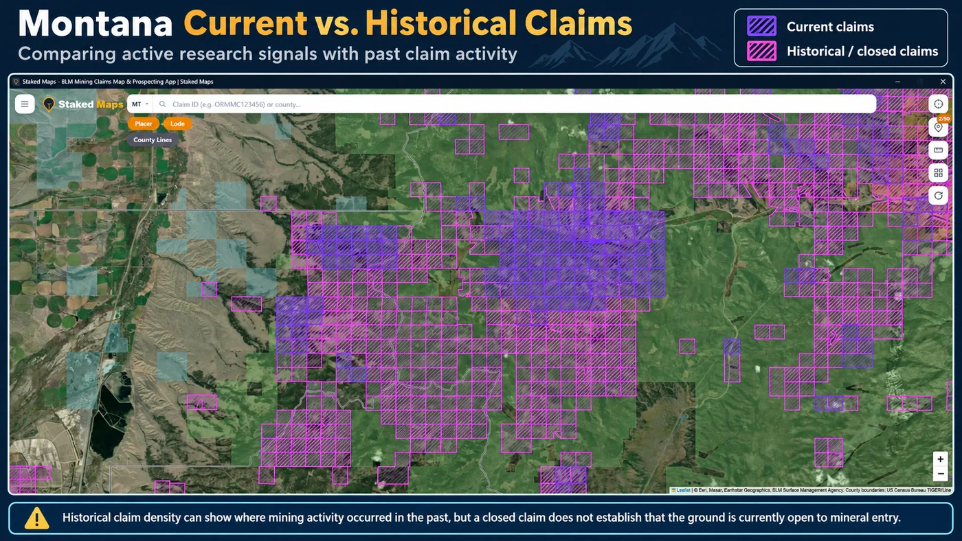
This Montana screenshot shows why viewing current and historical records together tells you more than either dataset alone.
In Staked Maps, the purple areas are current claim records and the pink areas are historical/closed claim records. Side by side, you can see where recorded claim activity continued into the present, where it appears only in the historical records, and where claim patterns shifted over time.
What the map does not do is turn every pink area into available ground. In Montana, figuring out whether land is actually open can mean researching federal mineral ownership, withdrawals, Montana State Trust Land, private ownership and other restrictions.
See how current and historical claims are researched together in Montana →
How to Research Old Mining Ground Before You Prospect
Finding evidence of old mining is where the research starts, not where it ends. Here's a workflow that holds up.
1. Start with current claim activity
Check whether BLM currently shows mining claim or site records in the area. If current claims are present, look at the individual records instead of assuming the ground next to them is available.
2. Turn on historical claims
Look at closed claim activity around the same area. Historical records can show whether miners repeatedly located ground there, and surface older claim names and patterns that a current-only map hides.
3. Check surface management
Figure out who manages or owns the surface. BLM land, National Forest System land, state land and private land don't operate under the same rules. And surface management alone doesn't necessarily tell you who owns the mineral estate underneath.
4. Research the mineral estate and land status
This is the step that decides whether "no current claim shown" means anything useful. Check whether the mineral estate is subject to federal mining law and whether the land is open to mineral entry. Withdrawals and other land status restrictions matter here.
5. Verify specific claim records
For federal claims, use BLM's Mineral & Land Records System when you need the official case record. Maps are research tools. The official case record controls when exact status matters.
6. Research physical mine history separately
If you're trying to find out whether old workings or abandoned mine hazards exist, you'll need to go beyond mining claim records. Useful sources include:
- BLM Abandoned Mine Lands information
- state abandoned mine programs
- state geological surveys
- historic USGS maps and reports
- the National Mine Map Repository
- historic county and mining district records
7. Verify before you head into the field
Claim records, land status, access and physical hazards can each change what you should do next. Use the map to narrow the research problem, then use authoritative records to confirm it.
What a Staked Maps Claim Map Can and Cannot Tell You
Staked Maps can help you
- Compare current and historical mining claim activity.
- See current BLM claim records on a map.
- Identify claim names and types where available.
- View surface-management information alongside claims.
- Research historic mining districts before a trip.
- Move from a mapped record into deeper claim research.
- Identify places worth investigating further.
Staked Maps cannot by itself
- Declare land legally open to mineral entry.
- Determine mineral ownership.
- Prove a mineral deposit is valuable.
- Give permission to cross private land.
- Guarantee survey-grade claim boundaries.
- Determine that an old mine is physically safe.
- Replace BLM, state, county or other official records.
Use Staked Maps to research. Use official records to verify.
Check Current Claim Activity Before You Go
See current BLM mining claim records and surface-management information for your state before assuming old mining ground is unclaimed.
Open My State Map FreeFree account · No credit card required
Where Can You Find Actual Abandoned Mine Records?
There's no single database that maps every abandoned mine in the United States. Different agencies keep different records for different purposes.
BLM Abandoned Mine Lands
BLM's AML program focuses on the physical safety and environmental hazards of abandoned hardrock mines on or affecting BLM-administered land. BLM also publishes regional and state AML information.
National Mine Map Repository
OSMRE's National Mine Map Repository archives closed and abandoned mine maps and holds data on more than 275,000 mines across the country, surface and underground. Its records can include mine and company names, underground mine plans, geology and historic surface features like old rail lines and roads.
The repository also cautions that it can't guarantee the completeness or accuracy of its maps, since they're donated and the information can't always be verified.
State abandoned mine programs and geological surveys
Many Western states maintain their own inventories, reclamation programs, geological reports or mine location resources. Coverage and terminology vary a lot from state to state.
That variability is one more reason not to read the absence of an AML marker as proof that no old workings exist.
Old Mine Workings Are a Safety Issue, Not a Shortcut
Historic mine workings are good evidence that mining happened in an area. They are not safe places to explore.
BLM's list of abandoned mine dangers includes unstable shafts and adits, high walls, deteriorated structures, water-retaining features and mine waste. Abandoned hardrock sites can also carry environmental contamination from acid drainage, tailings and other wastes.
Some hazards are obvious. Others aren't.
A vertical opening can be hidden by brush or loose material. Old timber can fail without warning. The air underground can be unsafe. Water can hide depth and unstable workings.
A mine being on public land, looking abandoned, or sitting near a closed claim does not make it safe to enter.
Treat old mine openings as hazards and stay out.
A 2026 Change: The First Federal Good Samaritan Permit Has Been Issued
Congress passed the Good Samaritan Remediation of Abandoned Hardrock Mines Act of 2024 so that qualified volunteer groups can clean up certain abandoned mine sites without taking on the liability risks that used to discourage that work. A "Good Samaritan" here is someone who didn't own or operate the site and had no role in creating the pollution.
The law set up a seven-year EPA pilot program that can issue up to 15 Good Samaritan remediation permits.
That program is now in use. On September 9, 2026, EPA announced it had approved the first permit under the law, to Trout Unlimited for work at the Bodie Mine site in Okanogan County, Washington.
The project targets abandoned mine tailings washing into nearby Toroda Creek. Under the permit, Trout Unlimited will remove contaminated soil and sediment, stabilize the streambank and restore native vegetation.
One permit won't make a dent in the nationwide abandoned mine problem, but it's a real change in how some legacy hardrock sites can get cleaned up.
Historical Mining Activity Is a Lead, Not an Answer
Old claims and mine workings matter because they document human interest in a place. Someone spent time, money or labor there.
Sometimes that history leads to useful geological information. Sometimes it leads nowhere.
- A historical claim does not prove a discovery.
- An abandoned mine does not prove nearby ground is available.
- A mineral occurrence does not prove you may legally collect there.
- An empty current claims layer does not prove land is open to staking.
"Was there mining here before?" only gets you started. The questions that move your research forward are: what does the historical evidence tell me, what is the status now, and what still needs to be verified?
That's where looking at current claims, historical claims, surface management, PLSS information and official records together beats relying on any one layer.
Research What Was Here Before
Current claims show one part of the story. Historical claims let you compare today's recorded claim activity with the ground people claimed in the past.
Explore Historical Claims in Staked MapsHistorical claims are included with Staked Maps' paid mining plans, along with full claim details, PLSS research layers and offline map tools.
The Bottom Line
An abandoned mine, an abandoned claim and a historical claim record are three different things.
- An abandoned mine is a physical mining site or feature. BLM's AML program applies a specific definition to abandoned hardrock mines on or affecting BLM-administered lands.
- An abandoned or forfeited claim describes what happened to a mining claim through a legal or administrative process.
- A historical claim in Staked Maps is a past claim or site record drawn from BLM's closed claims data.
None of those labels, by itself, establishes that land is currently open to mineral entry.
For prospecting research, look at the layers together:
past claim activity + current claims + surface management + land and mineral status + official records.
That tells you far more than whether a spot looks old or empty on a map.
Sources & Methodology
This article separates BLM mining claim records from physical abandoned mine records. Regulatory and factual statements were reviewed against official federal sources. Staked Maps' "historical claims" terminology refers to records displayed from BLM closed mining claim data and should not be read as a determination that land is legally open to mineral entry.
- Bureau of Land Management: About the Abandoned Mine Lands Program
- Bureau of Land Management: Abandoned Mine Lands
- Bureau of Land Management: Locating a Mining Claim
- Bureau of Land Management: Recording a Mining Claim or Site
- Bureau of Land Management: MLRS Mining Claims, Closed (dataset)
- Office of Surface Mining Reclamation and Enforcement: National Mine Map Repository
- U.S. EPA: Good Samaritan Remediation of Abandoned Hardrock Mines Program
- U.S. EPA: First Good Samaritan Permit for the Bodie Mine Site (September 9, 2026)
- BLM California: Abandoned Mine Lands
Regulatory and editorial content last reviewed September 24, 2026. Federal records and land status can change.